Friday, April 29, 2005
Friday 4-29: 11.20am report/forecast
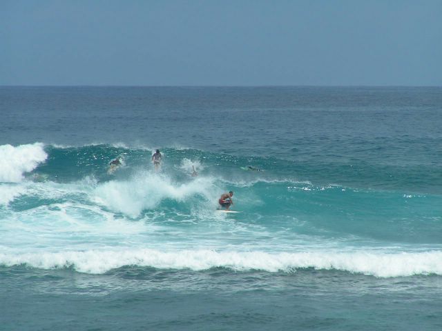
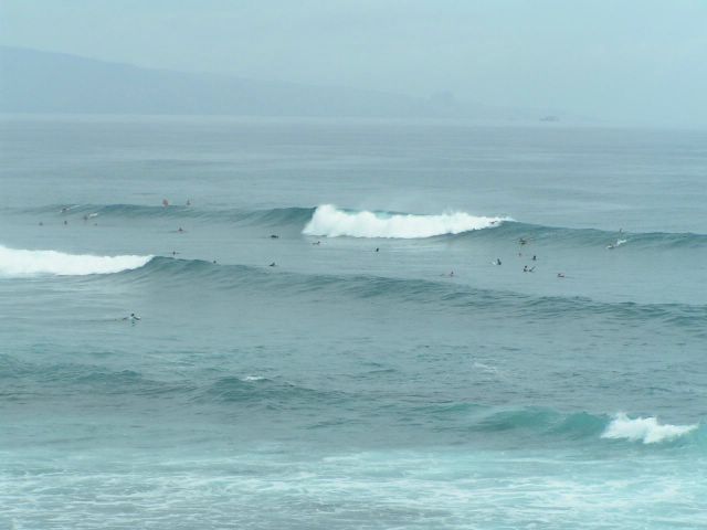
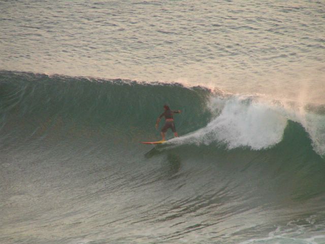
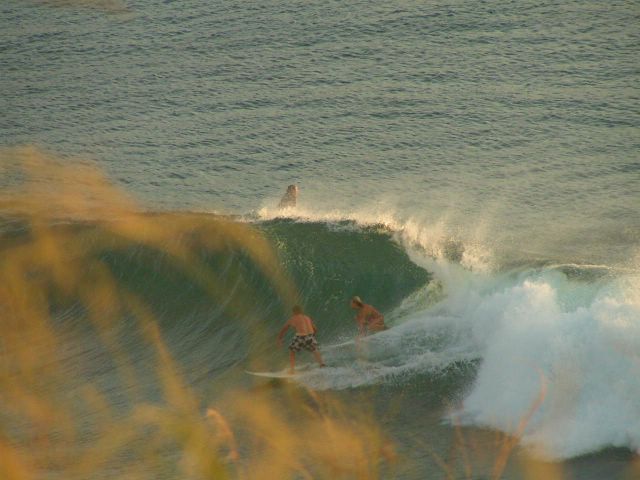
I'm sorry, I have to quote myself. What did I write last Tuesday? "Then Friday a new NNW pulse (being generated by another storm right in this moment) will arrive. The closer distance from Hawaii will maybe make for a little bigger size, but shorter period and less clean conditions." Fuckin-a, was I right or what? As you can see from the photos below, it was fairly big (often overhead), but a little disorganized. I counted the period and it was everything between 7 and 13 sec. It was hard to get into the waves, most of the people said. Here's why (in my humble opinion). The short period didn't allow the waves to grow on the shoaling reef that much. So most of the people saw a big set and paddled out. But then, they ended up too outside and missed it because it didn't grow as much as they expected. They missed it. I didn't. Damn, it was sooo much fun out there. And how about yesterday? What the hell this is my site, let me quote again my Tuesday forecast:"Yesterday night the equator buoy showed 4 feet, 16 sec from 165 degrees. I bet this direction will be good for the Maalaea reef, 'cause it will travel almost parallel to the Kihei coast. Best day, Thursday morning." There I was. Waiste high at Thousand peaks. 3 hours catching waves standing up on my 12.6... alone!!! Allright, after all this self-celebration, let's move on to today's forecast. Right now the NW buoy shows 8 feet, 13 sec and the Waimea buoy shows 6 feet, 12 sec, 325 degrees. This means the surf will be pretty damn good the whole day, a little smaller tomorrow. No wind at all, light sea breeze in the afternoon for the whole weekend. South shore will have fun waves in the waiste to shoulder high range (Oahu is already head high this morning, of course) every day from today to Wednesday, when a bigger pulse will arrive. Let's wait for it to hit the equator buoy to check how big it's gonna be. I think it's gonna be good. Got to go now. I'll spend the weekend in Hana. You guys don't waste these waves! And click on a banner!!!
Wednesday, April 27, 2005

Here we go, one more and then i got into the water too. Middles was fun until it got too crowded. A girl out of control dropped in on me and in the wipe out I hurt my calf. Usually I like girls out of control, but not in the water when I surf... Anyways, I moved to Lanes and it was another hour of big fun.

Tuesday, April 26, 2005
Tuesday 4-26-05: 6.50am forecast
Howzit everybody. Back from a week of silence (...what did I do?). The most remarkable thing to point out is that the trade winds will finally take a break and stop blowing for a few days. They have been blowing uninterruptly since Sunday 3-27, the day before the start of the PWA event... A whole month! An approaching front will suck air from the SE/S and we'll have glassy conditions on the north shore again. Aftern the quasi-swell of yesterday, generated by a nice fetch last Thursday that didn't last long, today unfortunately is quite flat. But there's already a new WNW swell picking up. The Waimea buoy shows a promising 1 foot, 18 sec, 315 degrees. 2.5 feet and 16 sec at the NW buoy. Don't expect anything too big, but I believe it'll reach head high levels by tomorrow at dawn (hopefully shoulder high tonight at sunset) and slowly fade into Thursday. Then Friday a new NNW pulse (being generated by another storm right in this moment) will arrive. The closer distance from Hawaii will maybe make for a little bigger size, but shorter period and less clean conditions. Trade winds expected to slowly pick up again during the weekend.
South shore: has anybody been wondering where in the world did the playful south swells that hit Oahu go? We didn't see it in Maui, as it often happens, because of the island of Kahoolawe. I truly believe that damn island blocks south swells big time, unless they are big enough to shrink the shadow cone. I'll explain this another time. Yesterday night the equator buoy showed 4 feet, 16 sec from 165 degrees. I bet this direction will be good for the Maalaea reef, 'cause il will travel almost parallel to the Kihei coast. Best day, Thursday morning. The exciteing thing, though, is that uncle Pat (who has access to long term weather models) foresees a medium-high south swell for Sunday May 8th. Don't forget to call your Mom and to buy some wax...
So long... Click on a banner!!
Tuesday, April 19, 2005
Tuesday 4-19: 7.40am forecast
Here's the buoys: NW 8 feet, 14 sec; Waimea: 6 feet, 14 sec, 320 degrees. The NW swell arrived yesterday was quite a lot of fun at Honolua bay, as you can guess from the photos below. The period is decreasing, but the size is still there, so today it should be just a little smaller than yesterday evening. the direction is now 320, while yesterday it was 305. This means that also the lower reef at Kanaha will get some sets and hopefully sailing will be fun over there. Otherwise I'll have to derig my sail from the van and drive to Kuau... The steady decline should continue over the next couple of days. A smaller NW swell should arrive around Friday at sundown.
Equator buoy: 5.5 feet, 15 sec, 190 degrees. The S swell expected for wednesday afternoon finally picked up some size, but it's a little less than what I hoped. It will all depend on how much energy will be lost in the remaining two days of travelling. Best conditions on Thursday morning, but (let me quote uncle Pat) don't expect anything "beyond the quasi-high level". Love you, Pat.
Trades are blowing. They will cycle up and down a bit, but at this point, I don't expect them to stop till fall...
So long.
Monday, April 18, 2005


Saturday, April 16, 2005
Saturday 4-16: 7.30 am forecast
Good news surfers!
The storm that produced the NW swell that will arrive Monday (forerunners on Sunday afternoon... hopefully big enough) was a pretty solid one and this morning it's still there pushing water towards us. That means that the swell is going to be an upper end medium to big one and is going to last at least 3 full days. After that, a smaller one will follow. The trade winds will slow down a notch on Monday and Tuesday, so hopefully there will be nice surfing conditions in the morning and at sunset and eventually big board wavesailing conditions in the afternoons.
Wednesday afternoon a lower end medium to big south swell will arrive too. It should be straight south, so big shadowing by Kahoolawe for the Lahaina coast. But south swells are not only surfable in Lahaina, right? Anyways, I'm still trying to figure out the shadowing mechanism, so hopefully I'm wrong. Not much going on today: knee to waiste high on the south shore, moderate trades this afternoon. Catch a few small ones in sunny and warm water in the morning or sail on flat water where you can see the reef (low tide on the north shore at 12.38pm)? I'll do both...
Sunday, better take your partner to a hike, 'cause you're gonna be busy for the whole next week...
So long.
Thursday, April 14, 2005
Thursday 4 14: 9am forecast
There it is. The storm that uncle Pat's model were forecasting to creat a NW swell arriving Monday appeared on today's north Pacific weather map. So now it's real!!! We'll have waves again!!! The trades should even be light, so get ready to wax your stick. And leave it waxed, because the south Pacific weather map is not too shabby either. 4 20 at sunset. Surf the south shore, smoke one and go to the reggae concert at Hapa's. Enjoy.
Tuesday, April 12, 2005


Saturday, April 09, 2005
Tuesday 4-12: 10am forecast
You know what? I'm a little sick of all the structure I was using so far. Let me do it unstructured like this. Nothing coming up on the north shore (still blown by trade winds), uncle Pat foresees a NW bump on Monday. But 4 20 is coming up and it will be a good day. For the following reasons:
1) it's 4-20!
2) it's a wednesday, notoriously a good day for surfing
3) a south swell will hit the Hawaiian island. Medium to high, we'll see...
4) Mickey Dread's concert at Hapa's. Don't miss out. Great reggae!
1) it's 4-20!
2) it's a wednesday, notoriously a good day for surfing
3) a south swell will hit the Hawaiian island. Medium to high, we'll see...
4) Mickey Dread's concert at Hapa's. Don't miss out. Great reggae!
Friday, April 08, 2005
Friday 4-8: 8am forecast
waves (short term): NW buoy: 8 feet, 8sec; Waimea buoy 6 feet, 8sec, 45 degrees. The NNW swell is gone, we're left with a bit of windswell.
waves (long term): Not much coming up. A small NW episode could show up sometimes around Saturday and last thru Sunday, but nothing more than a littl bump. Another one may appear around Tuesday. South shore will have small waves. The equator buoy shows 2 feet, 16sec, 180 degrees. Forerunners at sundown Saturday. This episode should last the whole next week with some up and downs. Thursday could be a good day.
wind: Trades are going light and then they will pick up again during next week.
sky: mostly sunny.
Thursday, April 07, 2005
Thursday 4-7: 8am forecast
waves (short term): NW buoy: 7.5 feet, 8sec plus 5 feet, 11sec; Waimea buoy 6 feet, 8sec, 35 degrees plus 4 feet, 11sec, 340 degrees. The NNW swell arrived yesterday is declining already. It will come from a more N direction, but it won't be as big as yesterday (very fun wavesailing at Kanaha). Plus, the windswell is on a rise and that will make the breakers more confused.
waves (long term): Nah, nothing too good coming up. As uncle Pat says:"below normal spring conditions"... I still think that the south swell expected for the weekend will be not too bad and that it will last the whole next week (this morning south pacific weather map is pretty good!). Stay tuned for updates as soon as the swell hits the equator buoy.
wind: Moderate trades.
sky: Mostly cloudy.
Wednesday, April 06, 2005
Wednesday 4-6: 8am forecast
waves (short term): NW buoy: 7 feet, 13sec plus 6 feet, 8sec; Waimea buoy 7 feet, 14sec, 335 degrees plus 6 feet, 7sec, 35 degrees. The new NNW swell arrived overnight and built steadely. I don't think it's gonna get bigger than it is today, so better enjoy it before it starts declining tomorrow. Windswell also bigger than yesterday, that will add some energy (and confusion) to select spots.
waves (long term): North shore, see above. Something will hopefully show up on the south shore around Friday. Stay tuned for updates.
wind: Moderate trades.
sky: Partly cloudy.
waves (long term): North shore, see above. Something will hopefully show up on the south shore around Friday. Stay tuned for updates.
wind: Moderate trades.
sky: Partly cloudy.
Monday, April 04, 2005
Monday 4-4: 7pm forecast
waves (short term): NW buoy: 6 feet, 9sec; Waimea buoy 5.5 feet, 9sec, 40 degrees plus 3 feet, 11sec, 5 degrees. The windswell dropped a lot but tomorrow a medium N swell should arrive and peak on Wednesday. Keep your finger crossed.
waves (long term): North shore, see above. Something will hopefully show up on the south shore around Friday. Stay tuned for updates.
wind: Moderate trades.
sky: Mostly sunny.
waves (long term): North shore, see above. Something will hopefully show up on the south shore around Friday. Stay tuned for updates.
wind: Moderate trades.
sky: Mostly sunny.
Saturday, April 02, 2005
Saturday 4-2: Forecast
waves (short term): NW buoy: 12 feet, 9sec; Waimea buoy 9 feet, 9sec, 15 degrees plus one reading of 4 feet, 11sec, 345 degrees. The windswell got pretty big (high surf advisory for the east facing shores) and there's not much else. Koki and Hamoa beach in Hana will be going off, messy and disorganized as usual. Also Pavillion and the upper reef at Kanaha will get some decent wrap around. Waiehu will be big too, but too windy.
waves (long term): No clean swells coming for a while on the north shore. Strong trade wind will keep the windsurfers alive. Surfers, go buy some new surf dvd or pray that that deep storm SE of New Zealand will line up right and send us a south swell a week from now. Stay tuned.
wind: Annoingly strong trades.
sky: We're still in the middle of a cloud band. So expect squalls to quickly travel thru the north shore pushed by the trades.
Kahului tides: Low 5.29am 0.3 feet, High 10.03am 0.8 feet, Low 2.26pm 0.4 feet, High 10.08pm 2.3 feet.
Friday, April 01, 2005
Friday 4 1: Forecast
waves (short term): NW buoy: 8 feet, 8sec, plus 5 feet, 12sec; Waimea buoy 6 feet, 8sec, 30 degrees plus 2.5 feet, 12sec, 320-330 degrees. That's still the ugly wind swell becoming even begger with the stronger winds, with a small NW ground swell leftover. Decent wavesailing and poor surfing.
waves (long term): Very strong trade winds keep blowing... I don't see a clear end for this: we are in spring! Ladies and gentlemen, in case you didn't notice yet, winter is gone! And with it the big NW swells every 3-4 days. There might be a couple of bumps during the weekend from NW and from NNE during the weekend, no sign at the NW buoy yet... nothing too exciting, anyway.
South pacific still sending swells towards south America and not us, but the models show a very deep storm forming in the next few days that should go down to 938 Mbar... if the isobars will line up good, it might be the first big south swell... stay tuned!
wind: Annoingly strong trades.
sky: There's a big cloud band south of the islands. Maui is on the border. It will depend where the clouds will go... In other words, could be sunny or could be cloudy... I have no idea!
Kahului tides: Low 4.48am 0.4 feet, High 8.04am 0.7 feet, Low 12.40am 0.3 feet, High 9.04pm 2.3 feet.
Subscribe to:
Posts (Atom)


