Monday, September 30, 2019

Monday 9 30 19 morning call

Still fun waves yesterday in Lahaina, but this is Paige Alms at Hookipa in the swell that hit a couple of days ago. Photo by onemorefoto.


This instead is the biggest wave from yesterday that I've seen in Jimmie Hepp's daily gallery of the windsurfing action.


3am significant buoy readings and discussion
South shore
Barbers
2.2ft @ 11s from 197° (SSW)
1.4ft @ 15s from 191° (SSW)
1.4ft @ 9s from 201° (SSW)

Lanai
1.7ft @ 15s from 181° (S)
1.6ft @ 13s from 193° (SSW)
1.6ft @ 10s from 190° (S)

Mix of periods at the buoys, but with 1.7ft 15s at Lanai, I'm going also today. Couldn't find its fetch, but it's better like this than the other way around (fetch and no swell). You guys check the webcam before going (when the sun is out).

North shore
Hanalei
1.6ft @ 15s from 319° (NW)

Waimea
1ft @ 16s from 308° (WNW)

Mokapu
4ft @ 9s from 53° (ENE)

New long period small NW swell arrived at the local buoys, there should be decent waves at Hookipa. Below are the maps of September 26 and 27. On them you can see three fetches:
1) A moderate fetch in that position will generate a swell that takes about 4 days to get to Hawaii
2) this one is associated with a much closer low, so its swell only took a couple of days and was much bigger (it arrived Friday/Saturday)
3) the windswell fetch has been on for many days, so the NE energy has been continuously arriving (4ft 9s at Mokapu).

So why do I go to Lahaina nonetheless someone may wonder? Because I can, and the waves are much cleaner.


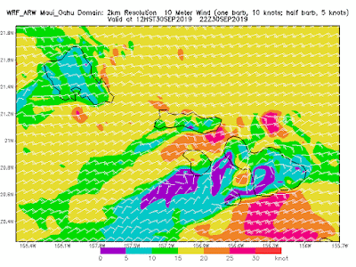
Wind map at noon.

North Pacific only has the windswell fetch.


Moderate fetch (30 knots) in the Tasman Sea will make for a good size swell for Fiji in 2-3 days and a small in Hawaii one in a week.


Morning sky.

Sunday, September 29, 2019

Sunday 9 29 19 morning call

Still waves on the south shore yesterday (with early rain induced onshores in Lahaina), but here's two north shore photos of the day. This is Gofoil's Alex Aguera riding waves at Lanes on his SUP foiling board and a wing. This last one is the reason why I decided to do the surgery for my trigger fingers..


As usual Jimmie Hepp shot the windsurfers at Hookipa, this is a well above average wave. Most other ones in this gallery are half the size.


4am significant buoy readings
South shore
Barbers
2.5ft @ 13s from 205° (SSW)
1.8ft @ 10s from 197° (SSW)
1ft @ 18s from 183° (S)

Lanai
2.1ft @ 13s from 188° (S)
1.3ft @ 5s from 142° (SE)
1.2ft @ 9s from 209° (SSW)
1ft @ 18s from 180° (S)

Couple of feet 13s is what is left of the last S swell, a lot smaller than it's been, but still fun.  This is a double overhead set at Ala Moana that caught everybody by surprise yesterday afternoon, but today the size should be more like waist to head high. Check the Lahaina webcam before going.


Notice also the 1ft 18s reading at both buoys though. That is a brand new long period swell that was not in anyone's forecast. I doubt it will get any big, but it's a nice surprise.

North shore
N
4.9ft @ 9s from 40° (NE)

Hanalei
3.6ft @ 9s from 343° (NNW)

Waimea
2.8ft @ 9s from 358° (N)
1.6ft @ 11s from 327° (NW)
 
Mokapu
3.5ft @ 9s from 52° (ENE)

NW energy down in period, but still lingering, while 9s NE energy from the fetche we've been observing in the last few days adds on top. This mix should keep some waves rolling at Hookipa and the east facing shores, while a longer period small NW bump is expected tomorrow.
 
Wind map at noon.


North Pacific has a N and a ENE weak fetches.


Tasman Sea keeps pumping swells in this remarkable season.


Morning sky.

Saturday, September 28, 2019

Saturday 9 28 19 morning call

I'm running out of words to describe the waves on the south shore, this week has been amazing. Yesterday, between 10 and 11am, in the spot I surfed, every single head and a half set that arrived (and there were many) was a 10. I was happy to just witness such perfection when paddling out or even when caught inside. I almost swallowed water in the duck dives, as my mouth was wide open showing disbelief for what my eyes were seeing. If you've followed this blog for a while, you know I don't give 10's easily.

Brother Mau fly out.


Austin Kalama.


McGregor was packed in the glassy morning, less crowded but a bit choppy around 1pm on my way to work.


Meanwhile, on the north shore the NW swell picked solidly as predicted. Jimmie Hepp has a whole gallery of pictures.


He also took this classic shot of Robby Naish.


2-3am significant buoy readings and discussion.
South shore
Barbers
3.6ft @ 14s from 198° (SSW)
1.8ft @ 10s from 230° (SW)

Lanai
3.9ft @ 14s from 190° (S)
1.1ft @ 10s from 217° (SW)

Period down to 14s, but heights still up in the high threes, today should be smaller than yesterday (when Lahaina had up to occasional double overhead sets), but still solid head high plus. Check the webcam before going.

North shore
NW001
5.4ft @ 10s from 339° (NNW)

Hanalei
4ft @ 11s from 329° (NW)
3.5ft @ 9s from 344° (NNW)

The NW001 buoy has a solid 10s reading leftover from the NW swell (but the NW101 doesn't), but the graph of Hanalei below clearly show that the swell peaked yesterday. It will be smaller today, but probably still fun size. Hard to say without Waimea and Pauwela.


Wind map at noon.


North Pacific has the three fetches in the picture, all pretty weak.


South Pacific has a weak distant S fetch. The yellow one has the usual question mark, 'cause we can't know for sure if it's aiming at us.


Morning sky.


Friday, September 27, 2019

Friday 9 27 19 morning call

Wonderful waves on the south shore also yesterday.


This guy demolished this wave with several bottom to top turn combos like this.


6am significant buoy readings and discussion... bad day to wake up late!
South shore
Barbers
3.9ft @ 15s from 186° (S)

Lanai
4.2ft @ 15s from 190° (S)

Once again we have big numbers at the buoys and that will reflect in big waves in the water. How's this well overhead Impossibles looking set at upper Breakwall? Check out the webcam yourself before going.


North shore
NW101
6.5ft @ 12s from 330° (NW)

Hanalei
9.3ft @ 11s from 316° (NW)

And for a change (for the season), big numbers also at the NW facing buoys (Waimea is down). The local low that is disrupting the flow of the trades is also delivering a nice present for the north shore lovers/lazy drivers. Two fairly different directions, without local buoys now is going to be difficult to predict Honolua. All I can say is that if that energy at the NW buoy really is from 330, there might be waves also up there.

Below is Hanalei's graph that shows a sharp rise (from 3 to 9 feet) from 6pm yesterday to 6am today. From the post Buoys to Maui travel times and Maui's shadow lines we learn that at that period it takes 10-11 hours for the energy to get to Maui, so we should see a similarly sharp rise throughout all day. There's already solid head high waves at Hookipa (that's what they look like on the webcam) and it should get well overhead later in the day. Not sure we'll reach the same 9ft mark though, for the following for two reasons:
1) they get smaller with the extra travel
2) the main energy is missing us to the west, so the most western islands will get more energy than us.


Wind map at noon.


North Pacific has a distant NW fetch, a closeby one and a NE fetch.


South Pacific has a a couple of relatively weak fetches. The one circled in yellow would be stronger, but no idea if it's oriented towards us or not down there. Probably not.


Morning sky.

Thursday, September 26, 2019

Thursday 9 26 19 morning call

Beautiful waves on the south shore yesterday.


4am significant buoy readings and discussion
South shore
Barbers
3ft @ 18s from 196° (SSW)
1.5ft @ 11s from 178° (S)

Lanai
2.4ft @ 18s from 204° (SSW)
1.9ft @ 14s from 194° (SSW)

Big numbers at the buoys equal big waves. Another excellent day ahead. Check the webcam yourself before going.


Here's how Pat Caldwell described the evolution of the fetches.
A pair of systems tracked east SW to SE of New Zealand 9/15-19 aiming energy at Hawaii within 180-220 degrees. The first event filled in locally Tuesday 9/24 and is holding 9/25 favoring 180-190 degrees with 14-16s wave periods. The second event is building 9/25 from 190-220 degrees with 18-22s periods. The second event had much higher seas and a wider fetch in both the southern Tasman Sea and SE of New Zealand. This event should peak on Thursday morning above average.

The jet stream associated with the second event aforementioned become meridional, or south to north, 9/19-20. A cut-off low pressure formed from the sharp meridional trough east of New Zealand 9/20. The surface low pressure jogged from near 45S 9/20 to near 35S 9/21 along 160W. This set up a captured fetch acting upon existing seas from the second event aforementioned. Seas grew to 30 feet. The system weakened 9/22.

The PacIOOS/CDIP American Samoa buoy showed 8-10'@14-16s intervals beginning 9/22 into early 9/24. This energy is expected to fill in locally Thursday 9/26 from 180-190 degrees, adding to the existing event, and making for more consistent sets. The new event should peak near sunrise Friday and hold above average into Saturday morning. The event should slowly drop to below average by Sunday morning from 180-190 degrees. Heights should remain low on Monday 9/30.

North shore
NW101
2.7ft @ 11s from 292° (WNW)

Waimea
1.5ft @ 11s from 314° (NW)

Mokapu
4.3ft @ 9s from 87° (E)

Slivers of NW energy plus the windswell should keep the waves pretty small on the north shore.

Wind map at noon.


North Pacific has a few small/weak fetches.


South Pacific has a nice fetch E of New Zealand. There's going to be a short break of action beginning of next week, but this fantastic south swell season will continue afterwards.


Morning sky.

Wednesday, September 25, 2019

Wednesday 9 25 19 morning call

Photo of the day shows Alan Cadiz with his new "starfish" (with crossed arms, in this case) move on wing and foil. Posted by Gofoil.


3am significant buoy readings and discussion
South shore
Barbers
2ft @ 7s from 176° (S)
2ft @ 11s from 186° (S)
1.8ft @ 15s from 194° (SSW)
1.3ft @ 9s from 194° (SSW)

Lanai
2.7ft @ 6s from 173° (S)
1.7ft @ 11s from 184° (S)
1.6ft @ 15s from 196° (SSW)
1.4ft @ 9s from 198° (SSW)

SW
1.8ft @ 18s from 193° (SSW)

Still a bunch of swells of different period at the buoys, what we care the most is the remaining 15s energy. Notice also some longer period energy at the SW buoy. It's in our waters too, yesterday afternoon Lanai had a 0.7ft 22s reading. It's been a great week on the south shore (hopefully I can start enjoying it, as my jet lag seems to have finally faded) and today should be good too with building size throughout the day (and even bigger tomorrow) . Check the webcam before going.

North shore
Waimea
1.9ft @ 9s from 4° (N)

Mokapu
4ft @ 8s from 78° (ENE)

Not sure about that small N energy at Waimea, also today it should be mostly about the small windswell on the north shore.

Wind map at noon.


North Pacific has mostly the windswell fetch. Notice the low that formed north of us and will be responsible for disrupting the trades flow in the next few days. Clean windless conditions in the morning and hot in the middle of the day.


South Pacific has fetches W and E of New Zealand.


Morning sky shows a rain monster that just developed over Kauai.

Tuesday, September 24, 2019

Tuesday 9 24 19 morning call

Surf shot of the day is this thick lip at the break Cokes in the Maldives. Photo by Madlives Surf Photographer.


Jimmie Hepp was at Hookipa to shoot the windsurfers. Results in this gallery.


6am significant buoy readings and discussion
South shore
Barbers
2.2ft @ 13s from 181° (S)
2.2ft @ 7s from 171° (S)
1.5ft @ 16s from 198° (SSW)

Lanai
2.6ft @ 7s from 177° (S)
2ft @ 12s from 181° (S)
1.5ft @ 16s from 198° (SSW)

Fun long period numbers (although declining) at the buoy with some 12-13s leftover energy. I left the 7s energy too, 'cause yesterday it was clearly present in the lineup (unwelcomed). There's waves also today, check the webcam yourself before going.


North shore
Hanalei
2.1ft @ 10s from 324° (NW)

Waimea
1.6ft @ 11s from 317° (NW)

Mokapu
5.3ft @ 8s from 65° (ENE)

Slivers of leftover NW energy at the local NW facing buoys, also today it should be mostly about the windswell at Hookipa (and on east facing exposures).

Wind map at noon.


North Pacific has a pretty big windswell fetch.


South Pacific has a nice fetch in the Tasman Sea. The black circled part will be blocked by New Zealand.


Morning sky.