Tuesday, February 28, 2023

Tuesday 2 28 23 morning call

Kiter at Hookipa yesterday late afternoon.


Below I grouped the wind maps at noon of January (left) and February (right). You can see how radically different the two months were: heaven and hell if you only surf. March should bring a change with Kona winds starting around the 6th.

My way to enjoy the strong wind is to do wingfoil downwinders, but yesterday's one wasn't particularly fun, as I was mostly worried not get caught on the inside of breaking waves. As you can see from the map below, once I got to Camp One I had to go out to sea much more than usual to avoid double to triple overhead NE breaking peaks. I drew a black circle to show the danger zone. Don't think I'm going to do one today, as the windswell should be even bigger.

6am Surfline significant buoy readings and discussion.

South shore
Lanai

  • 2.6ft
    , 8s, S 175º
  • 0.7ft
    , 17s, SW 215º
  • 0.5ft
    , 13s, SSW 205º

Mix of southerly windswell and small long period SW energies at Lanai. Check the Lahaina webcam if interested, for size, conditions and consistency.

North shore

Mokapu

  • 11.3ft
    , 12s, NE 45º
  • 4.7ft
    , 6s, ENE 70º

NE windswell up to 11ft 12s at Mokapu and that's all we're going to have on the north shore. Home guess for Hookipa and eastern exposures is around head and a half to double and stormy. 

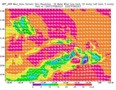
Wind map at noon. The other ones can be found here.


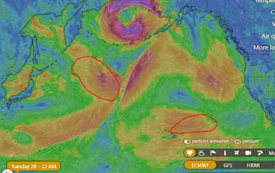
Fetches map (circles legend: red: direct aim, blue: angular spreading, black: blocked, yellow: possibly over the ice sheet) from Windy.
North Pacific (about 4 days travel time from the NW corner of the North Pacific):


South Pacific (about 7 days travel time from east/west of New Zealand):


Monday, February 27, 2023

Monday 2 27 23 morning call

My guess is that Kane sneaked in to catch a wave at Hookipa on one of the many downwinders he's been doing lately. A few days ago I saw him being chased and filmed by a helicopter while he was flying down the coast. Can't wait to see that clip. Photo by Jimmie Hepp from this album.

6am Surfline significant buoy readings and discussion.

South shore
Lanai

  • 2.7ft
    , 8s, S 170º
  • 2.1ft
    , 6s, SSE 150º
  • 0.7ft
    , 18s, SSW 200º

In addition to southerly windswell, Lanai shows 0.7ft of long period energy from 200. Below are the maps of February 21 and 22 that show the fetch that generated it.


Check the Lahaina webcam if interested, for size, conditions and consistency. Definitely some waves today.

North shore
NW001

  • 10.5ft
    , 9s, ENE 65º
  • 3.3ft
    , 13s, NE 35º

Mokapu

  • 7.6ft
    , 8s, ENE 60º
  • 3ft
    , 13s, NE 55º
  • 4.5ft
    , 6s, E 80º

Mokapu shows 3ft 13s of NE energy from the angular spreading fetch I posted yesterday, topped with 7.6ft 8s of additional NE energy. Below is this morning's weather map that shows the intensity of the 1041 mbar high pressure that is sitting to our north. The thing will keep generating strong trades for all this week, before a long due change in the weather pattern should happen in the weekend. As a result, Surfline calls for even bigger easterly windswell, peaking at 13ft 11s tomorrow. That is if I read that forecast correctly... they have a knack for making things worse.


Home guess for Hookipa is head to head and a half and windy. Bigger on eastern exposures.

Wind map at noon. The other ones can be found here.


Fetches map (circles legend: red: direct aim, blue: angular spreading, black: blocked, yellow: possibly over the ice sheet) from Windy.
North Pacific (about 4 days travel time from the NW corner of the North Pacific):


South Pacific (about 7 days travel time from east/west of New Zealand):


Morning sky.


Sunday, February 26, 2023

8am hookipa is head high and blown out. 
2

Sunday 2 26 23 morning call

Hookipa yesterday. Photo by FishBowlDiaries from this album.


Hookipa late afternoon.


6am Surfline significant buoy readings and discussion.

South shore
Lanai

  • 3.8ft
    , 9s, SSE 165º
  • 2ft
    , 7s, SSE 160º

Southerly windswell at Lanai. Check the Lahaina webcam if interested, for size, conditions and consistency.

North shore
NW001

  • 8.5ft
    , 10s, E 90º
  • 5.7ft
    , 7s, E 100º
  • 1.4ft
    , 13s, NNE 20º

N

  • 5.5ft
    , 13s, N 0º
  • 5.7ft
    , 8s, NE 50º
  • 3.8ft
    , 5s, ENE 65º

Mokapu

  • 6.8ft
    , 8s, E 80º
  • 1.9ft
    , 13s, NNE 20º
  • 2.1ft
    , 11s, ENE 65º

13s NNE energy is at the buoys together with the easterly windswell. Below are the maps of February 22 through 24 that show the angular spreading fetch that generated it.


I imagine there will be still some NW energy in the water (but no working local buoys to record it), so today will offer a mix of three different swells. Home guess for Hookipa is for head to head and a half mixed up waves.

Wind map at noon
. The other ones can be found here.


Fetches map (circles legend: red: direct aim, blue: angular spreading, black: blocked, yellow: possibly over the ice sheet) from Windy.
North Pacific (about 4 days travel time from the NW corner of the North Pacific):


South Pacific (about 7 days travel time from east/west of New Zealand):


Morning sky.


Saturday, February 25, 2023

Saturday 2 25 23 morning call

Someone winging up the coast yesterday. Unfortunately I failed to shoot the show that Cash Berzolla put up later in the day in the same spot. The guy is incredible.

6am Surfline significant buoy readings and discussion.

South shore
Lanai

  • 5.4ft
    , 8s, S 170º
  • 0.6ft
    , 13s, SSW 205º
  • 0.4ft
    , 15s, SW 230º

Southerly windswell and smidgets of long period southerly energy at Lanai. Check the Lahaina webcam if interested, for size, conditions and consistency.

North shore
NW001

    • 10.6ft
      , 10s, E 95º
    • 2.3ft
      , 14s, NW 325º

NW101

    • 9.9ft
      , 10s, E 95º
    • 7ft
      , 7s, E 85º
    • 3.2ft
      , 14s, WNW 300º

Mokapu

  • 7.5ft
    , 10s, ENE 70º

The small NW swell is showing at the buoys in line with the forecast, and we can assume there's a couple of feet 14s locally. That'll bring some occasional more organized lines in the head high range, but the ENE windswell will be predominant again. Home guess for Hookipa is head to head and a half peaky mushy windy waves. Bigger on eastern exposures.

Wind map at noon. The other ones can be found here.


Fetches map (circles legend: red: direct aim, blue: angular spreading, black: blocked, yellow: possibly over the ice sheet) from Windy.
North Pacific (about 4 days travel time from the NW corner of the North Pacific):


South Pacific (about 7 days travel time from east/west of New Zealand):


Morning sky.


Friday, February 24, 2023

Friday 2 24 23 morning call

Hookipa yesterday.

6am Surfline significant buoy readings and discussion.

South shore
Lanai

  • 4.7ft
    , 8s, SSE 150º
  • 0.4ft
    , 14s, SW 215º

SSE windswell and a smidget of long period SW energy is at Lanai. Check the Lahaina webcam if interested, for size, conditions and consistency.


North shore
NW001

  • 10.7ft
    , 10s, E 95º
  • 5.2ft
    , 7s, ESE 110º
  • 1.4ft
    , 13s, NW 310º

Mokapu
  • 10.8ft
    , 11s, ENE 60º
  • 4.5ft
    , 8s, E 85º
  • 3.5ft
    , 6s, E 80º

The buoy pandemic got another victim, as Hanalei also appear to be offline today. NW buoy shows a bit of NW energy and below are the maps of February 20 through 22 showing the fetch that generated it (black arrow). Surfline calls for a peak at 2.3ft 15s tomorrow mid day. The blue arrows instead show the windswell fetch and it's easy to understand why that energy is much higher (although shorter period), as we're literally at the end of it and there's not much energy decay due to travel time.


Home guess for Hookipa is the usual (these days) head to head and a third peaky mushy windy waves. Much bigger on eastern exposures.

Wind map at noon. The other ones can be found here.


Fetches map (circles legend: red: direct aim, blue: angular spreading, black: blocked, yellow: possibly over the ice sheet) from Windy.
North Pacific (about 4 days travel time from the NW corner of the North Pacific):


South Pacific (about 7 days travel time from east/west of New Zealand):

Morning sky.


Thursday, February 23, 2023

Thursday 2 23 23 morning call

No photos from yesterday. I shot this video on Tuesday. It's a comparison between two very different foils of similar area. Goes to show how little surface area by itself tells about a foil.


5am Surfline significant buoy readings and discussion.

South shore
Lanai

  • 4.6ft
    , 7s, SSE 150º
  • 0.4ft
    , 13s, S 190º
  • 0.2ft
    , 17s, S 190º

Lanai is recording SSE windswell and smidgets of long period southerly energies. Below are the maps of February 16 and 17 that show the small fetch just east of New Zealand that probably generated the latter.


Check the Lahaina webcam if interested, for size, conditions and consistency.

North shore

Hanalei

  • 8.6ft
    , 10s, NE 55º
  • 2.2ft
    , 13s, WNW 300º

Mokapu

  • 8.9ft
    , 10s, ENE 60º

Hanalei stubbornly keeps showing small NW energy, but once again also today it's all going to be about the raging ENE windswell. Home guess for Hookipa is head to head and a third peaky mushy windy waves.

Wind map at noon. The other ones can be found here.


Fetches map (circles legend: red: direct aim, blue: angular spreading, black: blocked, yellow: possibly over the ice sheet) from Windy.
North Pacific (about 4 days travel time from the NW corner of the North Pacific):


South Pacific (about 7 days travel time from east/west of New Zealand):

Morning sky.