5.4
Monday, January 31, 2022
Monday 1 31 22 morning call
Hookipa yesterday. Photo by Jimmie Hepp from this album.

3am Surfline
significant buoy readings and discussion.
South shore
Barbers is mostly reading NW wrap these days and can't be
used to detect small southerly energy. Check the Lahaina
and Kihei webcam if interested, for size,
conditions and consistency.
North shore
NW101
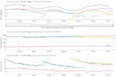
5ft @ 14s from 284° (WNW)
Hanalei
4.6ft @ 15s from 317° (NW)
Waimea
2.7ft @ 15s from 310° (WNW)
2ft @ 7s from 38° (NE)
1.2ft @ 13s from 314° (NW)
1.1ft @ 11s from 336° (NNW)
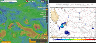
The steady supply of WNW energy continues at the buoys with the previous pulse almost fading out completely, while a new moderate one rises. The latter shows a direction of 284 at the NW101 buoy (309 at the NW001), so it's highly likely that we won't get the whole bulk of it and consequently Hookipa might be pretty small at sunrise only to become slightly bigger during the day. No Pauwela buoy and no buoy graphs on the Surfline page sure don't help the guessing game in these occasions.
Below is the fetch map of Jan 29, which show the fetch from which this new WNW might be coming from. As you can see from the great circle rays map on the right, on this day the fetch was:
- not particularly intense
- between 290 and 300 degrees
- about 2.5 days of travel distance.
The day after it moved north a bit (hence in a less sheltered position) and intensified considerably, so the forecasts predict a decent size pulse for tomorrow afternoon (light blue dotted line on the Pacioos forecast below).

Back to this morning, my home guess for Hookipa is around waist to shoulder high and clean.
Forecast of Pauwela from this PACIOOS page.

Wind map at noon. The other ones can be found here.

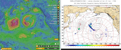
Fetches map (circles legend: red: direct aim, blue: angular spreading, black: blocked, yellow: possibly over the ice sheet) from Windy.
North Pacific (about 4 days travel time from the NW corner of the North Pacific):

South Pacific (about 7 days travel time from east/west of New Zealand):

Morning sky.

Sunday, January 30, 2022
Sunday 1 30 22 morning call
Hookipa yesterday morning.

Hookipa in the afternoon. Photo by Jimmie Hepp from this gallery.

Hookipa late afternoon.

5am Surfline
significant buoy readings and discussion.
South shore
Barbers is mostly reading NW wrap and can't be
used to detect small southerly energy. Check the Lahaina
and Kihei webcam if interested, for size,
conditions and consistency.

North shore
NW101
2.9ft @ 14s from 305° (WNW)
2.5ft @ 12s from 338° (NNW)
1.8ft @ 10s from 348° (NNW)
Hanalei
5.2ft @ 13s from 327° (NW)
Waimea
5.1ft @ 13s from 329° (NW)
WNW swell is noticeably down at the NW buoys but still relatively up at Hanalei and Waimea. That means the decline locally will only be felt in the late afternoon and tomorrow. Home guess for Hookipa is head and a half to possibly double and clean conditions in the early hours.
Forecast of Pauwela from this PACIOOS page.

Wind map at noon. The other ones can be found here.

Fetches map (circles legend: red: direct aim, blue: angular spreading, black: blocked, yellow: possibly over the ice sheet) from Windy.
North Pacific (about 4 days travel time from the NW corner of the North Pacific):

South Pacific (about 7 days travel time from east/west of New Zealand):

Morning sky.

Saturday, January 29, 2022
Saturday 1 29 22 morning call
Hookipa yesterday late afternoon. The new swell hadn't really filled in, but there were little sets like this.

Yesterday morning the waves were very small but with wonderful lack of wind, so I went for a Foil Drive sesh. This clip taken by Tomo shows me taking off on a small unbroken wave.
4am Surfline significant buoy readings and discussion.
South shore
Barbers is back to reading NW wrap and can't be used to detect small southerly energy, check the Lahaina and Kihei webcam if interested, for size, conditions and consistency.
North shore
NW101
7.1ft @ 15s from 310° (WNW)
Hanalei
5.4ft @ 15s from 313° (NW)
Waimea
3.3ft @ 15s from 310° (WNW)
New WNW swell peaked at the NW101 (graph below on the left) and is still rising at the other upstream buoys down the island chain. On the right below is the Surfline forecast which seems to be a bit early time wise. Home guess for Hookipa is for head high (possibly plus) to start the day with and then increasing all day. Sunset should be solid double overhead.

Forecast of Pauwela from this PACIOOS page.

Wind map at noon. The other ones can be found here.

Fetches map (circles legend: red: direct aim, blue: angular spreading, black: blocked, yellow: possibly over the ice sheet) from Windy.
North Pacific (about 4 days travel time from the NW corner of the North Pacific):

South Pacific (about 7 days travel time from east/west of New Zealand):

Morning sky.

Friday, January 28, 2022
Friday 1 28 22 morning call
Hookipa yesterday morning.

Hookipa yesterday afternoon.

Referring to his quest to make prone foiling DW easier, Dave Kalama just posted a little video that had these words in the description: "Being challenged to find creative solutions, sometimes failing, sometimes succeeding, but always evolving and getting better. That’s where the real gold is."
You can apply that to everything. For example, I just elevated my roof racks of about one inch in order to be able to put a longboard underneath them and make room for another board inside. The system worked, but introduced one little annoying vibration from the bags. After a couple of failed attempts to locate it and fix it, yesterday I mounted the Gopro on the roof and drove home like that. The vibration is now spotted and I know how to fix it.
This is a shot before I left from the kite beach parking lot, where yesterday I had two SUP foiling and one wave winging session (about four hours on foil). Had someone told me a few years ago that I would spend a whole day there, I would have not believed it...

4am Surfline
significant buoy readings and discussion.
South shore
Barbers
0.7ft @ 20s from 193° (SSW)
Thanks to the lack of strong NW energy, Barbers can register small long period SSW energy. Below are the maps of Jan 21 through 23 that show the fetch that generated it. A fairly strong one, but aiming to our east, so we're only getting the angular spreading of the swell. That, together with the long journey, will make the arrival of the sets particularly inconsistent.
Check the Lahaina
and Kihei webcam if interested, for size,
conditions and consistency.

North shore
Hanalei
2.4ft @ 11s from 297° (WNW)
0.6ft @ 18s from 356° (N)
Waimea
1.9ft @ 9s from 343° (NNW)
1.7ft @ 12s from 300° (WNW)
1.6ft @ 11s from 316° (NW)
0.5ft @ 20s from 298° (WNW)
Kaneohe Bay
2.3ft @ 8s from 55° (ENE)
Hilo
4.2ft @ 9s from 61° (ENE)
Transition day. The old WNW energy is definitely winding down at the upstream buoys, suggesting the smallest day since the beginning of the year. It's going to be a brief pause though, as a new long period NW swell is already showing with tiny readings at Hanalei and Waimea. The Pacioos forecast two pictures below shows this new swell in light blue and peaking tomorrow at around 5.5ft 15s from 315 (same values as Surfline).
Below are the maps of Jan 26 to 28 that show the fetch that originated it. Home guess for Hookipa this morning is chest to head high and clean. Bigger at sunset.

Forecast of Pauwela from this PACIOOS page.

Wind map at noon. The other ones can be found here.

Fetches map (circles legend: red: direct aim, blue: angular spreading, black: blocked, yellow: possibly over the ice sheet) from Windy.
North Pacific (about 4 days travel time from the NW corner of the North Pacific):

South Pacific (about 7 days travel time from east/west of New Zealand):

Morning sky.

Thursday, January 27, 2022
Thursday 1 27 22 morning call
Hookipa yesterday morning.

Kanaha yesterday mid day. The kitefoiler was going three times faster than everyone else. He's on an Armstrong mast, if someone knows him and can ask him what front and tail wing he was using and then let me know, I'm very curious. Comment on this post or email, thanks.

4am Surfline significant buoy readings and discussion.
South shore
Barbers is mostly reading NW wrap these days and can't be used to detect small southerly energy. Check the Lahaina and Kihei webcam if interested, for size, conditions and consistency.
North shore
NW101
4.2ft @ 12s from 322° (NW)
3.8ft @ 10s from 7° (N)
Hanalei
6.1ft @ 13s from 308° (WNW)
3.1ft @ 9s from 4° (N)
Waimea
4.6ft @ 13s from 321° (NW)
Hilo
3.4ft @ 8s from 87° (E)
Kaneohe Bay
3.2ft @ 8s from 64° (ENE)
WNW energy continues to show at the buoys. It's been hard to identify the end of a swell and the start of another, as there's always been fetches WNW of us, pretty much from the beginning of the year. The fact that the Surfline buoy page doesn't offer the graphs of the individual buoys anymore (with the exception of the NW101) doesn't help. Below are the maps of Jan 22 through 25.

Hanalei has the biggest reading, not sure if Waimea (and afterwards Maui) is going to rise too in the next few hours. Home guess for Hookipa is for head to head and a half and clean. Please understand that, due to the prolonged absence of Pauwela (no news about that), these guesses can easily be a bit off at times.
Forecast of Pauwela from this PACIOOS page.

Wind map at noon. The other ones can be found here.

Fetches map (circles legend: red: direct aim, blue: angular spreading, black: blocked, yellow: possibly over the ice sheet) from Windy.
North Pacific (about 4 days travel time from the NW corner of the North Pacific):

South Pacific (about 7 days travel time from east/west of New Zealand):

Morning sky.

Wednesday, January 26, 2022
Wednesday 1 26 22 morning call
Hookipa yesterday afternoon. Photo by Jimmie Hepp from this gallery.

4am Surfline
significant buoy readings and discussion.
South shore
Barbers is mostly reading NW wrap these days and can't be
used to detect small southerly energy. Check the Lahaina
and Kihei webcam if interested, for size,
conditions and consistency.
North shore
NW101
5.2ft @ 12s from 307° (WNW)
Hanalei
4.9ft @ 13s from 296° (WNW)
Waimea
5ft @ 13s from 309° (WNW)
Hilo
4.7ft @ 9s from 79° (ENE)
Kaneohe Bay
3.6ft @ 9s from 62° (ENE)
WNW energy is still at the buoys declining both in size and period. Home guess for Hookipa is head to head and half. Decent ENE windswell will give eastern exposures some waves too.
Forecast of Pauwela from this PACIOOS page.

Wind map at noon. The other ones can be found here.

Fetches map (circles legend: red: direct aim, blue: angular spreading, black: blocked, yellow: possibly over the ice sheet) from Windy.
North Pacific (about 4 days travel time from the NW corner of the North Pacific):

South Pacific (about 7 days travel time from east/west of New Zealand):
Morning sky.

Tuesday, January 25, 2022
Tuesday 1 25 22 morning call
Hookipa yesterday afternoon. Photo by Jimmie Hepp from this album.

After a lovely wingfoil session, I was chatting with my friend Randy when I got a report of good wind conditions in Kihei. I went home to get my Foil Drive and off we went for a delightful downwind run. This is the short video I made of it.
6-7am Surfline
significant buoy readings and discussion.
South shore
Barbers is mostly reading NW wrap these days and can't be
used to detect small southerly energy. Check the Lahaina
and Kihei webcam if interested, for size,
conditions and consistency.

North shore
NW101
8.4ft @ 13s from 309° (WNW)
3.7ft @ 10s from 332° (NNW)
Hanalei
5.9ft @ 13s from 310° (WNW)
3.9ft @ 10s from 41° (NE)
3.5ft @ 11s from 333° (NNW)
Waimea
6.5ft @ 13s from 311° (NW)
1.6ft @ 11s from 323° (NW)
Hilo
6.4ft @ 9s from 74° (ENE)
WNW energy continues relentless at the buoys. Home guess for Hookipa for head and a half.
Forecast of Pauwela from this PACIOOS page.
Wind map at noon. The other ones can be found here.

Fetches map (circles legend: red: direct aim, blue: angular spreading, black: blocked, yellow: possibly over the ice sheet) from Windy.
North Pacific (about 4 days travel time from the NW corner of the North Pacific):
South Pacific (about 7 days travel time from east/west of New Zealand):

Morning sky.

Subscribe to:
Posts (Atom)


