Saturday, February 28, 2015

Scattered chest to shoulder high weak peaks.

2 28 15 morning call

This is the idyllic vision you had if you were at the right spot at the right time yesterday. Photo by  Jason Hall.


The size was much more friendly than the day before, which saw some DOH sets, even though someone using the hawaiian scale called it 3 to 4 feet.
I hope I won't offend anybody, but as long as I'll have this blog I will never use the non sense Hawaiian scale.
And I'm gonna spend a few words on this.

The Hawaiian scale measures the waves from the back. The day I'll see someone surfing the back of the waves, that will make sense, but since then it's a complete non sense.
I know there's historical reasons why it got adopted, but I could not care less about those. Things change and we move forward. I do.

That day the buoy read 9f 10s from around 70. That's the sizes I use on this blog.
Once such a swell hits a surf spot, the size of the actual waves can change a lot depending on the spot and its orientation. So if someone asks me how big the waves were at that particular spot, I always use body parts, because that cannot be confused. If one says shoulder high, it's immediately clear that he's talking about the face of the wave, not the back!

So for me that 3 to 4 foot day was head and a half with occasional Double Over Head (DOH) sets. I got two of those on the head and they pushed me so far back in that I had to get out of the water and walk to a better launching spot to make it back out.
Fortunately I know what most of my friends mean when they use the Hawaiian scale.
3 feet can mean anything from shoulder high to almost DOH, depending on who says it.
So I have to remember what are John's 3 feet, Michelle's 3 feet, Jason's 3 feet, etc...
It's ridiculous, it offends my brain and that's the reason for this rant.
Thanks for reading, maybe someone will be convinced to abandon it thanks to it.

Today.
Pauwela buoy reads 5.2ft @ 10s from 65° (ENE) and that's all there is. I'll post a photo from Hookipa shortly, which is going to be smaller than yesterday since yesterday it was more like 7.5f 10s, right?


This is the wind map that shows a couple of fetches and some bad northerly winds approaching.


There's also some clouds over the islands (the tail of a front), as shown by this 6.30am satellite photo.


And some rain.
 
Have fun (not) in the sun everyone!


PS. All the sources for this post are permanently linked in the links section on the right of this blog.

Friday, February 27, 2015

Waves are weak, lineup is crowded and Elliott got some weird camera gear for a shoot

2 27 15 morning call

Yesterday's surfing photo from Hookipa is from Jimmie Hepp and shows legendary Ilima Kalama ripping at age 72 (or maybe more).


I'm inspired by the dad just as much as I'm inspired by the son (Dave) and I'm gonna share a stupid secret plan that I have.
If I ever make it to age 75, I wonna be the best 75 years old surfer on the planet. That means that the competition will be between me and all the other class 1963 surfers still out there. I might even have to organize a contest...
Robby Naish was born in that year. Good luck to me!

This morning no graphs, just the Pauwela buoy 7am reading:
7.7ft @ 10s from 79° (ENE)
That is a fairly big windswell you guys. Did you notice it in yesterday's call? Hookipa looked fun, but crowded as usual. Instead I surfed a spot that I'm gonna call 3B's because it was Big, Beautiful and Blue.
Crazy amount of paddling though... windswells are very consistent, because they are closely generated.

Wind map shows promising fetches, we'll see how those will develop. In the meantime, it's all about the ENE windswell and today the wind will be very light.


Have fun in the sun everyone!


PS. All the sources for this post are permanently linked in the links section on the right of this blog.

Thursday, February 26, 2015

Pure windswell still glassy at 11am, but some texture is coming.

2 26 morning call

Windsurfing photo from yesterday from Jimmie Hepp still shows some head high waves.


Surfing photo from yesterday shows some waves in Kihei too. I'm gonna guess head high too.


No graphs today, everything is going down, you can check yourself with link n.11
5am main swell buoy readings:
NW
4.9ft @ 10s from 287° (WNW)
3.8ft @ 12s from 286° (WNW)
1.9ft @ 5s from 67° (ENE)

Waimea
4ft @ 13s from 292° (WNW)           
2.1ft @ 8s from 25° (NNE)
2.7ft @ 10s from 327° (NW)

Pauwela (indicative of what's in the water on Maui's north shore)
8.2ft @ 9s from 70° (ENE)
4.2ft @ 13s from 323° (NW)

West lanai Maui north shore (indicative of what's in the water on Maui's south shore)
3.1ft @ 13s from 253° (WSW)           
1.2ft @ 9s from 222° (SW)
 
1.1ft @ 6s from 171° (S)

At Hookipa is going to be mostly about the windswell. The good news is that at 6.30am there's not much wind yet.


According to the NAM model there shouldn't be much also for the rest of the day, but look how different the HRW model is. We'll see which one is right.

   
The wind direction will be a little more east than yesterday and the two fetches we have today are both weak.


The weather is about to get pretty bad, so have fun in the sun everyone now that there's still some!

PS. All the sources for this post are permanently linked in the links section on the right of this blog.

Wednesday, February 25, 2015

Had to wait quite a bit before that head high set hit the point. Before that, only windswell. Windy, bit rainy, kinda cold. Could be better, could be worse.

2 25 15 morning call

Windsurfing shot from yesterday to start the call. Sailor: Morgan Noireaux, photog Jimmie Hepp.


Before I get into the call, I'd like to share this flyer that has been seen at Hookipa. A 23yo german surfer died and his mom came all the way here because his son watched a surf movie from Hawaii in which they did a paddle out for a fellow surfer. He was very emotionally touched and told his mom about it. And now she's here looking for surfers for a paddle out for him. Gonna happen this morning, Wednesday 25 at 8am.


Buoys are interesting this morning. These three are NW, W and Waimea. The first two show a significant rise up to almost 8f. The third is not showing much of that.


These other two are Pauwela and Lanai. No sign of that rise either. What do you guys think? Where did the swell go? All dissipated into refraction?
I think it's gonna get bigger today...
Too bad there's wind and windswell (6f 8s) to ruin it. Another good day for wind related sports though.


Another relatively bad wind map. Not much energy generated towards us. Where that low is, there will be some bad weather all next week. NE wind, rain and medium/short period waves. Not good.
Not complaining, just reporting, that's my duty.
 
Have fun in the sun everyone!

PS. All the sources for this post are permanently linked in the links section on the right of this blog.

Tuesday, February 24, 2015

2 24 15 morning call

Sorry for the late post, knowing the forecast, I chose to sleep in...

Quick Jimmie Hepp photo from yesterday to start with. Lots of sailors at Hookipa, they've been starving for months.


As the buoys show, there was not much on offer this morning. Below is NW and Waimea, and the first one is reading 5f of the new WNW swell (remember that nice fetch we saw the past few days?).
Only 2.5f at Waimea and I circled the areas that would seem correspondent in the two graphs and I also continued the Waimea graph into the future. That's how it would be IF... the swell was hitting Waimea directly! But it's most definitely not (the direction at the NW is 280!).
So I have no idea of how big it is going to be. The ww3 model (and similar) do and they say 4f 12s but only tomorrow. Same for Maui.


Below is Pauwela and Lanai, both reading about 1.5f 15s. Notice the extremely different directions (319 vs 266). And yet, that is the same swell. One part of it is wrapping around the island chain from the north, the other one from the south. Pretty amazing, really.

Wind maps are starting to show signs of the winter slowing down. That is the toughest part of the year for me. March is knocking on the door and I absolutely hate that. Only two insignificant fetches aiming at Hawaii today, that means that we're gonna have some really small days ahead. Particularly the weekend.

 
 Fortunately when one ocean goes to sleep, the other wants to wake up.
Below is the south pacific maps of Feb. 14, 15 and 16. I circled a little fetch that wasn't that strong at all, but nonetheless is causing Surfline to predict 1.8f 14s from the south today, tomorrow and thursday. Seems like a really weak forecast, but it won't be flat. Maui's south spots need much more than that to go off.
The threshold is right there at 2f 15s. Anything under that, Waikiki can still be waist to chest high and Maui gets ankle to knee. One main reason for that: Kahoolawe.

I'm also posting today's map from downunder to show that fetch that I talked about a couple of days ago. I have very low expectations on that one, since it's really sending its energy to central America rather than us. The angular spreading will allow inconsistent long period lines to arrive around Monday/Tuesday and those should be above that threshold I just mentioned.

Ah, if I had the luxury of the webcams when I do my call at the normal time!
Hookipa to the left and Lahaina to the right show small waves, but not flat.


To summarize today's prediction: trade winds will be blowing and the WNW swell will be slowly peaking up all day, but the biggest day should be tomorrow.

Have fun in the sun everyone!


PS. All the sources for this post are permanently linked in the links section on the right of this blog.


Monday, February 23, 2015

Small and a bit windy. This a shoulder high one at pavils.

2 23 15 morning call

The trades are back, so are the windsurfers at Hookipa.
Here's my favorite sailor Levi Siver in a photo from Jimmie Hepp.

As you can see from the photo above, there were still plenty overhead sets yesterday with 5f at the buoy. As the graphs show (first one below is NW and Waimea), everything is going down, so expect smaller sizes today.


These two are Pauwela and Lanai. They still have 4f 12s and 2f 13s so there should be something to play with on both shores.


Not the most exciting wind map. Just a little fetch WNW of us. We will have some small days towards the end of the week, after a moderate WNW swell peaking on Tuesday created by that same fetch that yesterday looked a lot better.

More wind for the wind passionates. This map is the noon one.

Have fun in the sun everyone!


PS. All the sources for this post are permanently linked in the links section on the right of this blog.

Sunday, February 22, 2015

Head high+ and poor shape.

2 22 15 morning call


Here's two things I can say about yesterday: if you surfed Hookipa, you sure had a workout (that's what it looked like), but you might have enjoyed the lack of crowd, specially after one of the most crowded days of the year (that was Friday).
If you surfed the south shore with a longboard, you had a blast. West wrap was filling in some spots at solid waist high and it was glassy all morning.

Today's buoy readings show a still healthy 5f 13s in Maui, hopefully a little less work at Hookipa, but since the trades are trying to blow, it's not gonna be clean.
Here's the graphs.
I put a line on the peaks of the swell on the three buoys, so that you can appreciate the travelling time.
If you don't want to get too precise, I also circled the part of the NW buoy graph that you want to look at to have an idea of the swell is going to do in Maui during the day.
The other way would be to look at the Surfline forecast, which is extremely accurate.
Either way, you can see how the waves will go down today. But not that much, maybe a foot at the buoy.


Wind map shows a lovely little fetch in a really good position. Not too far, not too close, not too strong (not a fan of the XL swells), not too weak.
The low associated with it is going to try to push to the east the high that is temporarily creating the trades. As a result, in the next few days we should sit in the area that I marked with an X and that will give the trades a very easterly direction.
I don't mind that at all, since most days like that you have glassy conditions in the morning and light sideoff trades in the afternoon.


Today (and this morning) trades are sideshore though and that means plenty chop on some otherwise beautiful waves.
It's not that I don't like windsurfing. I just don't like chop on the waves.
The MC 2km map at noon confirms that wind direction. But it's a Sunday, hundreds of windsurfers and kitesurfers have been waiting for a day of trade for a looong time, so I hope Kanaha and kite beach will be packed with colorful sails and everybody will have a blast.


That'll be it for today, but let's pump some frothiness.
Here's what Dr. Hall posted on FB yesterday tagging me:"3' @ 18 sec. from 170 deg (SSE). Just saw it on the 10 day forecast. Visions of shoulder high noserides come to mind."
Here's what I commented:"the website I check every day for the south swell gives just a couple of days of future modelled weather map, but with a nice resolution around New Zealand.
Then I have the 14 days Surfline Maui south shore forecast, but I don't check that often in wi
nter time.
In other words, you found out before me! You're gonna be on tomorrow's morning call!!!"


That is weather map that is modeled for this coming Tuesday. Fetches in that position down there usually generated swells that take around 7 days to reach us, so think about Monday/Tuesday in 9 days".
Keep also in mind that south swells never last only a couple of days, because since they travel so long, they also spread out a lot, with the long period waves arriving days before the medium and short ones.
That particular swell is gonna miss out to the east, but we're gonna get the angular spreading (provided that the models are right and that fetch is gonna materialize) and that means a SSE direction and a little more inconsistent than what south swells normally are.
But it might hit parts of the island without much block from lovely Kahoolawe, so... if you guys really wonna be excited about it, I give you permission.
But I'm not. Not in winter time.


Have fun in the sun everyone!


PS. All the sources for this post are permanently linked in the links section on the right of this blog.

Saturday, February 21, 2015

Hookipa big and messy

2 21 15 morning call

The photo below shows Yuri Soledade (one of my favorite Maui surfer and Peahi charger) bottom turning on a beautiful wave at Hookipa yesterday morning.


In fact, there were some beautiful waves thanks to the light kona wind. The problem (with my session, at least), was the vast amount of people (due to the not scary size and long lulls between sets that allowed anybody to paddle out) and the inconsistency (due to the wrap).

When it's like that, surfing sucks. Everybody is starving for waves and when a set finally arrives, everybody turns around and paddle and of course the deeper guys will claim priority and they won't make the section and in the end nobody has fun.
I launched at Middles and it was horribly crowded; went to Lanes, same; went all the way down all the breaks past that, same. Well, at least I got a nice paddling workout.
FORTUNATELY, the onshore wind picked up around 11 and at that point I was forced to drive to the other side of the island for a second session. That was a blessing from the sky, because I ended up scoring a solo longboard session on a waist high very soft wave that was about 100 times more fun than Hookipa.

Today's buoys. The NW is on the left, Waimea on the right. I put two arrows to indicate the change in direction that the swell has had at the NW buoy. From around 276 to 296 in a couple of days. The effect of that is going to be extremely clear when we look at the Lanai and Pauwela buoys below.


See the big increase at the Pauwela buoy, but not at the Lanai one? That's because the swell is now coming more from the north and it doesn't require to wrap as much to hit the north shore.
I put two arrows to indicate how the direction at the Pauwela buoy did not change at all. It doesn't matter where the the WNW swell is coming from for that. The direction will always be around 320. Once again, you're never gonna see a swell coming from 300 or less at the Pauwela buoy, unless a meteor falls in the water outside the Kahului harbor.

What changes, is the size and the consistency. The more north in a WNW swell, the bigger and more consistent it will be on the north shore. Actually, once you pass 320 (as the original swell direction!!), there is no much difference, because there is no refraction. At least Hookipa gets hit straight after that. Kanaha and Honolua have different exposures and will feel the change of direction past that.


The wind map shows one main fetch WNW and a tiny one N of us. It also shows a mini high pressure cell that, once it moves a bit to the east, will bring back the trade winds.
Windsurfers and kitesurfers from all over the world have been waiting eagerly for this.
Can't even remember when was the last time I sailed with the trades. It's been a really good winter for surfing so far...


That means that today's surfing on the north shore, despite the noticeable increment in size, will be highly effected by the wind. Below is the MC 2km map at noon, but the 7am one looks just the same.
How do youthink the waves are going to be today on the north shore?
Correct, they're gonna be shit. Sorry if I'm pretty drastic, but that's what it is, specially considering how pristine the conditions have been so far with the light offshore or calm days.

 
Go surf somewhere else or just stick to the wind related sports (which might happen already today, you would think looking at that map) is my suggestion.


Whatever you choose to do, have fun in the sun everyone!

   
PS. All the sources for this post are permanently linked in the links section on the right of this blog.

Friday, February 20, 2015

Saw an overhead set at middles from the highway and dont feel like waiting for another one because it might be a while. I forgot to write in the call that west refracted means low consistency. Clean light offshore.

2 20 15 morning call

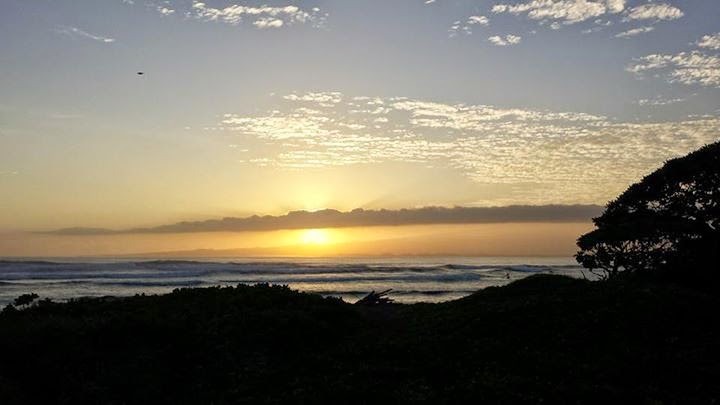
Small but clean = fun.

That sums up yesterday morning and these two couple of shots of water photographer Jason Hall help reinforce the concept.


The other day I replaced the wetsuit compartment (sounds better than cardboard box) in my car and... I have way more than the 8 wetsuits I claimed I had. Didn't count them but it's more like 12, really...

Just think about this: the thicknesses that make sense for me in Hawaii are .5, 1, 1.5 and 2mm.
The styles are: tank (or no sleeve) top, short sleeve top, long sleeve top, no sleeve spring suit, short sleeve spring suit, long sleeve spring suit.
That is a total of 24 different combinations, so I actually don't have all that many...

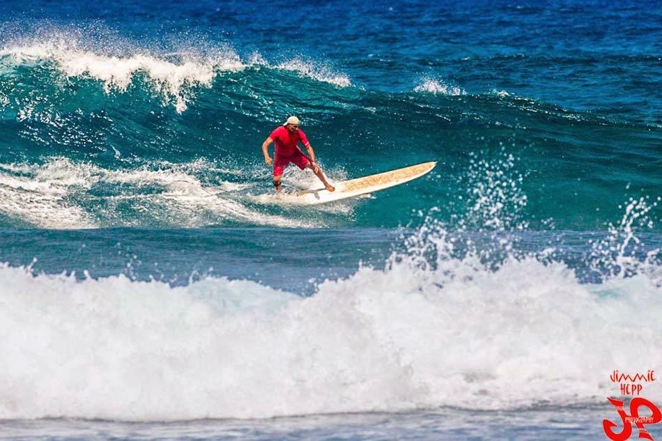
The one I'm wearing in the photo below is a Xcel Drylock 2mm top and it's my favorite top.
The seams are sealed and until the first wipeout, I don't get a single drop of water in it. Very nice features when paddling out in these cold offshore mornings... what a blessings these last ones, btw!

It is extremely light and also when wet it stays lighter than my other 2mm tops because it doesn't absorb as much water. The constriction is pretty much inexistent and I have no extra material under my armpits (which is the reason I discard half of the tops I try).
The trick (as for any other wetsuit) is to buy one that fits you really tight. For this particular one, I picked a Small size, while I usually wear a Medium. It just fits me perfectly and even though I could use a cm or two of length more, it's still much warmer than a longer but less tight Medium.

We have a couple of Medium and a Large at Hi-Tech in Kahului, btw. If you go there and buy one because you read it here, please make sure to tell Tyler about it.
I'm not sponsored by Xcel (yet!), but I like their suits so much that I feel like recommending them.
My other two favorites are the 2mm Infinity spring suits (both short and long sleeve in size M).
 
 
Today's call is made easy by the wind. First the buoys though.
Below are the graphs of the NW and the Waimea ones. Notice how the NW went up like 3 feet in 6 hours just before midnight and it's not recording close to 10f.
Now, if the direction of the swell was around 310, we could expect the same to happen to the Waimea one, roughy around the two arrows I added. But in this case we have no guarantee that it will happen like that.
Oh btw, when I say you have to click on the photo to appreciate the details, it's mostly so that you can read the latest reading up in the left top corner. Even though I know it's hard to do that on a mobile phone, I'm gonna leave that to you to figure out. Read this blog at home from the computer before you go surf, that's my suggestion...


Next buoy graph combo is: West Hawaii, Lanai and Pauwela.
As I repetitively affirmed yesterday, because of the swell direction, the Lanai buoy is getting hit in a much more direct way than the Pauwela: 4f vs 2f.


The W buoy is recording 6f 15s (it doesn't give the direction). and since we're kind of in the middle (latitude wise) between NW and W buoys, we can try to do an interpolation between those two readings to understand what's coming at us. Here's another map that shows the position of all the outer buoys.
Some inappropriate names there. N should be NE, W should be WSW, SW should be SSW, but I guess I'm too precise.


The wind map shows a couple of lovely fetches and the approaching of a front that, as usual, will have a important role on the local wind and conditions.


 Here's the 5.30am satellite picture that shows the front over Oahu.


It might bring some rain with it, as the 6am radar image shows.


So what time is the wind gonna change in Maui? MC 2km hasn't updated their maps yet, so we look at Windguru. The two models disagree (they always do). The NAM (which was right yesterday about the strong and sailable kona) says around 4-5pm, the HRW says around noon. Looking at the satellite picture, and considering I start working at 2 today, I'm gonna say that the wind will switch from SW to NW at exactly 1.30pm... so I don't have to drive to other side!
Yes because even though there might be more energy in the water in Kihei, the direction of the wind make the call easy as I was saying before: with the kona wind, you surf the north shore. Once it switches, then it's a completely different game, but I'll be at work... you guys enjoy the hunt and...


Have fun in the sun everyone!


PS. All the sources for this post are permanently linked in the links section on the right of this blog.