Sunday, October 31, 2010

940

That's a hell of a storm, but it's in the "wrong" place and it will move away from us.
I think wave models are over estimating the size in Hawaii.
Not that it makes too much difference for me if it's extra large instead of giant...


Maui, what a place!
Yesterday was supposed to be light wind and small waves.
Instead Hookipa was totally sailable and plenty overhead sets. Just the usual 40 really good guys out.
I waited till 4pm and around 5pm there were finally only 4 sailors out. That's when the surfers come out though, so you have to let them have their share too.

My last wave was a logo high bomb that caught all the surfers too far inside. Only one, my buddy Tim, was in position on the shoulder right in front of the rocks.
He paddled like crazy for it, while I was watching from the peak and couldn't stop a big smile when I saw he missed it...
Thanks Tim, I hope you got plenty more after that.
That wave did not go wasted! :)

Saturday, October 30, 2010

big swell update

WARNING: this is an extremely boring forecast post.

Here's what Pat Caldwell posted on Friday afternoon:


Models are showing the jet stream amplifying a trough between the longitudes of the dateline to Hawaii this weekend. A weak low pressure from the subtropics near Japan is tracking rapidly toward the dateline on Friday. This tropical moisture will be a critical parameter in the forecast of radically dropping central low pressure values, which are expected to reach to 940 mb late Saturday. Hurricane-force winds are expected near the center, to 75 knots. The brunt of this modelled swell is aimed at targets NE of Hawaii. Over a wider area severe gale to storm-force winds are modelled to stretch from near Kamchatka to well east of the dateline, covering a fetch over 1000 nm long. Models show a long duration to the fetch. These aspects are the essential ingredients for creating exceptionally high long period swell. The nose of gales with seas to 30 feet is expected to reach to 1000 nm of Hawaii by late Sunday. Proximity of high seas is one of the important sources for winter-caliber surf in Hawaii. More explicit expectations can be provided after the pattern unfolds and estimates of surface level winds and seas are available. In any regards, consistency among models and model runs over the past 72 hours give credence to this event.

The local surf is expected to ramp up rapidly around sundown on Monday from 320-350 degrees. The episode is expected to peak mid day on Tuesday in the extra-large to marginally giant category, meaning significant breakers on outer reefs.


Well, I went to check the models on Saturday morning and honestly it seems that yes, a very big swell is about to be generated, but it will heavily miss Hawaii to the NE.
We'll get the angular spreading and that's always tough to forecast. Anyway, if all the models are forecasting big waves (16 feet, 16 seconds from 350 by sundown Tuesday on Surfline), I guess we'll receive big waves.

Warning for all the pro windsurfers that are in Maui and are thinking about changing their tickets to Cabo Verde to have the opportunity of sailing Jaws: don't do that!
It's pretty clear by now that there will be no wind to sail on Tuesday anywhere on the NORTH SHORE. Thursday should be windy (although from an initially onshorish direction) and there will still be waves around, but no wind on Tuesday.
Repeat: no wind on Tuesday. So don't change your tickets and get the hell out of here! :)

I'm just kidding. Like everything, the presence of all the pros has good and bad aspects. Good: incredible show and picture opportunities; bad: crowded as hell.

The good news is that after the big one, I can see two more storms lined up. They all will have fetches oriented towards the mainland west coast, but that's good news for the windsurfers, since that means that there will be a trade wind generating high pressure above us. In other words, after Thursday there should be wind and waves for a while.

Sorry about this dreadful post with no pictures. Let me make it even worse, by typing my frustration for yesterday's missed session.
Got to Hookipa at 3 and looked like heaven. Light wind and big peaky waves up to logo high. By the time I rigged, the wind dropped to almost nothing. Waited a bit and then decided to check Kanaha. Lowers was smaller than I expected, and I thought to wait for the evening glass off for a SUP sesh. By 5 it was clear that the light wind was not going to die and, so I rigged and sailed out to catch two waves.
Not big enough, not quite enough wind. Went back in, paddled out on the SUP around 6.15, caught one wave and paddled back in almost at dark.
I should have just taken a day of rest, but after seeing those awesome conditions at Hookipa, I was so ocean aroused that I had to get in anyway... some of you will understand.

Friday, October 29, 2010

finally light wind and sunny!

What a beautiful day to be off yesterday was!

After a few days of rainy weather and strong gusty winds, yesterday it was sunny and the wind (still very offshore) was light.
A 2 feet NNE ground swell snuck under the radar and together with a 8 feet windswell provided some fun waves to slog and surf.
I went out around noon when the wind was super light and for an hour it was just me and Nick Warmuth sharing waves. Each time it probably took us something like 10 minutes to slog out and get in position again, but at least there was no competition and the waves were absolutely glassy.
No surfers either, since the early morning had been way windier.

Then the wind picked up a bit (but still slog and surf) and 20 more windsurfers came out. A little more power in the sail to crank the turns, but more people to compete for the waves with.
On one I had Kevin Pritchard upwind and Robby Naish downwind and I asked myself:"and now, what do I do?"
I got out of their way, that's what I did.
Anyway, happy after a two hours session, I went for lunch and photoshoot, and then I went out again in the late afternoon for a couple more waves. Francky was in the water and as usual he took some amazing shots that can be admired in this gallery.

Moi.


This shot shows the two Ultra Light (made out of a dacron like the kites' one) custom panels of my Maui Edition 4.7 Superfreak. It also has a extra light mast sleeve (not a good thing if you break the mast) and yesterday I rigged it on a 370 with 34cm extension. I think I like it better on the 400 bottom - 370 top combo that I normally use, but I could definitely feel (and love) the lighter weight of the rig.
I think that's the lightest 4.7 on Earth. For sure the softest and most comfortable. I just love it.


Here's my photos in chronological order.

US1111.


Philippe.


Bunch of celebrities in this one: Robby chats with Michi Schweiger while Mark Angulo gets out of the water and Boujmaa enters it.


Peculiar bikini (check the top).


Slightly megalomaniac.


Boujmaa.


Manna.


Robby.


Michi broke the mast.


This is the surfline 5 days forecast. At 16 feet, 15 seconds from around 340, Jaws should be quite big Tuesday afternoon. High tide will be around noon, but that is one spot where I have no idea what the tide does. Probably not much with such a big swell...


Last but not least, ladies and gentlemen, here's Dax, a cute little bugger that knows how to plane at age 7.


6am. The damn wind is already on it, I'm going to check the surf anyway.

Thursday, October 28, 2010

a new traffic hazard called Boujmaa

The wind yesterday at Hookipa was horribly strong and gusty.

The sailors who jump (pretty much everyone but me) were able to make the most of these dreadful conditions.
Getting out of the car after having parked at Hookipa, I saw Boujmaa going for a huge double forward. He went so high, that a tourist car on the highway stopped to watch and the cars behind went heavy on the honk...

I'm telling you, these days the Hana Highway is even more dangerous than usual. You're driving along and all of a sudden you see a colorful sail flying 50 feet in the air... that will clearly take your eyes off the road!
Later Keith Teboul commented that it was the biggest double forward attempt he had ever seen.

After that, I sat for a while and took some photos, hoping to catch some of this jumps. Here's the crazy Maroccan in a huge backloop in which I clearly didn't zoom out in time. Compare it to the other ones below to guess how high he went.


Here he is goitering his way.


Kai Lenny.


Taking photos of jumps is way more difficult than wave rides, specially when it's so crowded of good sailors.
You see four of them shooting out and you don't know which one to follow. Sometimes I ended up shooting photos just pointing the camera, without even watching in the display... check in the very top left corner.
No idea of who he was. Just to let you know that Boujmaa was not the only one going big.


This one didn't go as planned.


Boujmaa single forward.


Boujmaa single backloop.


The photoshoot was suddenly interrupted by a heavy squall. After which, as usual, the wind dropped a bit and I decided to go catch a few. Did not have fun, since the wind immediately started blowing hard again.

The iWindsurf.com graph below clearly shows that the difference between lulls and gusts was constantly 20 mph or more.


Today more of the same and then HOPEFULLY, this damn wind will start easing up a bit.
Next week is shaping up as a really good surfing or wave sailing week. Big waves and light wind... finger crossed!!!

Tuesday, October 26, 2010

big one ahead

As I anticipated two posts ago, the pressure configuration in the north Pacific is about to change.

The strong high that is generating the strong, gusty, ugly trade winds and at the same time blocking the formation of any ground swell (plenty windswell, though) is going to give way to a beautiful winter caliber low (the center reads 952!) and that is what we like over here.
This map is modeled for Nov 1.


This is the WW3 model output for Nov 3 and as you can see the swell will just starting hitting the islands. Oregon and California will get it even bigger.
Get ready everyone.


I saw this video on James' blog. Pretty scary stuff.

Monday, October 25, 2010

Hookipa 10 24

I had a day off and between my two sessions I took photos. Strict chronological order.

Mark.


He's all about forwards off the lip these days.


Albeau.


Boujmaa.


Volwater.


Prior.


Boujmaa.


Boujmaa.


Campello.


Swift stresses the mast.


Morgan.


Boujmaa.


Andres one foot backloop.


Prior.


Andres crash of the day.


Swifty is a goiter machine.


Alex is ripping on his new custom board. He let me try it (thanks!) and that thing is super fun. I only caught a few waves. I need to try it again and eventually get one... 23.5 inches wide (59.7cm) for an 80l board, flat deck and very short.
Sounds good to me.


Aurelian bottom turns on a decent sized one while Anatol watches.


We should call him Aerialan!


Last, but not least, a beautiful girl.

Sunday, October 24, 2010

waves and a new sponsor

A fairly big NW swell has just delighted us with plenty waves. Maybe not the cleanest ever, but sure there was some energy in the water.

I managed to surf in the morning and sail in the afternoon every single day and that makes me a happy boy.
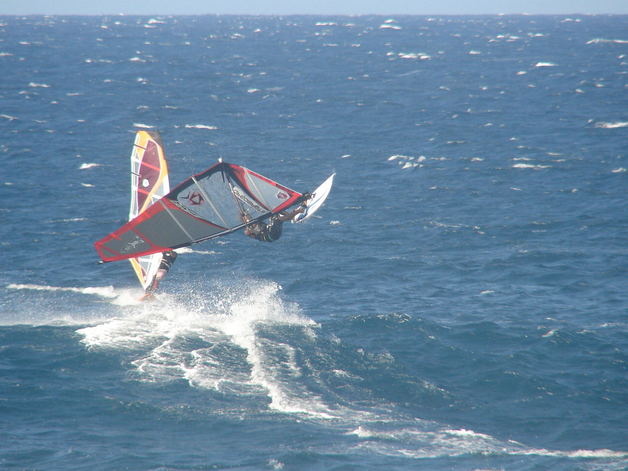
By the way, I'll explain this photo at the end of the post. In the meantime, try not to drool on your keyboard if you can.


Friday afternoon the windsurfing conditions at Hookipa were just beautiful, but something like 40 between international and local sailors were out... too many for my taste, so I sailed somewhere else. But Francky was in the water and took the usual bunch of great shots: amateur and pro galleries.

They're all gorgeous, but in particular I really like this one of Camille (unusual perspective from which you can see the eastern point of the bay and the surfers at Pavillions) and this one of Peter Volwater (looks like two mountains, one of which made of water).
That day I watched for 15 minutes and it was such an amazing show. Windsurfing at its best with most of the best sailors in the world. I feel like mentioning Mark Angulo going for a clew first forward off the lip, which I've never seen before.

I was sitting with two Cabo Verde experts (Kai Katchadourian and Francisco Porcella) and I asked them:"hey, why are all these people here if there's a contest in Cabo Verde in November? Why are they not training there?"
"'Cause over there you may easily break everything if you fuck up!"
I asked the same question to Josh Angulo (who I met in the shop).
"Josh, are all these sailors here because of that?"
"Nah, there's spots that are more mellow"
"So why are they here?"
"Don't know, the conditions are very different indeed"
"Well, why are you here then?"
"I got some business to do..."

My feeling is that even though Cabo Verde may offer epic, super clean, side off conditions once in a while, if you have 3-4 weeks and want to train in wave sailing, Maui is the place to be, in terms of consistency of wind and waves.

Anyway, let's move on to Saturday (yesterday).
The swell went down a lot and the wind started to blow strong and gusty from an easterly direction (which in Maui is a bit offshore).
It looked horrible to my very spoiled eyes and I happily decided to go for a photoshoot instead.
I don't have a favorite, so here are the pics in chronological order.

Luke.


Boujmaa.


Boujmaa jibing the sail mid backloop.


Luke.


Boujmaa.


Luke. Always picture perfect aerials.


When Francky left the water most of the pros left too. That's why next photos are mostly "normal" people, which is something I like a lot.
Don't know the name of this guy.


Aurelien shows us the graphic of the bottom of his custom board.


Argentinian Pablo in the landing phase of a push loop (I think).


Mr. Ordonez went for a sail.


Spanish sailor and nice guy (hey, I can't remember all the names...).


Italian freestyler Nicola Spadea is working on his wave sailing skills. Doing allright, I'd say!


Somewhere in there there's another italian guy who has been training pretty hard.


At one point I decided to call it a day, but while I stopped chatting with a friend on my way to my car, I saw my buddy Nino getting in the water. He arrived two days ago, and seen the relatively small waves, decided to sail Hookipa for his very first time.
I was so excited for him that, after taking this shot, I had to rig and go sail with him. By then (5pm) the wind had dropped enough for me to even enjoy the session (caught a couple of nice ones), but my joy was more the one reflected by the stoke of Nino. Good job!


Unfortunately, the forecast looks shitty (to my spoiled eyes).
Despite the fact that a new moderate swell will hit today in fact, a strong high pressure is about to take over the north pacific and generate strong, gusty, low quality, easterly winds.
This map is modeled to happen on Oct 27 and you can see how the high pressure is relegating that big storm north of the Aleutians... which is NOT where it belongs!


Fortunately, as this other map modeled for Nov 1st shows, ultimately that storm will manage to move south and offer a decent fetch that will generate a NW swell, but we're talking 10 days from now.


Last, but not least, I'd like to welcome a new blog sponsor: the young lady in the first shot is a model for Maui Girl bikinis and you'll find plenty more of her on their website. They bought a few months of a text link (can't think of a better blog sponsor), make sure you'll visit them!

I noticed that after the break with no posts (no internet connection for most of my trip), the number of unique readers has immediately gone back to almost a thousand a day (thanks everyone!), so if you're looking for a cheap and effective internet advertising, here are my prices:
Current prices for a banner: $50/month, or $45/month if you order 3 to 5 months upfront, or $40/month if you order 6 months or more upfront.
Current prices for a one line text link: $25/month or $20/month if you order 6 months or more upfront.