Saturday, March 31, 2018

6.10am nw swell is filling in at Hookipa. This set was head and a half. Clean.
8

Saturday 3 31 18 morning call

A longboard session for me yesterday. No photo of the day, here's an image by Ben Thouard.


4am significant buoy readings
South shore
No indication of southerly energy at the outer buoys, the Surfline forecast calls for 1f 10s. This south swell has lasted a whole week, but it's definitely coming down. Yesterday there were still waist high waves on the Lahaina side.

North shore
NW101
7.2ft @ 14s

Hanalei
8.1ft @ 14s from 304° (WNW)

Pauwela
3.8ft @ 9s from 70° (ENE)
1.9ft @ 16s from 321° (NW)

Pat Caldwell informed us that the NOAA NW Hawaii buoy 51101 went adrift though it is still near the original location. I'm gonna add that it doesn't show the swell direction anymore, at least on the Surfline page.
Below are the graphs of the three reported buoys. The new WNW swell has already peaked at Hanalei, while in Maui it will have a sharp rise in the morning. Seen the direction at Hanalei, the impact will be much higher at Hookipa than in Kahului. Surfline calls for 6f 14s from 308 in the afternoon.
The E swell is now down to 3.8f 9s after providing us with some fun size waves for the whole week.


Wind map at noon.

The one at 3pm shows potential for wind sports at Hookipa.


North Pacifc still shows a small NW fetch in the same place as the last two days.


South Pacific shows a small S and a small SSE fetch.


Morning sky.

Friday, March 30, 2018

Friday 3 30 18 morning call

A longboard and a SUP foiling session for me yesterday. Here's Jason Hall enjoying a foiling cut back on the small waves of the south side.


3am significant buoy readings
South shore

No indication of southerly energy at the buoys, the Surfline forecast calls for 1.3f 11s from 178 + 0.7f 14s from 212. Yesterday it was still up to belly high, I doubt it's completely gone today.

North shore
Pauwela
5.3ft @ 10s from 80° (E)

East swell went back up to 10s, Hookipa should be fairly small with a 80 degrees direction, bigger on the east exposed shores. The NW swell will show in Maui only tomorrow, as you can see from the Surfline forecast below (green line).

Wind map at noon. Once again, calm winds in the early morning everywhere.


North Pacific only shows the NW fetch still in place but getting weaker.


South Pacific doesn't offer anything of relevance.
.

Morning sky.

Thursday, March 29, 2018

7.10am east swell went down quite a bit while the south one still is thigh to belly high with occasional bigger sets and clean everywhere.

Thursday 3 29 18 morning call

Longboard and SUP foiling session for me yesterday in a day that saw excellent conditions both south and east thanks to the lack of wind. More of the same today.

This is an ass high wave in the afternoon at Thousand Peaks, but there were up to chest and occasionally even head high ones.


We received a bunch of Gofoil foils at Hi-Tech, all kind of singles and combos.


3-4am significant buoy readings
South shore
W
3.1ft @ 12s from 137° (SE)

SW
3.1ft @ 12s from 177° (S)

Period going down at the outer buoys, but size still pretty solid. Waves on the south shore also today.

North shore
Pauwela
5.5ft @ 9s from 77° (ENE)

East swell down one second too, but also today there will be waves on the east facing shores and pristine conditions in the early morning.

Wind map at noon shows light onshores on the north shore, but once again the morning should be calm.

Here in fact is the map at 7am. I had to post it as I'm becoming a huge fan of the color purple. It means glassy. This model is the link n.-2 of the GP's meteo website list. You click on the animation of the second column and get the evolution hour by hour.


North Pacific shows the the NW fetch getting smaller (but the weekend NW swell is on its way) and unfortunately no more east fetch.


South Pacific shows a small fetch.


Morning sky. Looks like another glorious day.

Wednesday, March 28, 2018

Wednesday 3 28 18 morning calls

Longboard session for me yesterday. Below are two Jimmie Hepp's photos from yesterday to show that there's waves at Thousand Peaks and in Waiehu. Which is something that if you read the buoys, you should know already.


4am significant buoy readings
South shore
W
2.9ft @ 14s from 157° (SSE)

SW
3.4ft @ 13s from 166° (SSE)

SE
3.8ft @ 13s from 152° (SSE)

Pretty solid numbers at the outer buoys. Since the waves have been good to excellent on the north shore, I haven't gone south, but I might have to check it out today.

North shore
5.7ft @ 9s from 75° (ENE)

Lovely pure windswell reading at Pauwela, that'll still make waves at Hookipa, but the east facing breaks  will get the most exposure.

Wind map at noon shows a light onshore flow, but there should be no wind at all for most of the morning.


The clean surfing conditions are predicted to continue, as the Windguru table below shows light winds from all kind of favorable directions.


North Pacific shows the weekend NW swell fetch getting closer to us and building the same waves it generated yesterday (captured fetch) and the relentless E fetch.


Nothing at all in the South Pacific.


Morning sky.

Tuesday, March 27, 2018

6.10am Hookipa is smaller than yesterday, but still head high plus.
6

Tuesday 3 27 18 morning call

Triple shortboard session for me yesterday. When the waves are good I surf, because the only thing I'm loyal to is the fun. Here's a few shots of the day.

Little grom overhead drop at the harbor.


Less little grom, but still grom and still well overhead at The Point at Sunset.


Browsinho at Lanes.


Uncle drop at Pavils.


The Point had some moments of awesomeness in the morning and at sunset.


Little cover up at Pavils.


Blog author on session n.3.


4am significant buoy readings
South shore

W
1.7ft @ 17s from 162° (SSE)

SW
2.7ft @ 15s from 177° (S)

SE
3.8ft @ 14s from 138° (SE)

Pretty solid southerly energy at the outer buoys, below is the collage of the maps of March 19, 20 and 21 to show you that there were two sources: one deep in the Tasman Sea and a low SSE of Tahiti.
There should hence be waves on the south shore, but the Kona wind will still blow them out today.

North shore
Pauwela
7.2ft @ 10s from 57° (ENE)

It's very refreshing to read only one swell at Pauwela, as it rarely happens. The number is quite higher than the Surfline forecast and even though the direction is more east than yesterday, Hookipa will still have waves this morning.

Wind map at noon. Still Konas.


North Pacific shows for the first time the NW fetch that will send us the weekend swell (7f 14s Saturday evening) and the E fetch.


South Pacific doesn't offer much, as the fetch in the map on the right will be completely blocked by New Zealand.


Morning sky.

Monday, March 26, 2018

6.50am Hookipa is head to head and a half and clean with light konas.
8

Morning 3 26 18 morning call

Douuble SUP session for me yesterday, here's some photos from the first one.


Hi-Tech store manager Steve Roan.


Another one for Steve, got to keep the manager happy.


And since we're in foiling mode, here's a video posted by Flash Austin with his... thing.


This photo was taken by blog reader Tyrell at 6pm on the 24th and it shows that some of the big Fiji swell did make it to Maui's south shores. Surfline made this feature to document a spectacular week of waves down there.


5am significant buoy readings
South shore

Most buoys on the Surfline page are down, the Surfline forecast calls for 1.8f 12s.

North shore
Pauwela
6ft @ 10s from 42° (NE)
4.9ft @ 12s from 11° (NNE)

Still solid energy from the NNE and the NE. Stay tuned for a Hookipa beach report before 7am.

Wind map at noon shows some Konas in the Kahului area. Yesterday this model was totally off, the Kona at 2pm didn't happen. We can call it a model glitch. I apologize, I should have checked that the three models on Windguru didn't have it and question it, but I was in a hurry and didn't. Today though, they all show the southerly flow and the wind in Kahului is already blowing S at 6am.


North Pacific only shows an E windswell fetch and that's what we're gonna have for most of the week, before a solid NW swell will hit on Saturday.


South Pacific shows a new small Tasman Sea fetch.


Morning sky.

Sunday, March 25, 2018

Sunday 3 25 18 morning call

Two SUP foiling session for me yesterday in conditions that Dave Kalama define as "so carvable!". And that's what he's doing in this photo taken by blog reader Justin (thanks!). He shaped himself a 4.11 SUP foiling board and that looks like it might be it. Notice the shift of weight towards the front foot in order to keep the foil down as it will accelerate in the cutback he's about to initiate and would come out of the water otherwise. You can learn so much just watching him and I've been doing a lot of that. As a result, something has clicked and I'm now starting to do some decent carving myself and it's a lot of fun. That's why I went twice yesterday, despite the fact that the waves were good all day everywhere on the north shore.


That's how the waves looked at Hookipa at sunset, in fact.


A quick zoom in allowed me to catch the guy who went left on that wave.


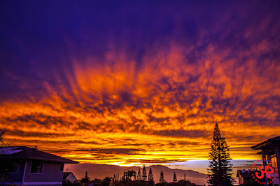
Later on, the sunset went off in spectacular fashion. Photo by Jimmie Hepp.


5am significant buoy readings
South shore

W
3ft @ 13s from 170° (S)

SE
3.4ft @ 13s from 173° (S)

Solid southerly energy readings at the outer buoys, while the Surfline forecast calls for 2f 14s. I have no reports from the south shore, so I don't know what that translates to locally (nobody can predict the blockage from Kahoolawe). But there's a southerly wind flow, so conditions might not be the cleanest.

North shore
Pauwela
5ft @ 8s from 68° (ENE)
4.1ft @ 13s from 12° (NNE)
 
The very long lasting swell that has delighted us all week is coming down in size and period and going more east, but exposed breaks will still receive plenty waves out of those 5f 8s. What's new is those 4f 13s from 12, which Pat Caldwell and the NOAA don't even mention. As you can see below, Surfline instead had them in the forecast (blue line on the right part of the collage, the left part being the Pauwela graph).
The Surfline forecast is incredibly accurate, as long as you only check the "offshore swell heights" tab. Don't waste your time checking the spot forecasts, they are useless. See what's predicted to be out in the ocean and make your own guess for the spot of your interest.


I didn't remember seeing a fetch that would justify this new swell, so I retrieved the map of March 22 and noticed I completely overlooked a fetch in the gulf of Alaska corner. I now circled it in black.


Wind map at noon shows light winds on the north shore...
 
...but wind map at 2pm shows a burst of Konas squeezing through the valley. If it happens, it might be sailable in the late afternoon.


North Pacific shows a weak NW fetch and an E windswell one.


South Pacific shows a SSE fetch (third day in a row, I think).


Morning sky. I might be the only one on the island hoping that those clouds don't move away. A cloudy sky makes for less wind.