
Wednesday, November 30, 2016
11 30 16 morning call
Couple of sessions for me yesterday, one of which was with the foil, so I'm gonna talk about it in detail. So skip to the buoy readings if you don't care about foiling and just want to read the call.
So far my only experience with a foil was with on an SUP board being towed behind a boat. I only tried like 4-5 pulls and didn't have much success at all.
Yesterday I had the same board/foil, but I tried to catch small waves on the south shore. Let me tell you straight one thing: it was still difficult, but a lot easier than behind the boat.
Here's what you need to know to understand that. Other than one water skiing session when I was 15, my experience at being towed by a boat was none. So, being towed felt like a strange feeling all the times, even before the foil came up. Plus there was the awkwardness of having to hang on a rope that is pulling you forward, the noise of the engines, the weird bubbles left by them, a bunch of friends on the boat looking at you and overall I didn't have much fun at all, to be honest with you.
Instead while catching a gentle roller on the south shore, until the foil came up I was in extremely familiar territory. I was all ready in perfect stance and confident that I knew how to do that. No noise, no fumes, no weird bubbles, no distractions, all by myself. And even though I was going way slower than behind the boat, I was so in control that I could decide to push on the back foot to let the foil come up. And after that I managed to shift my weight on the front foot to bring it back down.
I only caught 4-5 waves and obviously I did wipe out without control on most of them, but I managed to stay away from the foil. The possibility of an impact with it is there though. Fortunately the wave SUP GoFoil (Alex Aguera design, made by Go Foil for Starboard) is pretty blunt, it might not cut you, but it'll still hurt you. Even the wipeouts seemed a less dangerous than the ones I experienced behind the boat though, thanks to the slower speed at which they happened.
A key factor in the learning process is to choose the right spot. Obviously you need enough water for the foil, so avoid shallow spots and low tides. The spot I was out seemed deep enough with something like a foot of tide, but I still managed to brush the bottom while paddling out.
After I hit the bottom and put some scratches on the foil, I paddled back in and waited for a higher tide. Which obviously came a couple of hours later, but it completely killed the small waves.
The thing is that you need some waves too and yesterday there were some, but they were tiny. Which means that they were breaking very close to shore. Ideally you want to have a couple of feet of swells in the water, high tide, no wind and all those waves on the lahaina side of Thousand peaks can become a perfect spot where to practice. I know, that doesn't happen very often because of the wind, that's when you can pick a spot between Launiupoko and Puamana. I can see the Cove in Kihei as a good spot too at high tide, but please make sure you pick a spot with nobody else around (good luck!).
The waves need to be big enough that you can catch it with your SUP. The foil doesn't come into play until you catch the wave, because only after you're going fast enough that you can make it come up. And, once again, that is what made yesterday's experience relatively easy and not as stranger. Until you have the two rails of the board touching the water, even if the foil is lifting most of the board and it's just the tail touching the water, you are still in familiar territory. As soon as those rails don't touch the water anymore, it's like someone suddenly took from you the crutches that you didn't even know you had! And that's when the new sport starts, I'd say.
That's when it becomes extremely critical to keep your weight centered on the center line. If you shift it either tow or heel side, you're going down for sure, because the thing reacts much quicker than a regular board. Of course, you got no crutches anymore! On your first waves, you want to focus on going straight and keeping the foil leveled. Learn how to make it go up and down by shifting the weight back and front. Which is what Kai does when he pumps the thing. I was able to do a little bit of that yesterday and that's why I consider it a successful session. Much better than behind the boat, at least.
Did I learn how to foil? Of course not, but I made significant progress. Once again, I only had 4-5 waves and than the conditions disappeared. Finding the right conditions, might easily be the factor that slows down your learning, that's the feeling I have.
Here's two applications of the foil that attract me:
1) surfing low quality small mushy waves (pretty much like every summer afternoon in Lahaina as soon as the onshore flow starts)
2) downwinders
I don't see myself doing this on a good wave, in other words I don't see this activity in possible competition with regular surfing. Check the video below for example.
It starts with Kai riding a perfect foil wave on the inside of Namotu. Then it switches a beautiful fun size wave at Cloudbreak, Kai surfs it lamely compared to what he could have done on a high performance shortboard, kicks out of it way too early because he wanted to go around Jace who is filming in the water, pumps his wave towards the wave out the back, grabs that one and surfs it lamely again.
It looks cool at first, but in my opinion that was a shameful waste of a beautiful wave. Two, actually.
Then it goes back to what I think it's the perfect wave for foiling. A wave that isn't even breaking or is low quality enough that you would not be surfing it otherwise.
And here's another video of a downwinder by Kai. Doesn't matter (I think) if you start prone or with the paddle on a SUP board, as long as you can get the foil up and keep it there and do what he does, I think it should be fun. To keep it flying with small windswell waves, you need some wind off your back, that's for sure. And if the wind dies, it will be easier to continue your slow downwind paddle on a SUP than on a 5.6 shortboard, that's for sure too.
I also don't think you want to learn how to foil on a downwind run right away. I see it much easier to learn on small south shore waves first (and Alex Aguera agrees with that) and THEN putting your skills out there in the middle of the ocean and trying a downwinder.
Problem is that the foil for a downwinder appears to be different than a foil for waves (wider for more lift at slow speed and less maneuverable), so you might have to get two foils for each of those two applications I just mentioned. It's too early in the sport for these details. At the moment we only have the wave SUP foil at Hi-Tech, but soon we'll receive the downwind ones (I'll let you guys know here for sure).
I might have to start by buying a wave foil (not sure my boss will lend me his anymore after the small scratches I put!). They are expensive (I think they retail for $1650 or something like that). But just like at the very beginning of SUP boards back in 2004/2005, it doesn't matter what you bought, the demand was so high that you could always resell your board at any time.
The sport is not going to be as big as SUP surfing. Not a chance. But there will still be enough demand and very limited offerings, at least for a while. So get yourself a foil before we run out of them. Your biggest problem will be to decide what board to convert with the installation of the tuttle box...
5am significant buoy readings
South shore
Lanai
Small southerly energy at the Lanai buoy (and none at Barbers), with a lovely half foot 18s that Pat Caldwell totally called for in his table. Check the webcam and see if you like it!
North shore
Pauwela

So far my only experience with a foil was with on an SUP board being towed behind a boat. I only tried like 4-5 pulls and didn't have much success at all.
Yesterday I had the same board/foil, but I tried to catch small waves on the south shore. Let me tell you straight one thing: it was still difficult, but a lot easier than behind the boat.
Here's what you need to know to understand that. Other than one water skiing session when I was 15, my experience at being towed by a boat was none. So, being towed felt like a strange feeling all the times, even before the foil came up. Plus there was the awkwardness of having to hang on a rope that is pulling you forward, the noise of the engines, the weird bubbles left by them, a bunch of friends on the boat looking at you and overall I didn't have much fun at all, to be honest with you.
Instead while catching a gentle roller on the south shore, until the foil came up I was in extremely familiar territory. I was all ready in perfect stance and confident that I knew how to do that. No noise, no fumes, no weird bubbles, no distractions, all by myself. And even though I was going way slower than behind the boat, I was so in control that I could decide to push on the back foot to let the foil come up. And after that I managed to shift my weight on the front foot to bring it back down.
I only caught 4-5 waves and obviously I did wipe out without control on most of them, but I managed to stay away from the foil. The possibility of an impact with it is there though. Fortunately the wave SUP GoFoil (Alex Aguera design, made by Go Foil for Starboard) is pretty blunt, it might not cut you, but it'll still hurt you. Even the wipeouts seemed a less dangerous than the ones I experienced behind the boat though, thanks to the slower speed at which they happened.
A key factor in the learning process is to choose the right spot. Obviously you need enough water for the foil, so avoid shallow spots and low tides. The spot I was out seemed deep enough with something like a foot of tide, but I still managed to brush the bottom while paddling out.
After I hit the bottom and put some scratches on the foil, I paddled back in and waited for a higher tide. Which obviously came a couple of hours later, but it completely killed the small waves.
The thing is that you need some waves too and yesterday there were some, but they were tiny. Which means that they were breaking very close to shore. Ideally you want to have a couple of feet of swells in the water, high tide, no wind and all those waves on the lahaina side of Thousand peaks can become a perfect spot where to practice. I know, that doesn't happen very often because of the wind, that's when you can pick a spot between Launiupoko and Puamana. I can see the Cove in Kihei as a good spot too at high tide, but please make sure you pick a spot with nobody else around (good luck!).
The waves need to be big enough that you can catch it with your SUP. The foil doesn't come into play until you catch the wave, because only after you're going fast enough that you can make it come up. And, once again, that is what made yesterday's experience relatively easy and not as stranger. Until you have the two rails of the board touching the water, even if the foil is lifting most of the board and it's just the tail touching the water, you are still in familiar territory. As soon as those rails don't touch the water anymore, it's like someone suddenly took from you the crutches that you didn't even know you had! And that's when the new sport starts, I'd say.
That's when it becomes extremely critical to keep your weight centered on the center line. If you shift it either tow or heel side, you're going down for sure, because the thing reacts much quicker than a regular board. Of course, you got no crutches anymore! On your first waves, you want to focus on going straight and keeping the foil leveled. Learn how to make it go up and down by shifting the weight back and front. Which is what Kai does when he pumps the thing. I was able to do a little bit of that yesterday and that's why I consider it a successful session. Much better than behind the boat, at least.
Did I learn how to foil? Of course not, but I made significant progress. Once again, I only had 4-5 waves and than the conditions disappeared. Finding the right conditions, might easily be the factor that slows down your learning, that's the feeling I have.
Here's two applications of the foil that attract me:
1) surfing low quality small mushy waves (pretty much like every summer afternoon in Lahaina as soon as the onshore flow starts)
2) downwinders
I don't see myself doing this on a good wave, in other words I don't see this activity in possible competition with regular surfing. Check the video below for example.
It starts with Kai riding a perfect foil wave on the inside of Namotu. Then it switches a beautiful fun size wave at Cloudbreak, Kai surfs it lamely compared to what he could have done on a high performance shortboard, kicks out of it way too early because he wanted to go around Jace who is filming in the water, pumps his wave towards the wave out the back, grabs that one and surfs it lamely again.
It looks cool at first, but in my opinion that was a shameful waste of a beautiful wave. Two, actually.
Then it goes back to what I think it's the perfect wave for foiling. A wave that isn't even breaking or is low quality enough that you would not be surfing it otherwise.
And here's another video of a downwinder by Kai. Doesn't matter (I think) if you start prone or with the paddle on a SUP board, as long as you can get the foil up and keep it there and do what he does, I think it should be fun. To keep it flying with small windswell waves, you need some wind off your back, that's for sure. And if the wind dies, it will be easier to continue your slow downwind paddle on a SUP than on a 5.6 shortboard, that's for sure too.
I also don't think you want to learn how to foil on a downwind run right away. I see it much easier to learn on small south shore waves first (and Alex Aguera agrees with that) and THEN putting your skills out there in the middle of the ocean and trying a downwinder.
Problem is that the foil for a downwinder appears to be different than a foil for waves (wider for more lift at slow speed and less maneuverable), so you might have to get two foils for each of those two applications I just mentioned. It's too early in the sport for these details. At the moment we only have the wave SUP foil at Hi-Tech, but soon we'll receive the downwind ones (I'll let you guys know here for sure).
I might have to start by buying a wave foil (not sure my boss will lend me his anymore after the small scratches I put!). They are expensive (I think they retail for $1650 or something like that). But just like at the very beginning of SUP boards back in 2004/2005, it doesn't matter what you bought, the demand was so high that you could always resell your board at any time.
The sport is not going to be as big as SUP surfing. Not a chance. But there will still be enough demand and very limited offerings, at least for a while. So get yourself a foil before we run out of them. Your biggest problem will be to decide what board to convert with the installation of the tuttle box...
5am significant buoy readings
South shore
Lanai
1.4ft @ 13s from 229° (SW)
1.2ft @ 3s from 3° (N)
1.1ft @ 7s from 159° (SSE)
0.5ft @ 18s from 215° (SW)
Small southerly energy at the Lanai buoy (and none at Barbers), with a lovely half foot 18s that Pat Caldwell totally called for in his table. Check the webcam and see if you like it!
North shore
Pauwela
6.2ft @ 10s from 85° (E)
5.1ft @ 8s from 76° (ENE)
3.4ft @ 13s from 338° (NNW)
No NW energy on any other buoys tell me that whatever is leftover in the water is not going to be particularly significant. So it's going to be mostly windswell with the occasional NW set and it could be one of smallest/roughest day we've see in a while.
Current wind map shows a wide NW fetch (latest Surfline forecast calls for 7f 16s Friday afternoon), the windswell one and a weak one down under.

MC2km map at noon shows the usual lot of wind. Again, it might end up being even stronger if the sun shines or much weaker if it's rainy all day (like yesterday).

Tuesday, November 29, 2016

11 29 16 morning call
Yesterday I surfed Lahaina in the morning (waves were tiny, but clean and I didn't even wear a wetsuit to enjoy the lack of wind and the sunshine on my skin) and sailed Hookipa in the afternoon.
This pic by Jimmie Hepp from this gallery shows the strong and gusty conditions. It got a lot lighter later on (that's why I went out), but it was still gusty.
I took some pics myself after my session and I was glad to catch Glen's last wave of his stay. Till next time!

There were some seriously good surfers out there. This is Imai De Vault.

But I missed to get an action shot of Felipe Toledo! Well, shaking the car to make the little surfer hanging by the rear view mirror do crazy aerials is still some kind of action...
10 for the seat covers, btw.

I couldn't pass the opportunity to ask a few questions to the fastest surfer on the planet. Here's the little interview.
And this is our friend Tijolo showing one of the boards of the old school session.
5am significant buoy readings
South shore
Lanai
1.9ft @ 14s from 221° (SW)
Barbers
Current wind map shows the strong but distant NW fetch that is making the Friday/Saturday swell. It's not in a good position for Honolua and that won't change in the next few days. This year, they weren't lucky. There's also a small windswell fetch and a weak one down under.

NAM3km map at noon shows moderate trades that might easily become strong if sunny. It's actually always more than what it shows for Hookipa (17 knots today and around 20 the past few days).

I'm soon gonna do a richer post about the new exciting evolution of downwind runs on foils. In the meantime, check out this video that Kai Lenny put out yesterday.
I don't know about you, but I watch it and think to myself:"I wonna do that!".
It's been almost 13 years since I learned a new sport (last one was SUP surfing back in early 2004) and I'm excited at the idea. Training starts this morning.
This pic by Jimmie Hepp from this gallery shows the strong and gusty conditions. It got a lot lighter later on (that's why I went out), but it was still gusty.

I took some pics myself after my session and I was glad to catch Glen's last wave of his stay. Till next time!

There were some seriously good surfers out there. This is Imai De Vault.

But I missed to get an action shot of Felipe Toledo! Well, shaking the car to make the little surfer hanging by the rear view mirror do crazy aerials is still some kind of action...
10 for the seat covers, btw.

I couldn't pass the opportunity to ask a few questions to the fastest surfer on the planet. Here's the little interview.
And this is our friend Tijolo showing one of the boards of the old school session.

5am significant buoy readings
South shore
Lanai
1.9ft @ 14s from 221° (SW)
Barbers
2.9ft @ 14s from 202° (SSW)
SSW swell went down to 14 seconds but up to almost 3 feet at Barbers. Check the webcam for indication of size, consistency and wind.
North shore
NW
5.8ft @ 12s from 318° (NW)
Hanalei
4.6ft @ 13s from 318° (NW)
Pauwela
5.6ft @ 11s from 88° (E)
NW
5.8ft @ 12s from 318° (NW)
Hanalei
4.6ft @ 13s from 318° (NW)
Pauwela
5.6ft @ 11s from 88° (E)
4.6ft @ 6s from 69° (ENE)
4.6ft @ 9s from 78° (ENE)
2.5ft @ 15s from 341° (NNW)
Wow, the NW swell is reading almost 6f at the NW buoy and almost 5 at the Hanalei one, but only 2.5f at the Pauwela one (and from a completely different direction). Why is that? I have no idea!
It is what it is and I would recommend to check the buoy page again later to see if that was just a glitch. FYI, At 4am there was actually no NW energy reported at Pauwela.
Windswell starting to come down in size and becoming more east (should be a lot less of it at Hookipa).
Anyway, whatever is in the water from the NW, should stay pretty steady throughout today.
Current wind map shows the strong but distant NW fetch that is making the Friday/Saturday swell. It's not in a good position for Honolua and that won't change in the next few days. This year, they weren't lucky. There's also a small windswell fetch and a weak one down under.

NAM3km map at noon shows moderate trades that might easily become strong if sunny. It's actually always more than what it shows for Hookipa (17 knots today and around 20 the past few days).

I'm soon gonna do a richer post about the new exciting evolution of downwind runs on foils. In the meantime, check out this video that Kai Lenny put out yesterday.
I don't know about you, but I watch it and think to myself:"I wonna do that!".
It's been almost 13 years since I learned a new sport (last one was SUP surfing back in early 2004) and I'm excited at the idea. Training starts this morning.
Monday, November 28, 2016
11 28 16 morning call
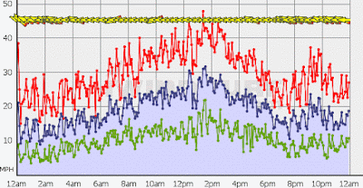
Nothing that I saw on the north shore yesterday inspired me to get in the water, so I took a rare day off. But I went as close as taking the windsurf gear out of the car at Hookipa in the late afternoon (I even put the mast foot on the board!), but I couldn't force myself to go out in conditions that were far from what I like. And looking at the iWindsurf.com Hookipa wind graph, I am not regretting that decision a bit. Even at 5pm there were gusts up to 35mph.
Someone who doesn't have any problem with strong/gusty wind appears to be Graham Ezzy, here pictured in this photo by Jimmie Hepp taken from this gallery.
I need an alternative for these super windy days, for there will be plenty also this week and, being a la Nina winter, plenty more also this winter. The alternative is there, I can see it pretty clearly, but it requires skills and gear that I don't have yet. I'll talk about it more in the near future.
3am significant buoy readings
South shore
Lanai
1.5ft @ 15s from 219° (SW)
Barbers
2.1ft @ 15s from 196° (SSW)
A small south swell is here. Yesterday the lahaina webcam looked good all morning and I should have dawn patrolled it before work, but it's hard to pull that off with the sunrise happening an hour later than in summer time. The only way is to leave in the dark, like at 5.30, but without checking the webcam there's the risk of getting there and finding an onshore flow created by the strong trades. It has been the case pretty much every day last week. It wasn't the case yesterday. And there no model that can predict that, it's too much of a localized thing.
North shore
NW
3.5ft @ 13s from 348° (NNW)
Hanalei
2.2ft @ 15s from 320° (NW)
Pauwela
10.3ft @ 9s from 79° (ENE)


 Current wind map shows a strong WNW fetch just coming off the Kamchatka corner. That's the fetch that is supposed to send the big swell over Friday/Saturday. The evolution of it didn't particularly impress me on the windity run I just did, and in fact the new Surfline prediction is now reduced to 8.6f 15s from 317 on Friday. Great swell for big Sunset Beach, but most definitely not the best direction for Honolua.
On the map there's also a weak NNW fetch, the windswell fetch (turning more easterly) and a partially blocked fetch just south of New Zealand that I forgot to circle.

NAM3km map at noon shows strong easterly trades.


Someone who doesn't have any problem with strong/gusty wind appears to be Graham Ezzy, here pictured in this photo by Jimmie Hepp taken from this gallery.

I need an alternative for these super windy days, for there will be plenty also this week and, being a la Nina winter, plenty more also this winter. The alternative is there, I can see it pretty clearly, but it requires skills and gear that I don't have yet. I'll talk about it more in the near future.
3am significant buoy readings
South shore
Lanai
1.5ft @ 15s from 219° (SW)
Barbers
2.1ft @ 15s from 196° (SSW)
A small south swell is here. Yesterday the lahaina webcam looked good all morning and I should have dawn patrolled it before work, but it's hard to pull that off with the sunrise happening an hour later than in summer time. The only way is to leave in the dark, like at 5.30, but without checking the webcam there's the risk of getting there and finding an onshore flow created by the strong trades. It has been the case pretty much every day last week. It wasn't the case yesterday. And there no model that can predict that, it's too much of a localized thing.
North shore
NW
3.5ft @ 13s from 348° (NNW)
Hanalei
2.2ft @ 15s from 320° (NW)
Pauwela
10.3ft @ 9s from 79° (ENE)
1.7ft @ 16s from 351° (N)
Windswell still pumping locally, while the graph of the NW buoy below shows the slow rise of the new small NW swell, which might get up to 3f 14s late this afternoon locally. The direction is all over the place at the three buoys I reported above, but the buoys can be quite not precise with that, specially at the beginning of a swell.

Looking at the wind map of Nov 24 below will help us understand where that swell is really coming from.
You can see a strong but small fetch all the way up in the NW corner and that's the one.


On Nov 25 it moved south, so the swell should actually turn more west for us on its second day.

4am significant buoy readings
North shore
NW
North shore
NW
3ft @ 13s from 286° (WNW)
Hanalei
2.6ft @ 15s from 340° (NNW)
Pauwela
Hanalei
2.6ft @ 15s from 340° (NNW)
Pauwela
8.7ft @ 9s from 78° (ENE)
1.7ft @ 16s from 344° (NNW)
Here we go, above are the 4am readings that in the meantime became available and the directions got all shuffled up. Look how west the swell is at the NW buoy now! Again, I saw this happening very often at the beginning of a swell, so I'm not too surprised.
And I thought that maybe it's whatever Surfline does to separate the energy of the different swells from the raw data provided by the buoy that can be wrong. So I went on the "old" NOAA NW buoy website to double check the direction there and... there's no even a sign of the new NW swell! So, even the Surfline buoy page does screw up the direction a bit at the beginning of a new swell, it still tells us much more information than the extremely poor and deceiving information provided by the table below by the NOAA.
Link n.8 is called the Bible for a reason. You just got to trust it.
Link n.8 is called the Bible for a reason. You just got to trust it.

On the map there's also a weak NNW fetch, the windswell fetch (turning more easterly) and a partially blocked fetch just south of New Zealand that I forgot to circle.

NAM3km map at noon shows strong easterly trades.

Sunday, November 27, 2016

11 27 16 morning call
Just a session for me yesterday. I don't have an action shot of the day, so here's a Tahitian wave from Ben Thouard's page.

5am significant buoy readings
South shore
Lanai
1.4ft @ 16s from 215° (SW)
Barbers
1.9ft @ 16s from 203° (SSW)
Lovely bit of 16s energy from the SSW at the buoys, below is the wind map of 7 days ago (Nov 20th), I think we're getting the energy coming from the very tail of the cock roach. The head of it is just aiming too much to the east and we are not getting the angular spreading I was hoping for. That would have had a much more S to SSE or even SE direction. But we have something, so check the webcam if you want to go Lahaina side!

North shore
Pauwela
10.1ft @ 8s from 76° (ENE)
NW energy is gone (or at least not recorded by the Pauwela buoy that must be tired to go up and down 10 feet every 8 seconds!), 76 degrees windswell is all that is on offer today.
Don't waste your time checking if they're gonna run Honolua and/or Sunset, the answer is no. The next (small) NW swell might get Sunset going tomorrow, but the only next chance for Honolua is that swell forecasted for Friday/Saturday, which is now downgraded to 9f 16s. The fetch hasn't formed yet we'll see how it looks when it happens around Tuesday.
Current wind map shows a not so strong NW fetch, the windswell fetch and a fetch down south (forgot to circle) heavily blocked by New Zealand. Notice how the high pressure moved a tad to the east

MC2km map at noon shows another strong and gusty easterly trades day.

It's the Sunday of one of the windiest weeks I can remember. Thank god it's over, but this coming week doesn't look much better. The Windguru table below (I'm officially missing the old two rows style) shows a little weakening back to normal levels on Monday, but then we have another strip of red intensities until Friday. If confirmed, no wind on Saturday for a few days (can't wait!), but that is actually not a good thing for Honolua.

Saturday, November 26, 2016

11 26 16 morning call
A surf and a windsurf session for me yesterday, it wasn't easy to find the conditions that I would enjoy, but I managed to for both. Sometimes, it's a waiting game.
I grabbed this photo from Kai Lenny's instagram page. He was in Fiji for whatever SUP contest and of course he didn't miss the opportunity of getting seriously shacked at Cloudbreak. Here's what he wrote: "This was my third trip to Fiji this year and I still don't feel like it was enough. You can never have to much barrel therapy! I do feel like I have come a long way surfing Cloudbreak. When I was a little kid it started off with a few tower tours and Fijian tattoos. Now my barrel to reef rash ratio has improved to the point I'm leaving this beautiful place with all my skin!"
I left this comment:"You're leaving? 10ft 15s on Wednesday brah!", but I'm sure he knows that already.

In the afternoon, I briefly stopped by Hookipa and took a few hand held shots sitting on the guardrail.
Below is Federico Morisio on a wave that was well over mast high and that I'm gonna use to explain something.
Let's try to guess the size of the highest point of the wave. The mast is 4 meters. Where to lip is breaking (a little downwind of him), for me it's around 6 meters, which is 20 feet. Maybe a little generous, but stick with me.
As we will see in the forecast vs buoy graphs comparison below, in the water there were two mains swells:
- 4f 18s from 325, which I'm gonna call ground swell
- 9f 9s from around 75 (which is parallel to the Kahului to Hookipa coast line), which I'm gonna call windswell
That wave he's on is clearly a long stretched wall of the ground swell. 4f 18s from an unblocked direction can easily produce mast high waves at Hookipa. But that extra half mast on the peak is just as clearly due to the windswell that is travelling across (right to left) and adds it's own energy and size. That peak would actually not be there at all, if there wasn't a windswell in the water at the same time.
That's the wave that made me decide not to sail there, btw. Mast and a half peaks, plenty chop and occasional channel closing sets, means too high chance to go on the rocks with my skills.

Gorgeous bottom turn by Levi Siver.

Really proud of this shot of this successful sick aerial by Antoine Martin. I was just standing when this happened.

5am significant buoy readings
South shore
Lanai
2ft @ 15s from 296° (WNW)
Barbers
1.5ft @ 18s from 198° (SSW)
The southerly energy disappeared at the Lanai buoy, probably overwhelmed by the wrap of the NW swell, but it's clearly still there. The new pulse coming from the day when the fetch moved east of New Zealand is actually reading a beautiful foot and a half with 18s period at Barbers. Worth a look at the Lahaina webcam, for sure.
North shore
NW
9.1ft @ 9s from 86° (E)
Pauwela
8.8ft @ 9s from 73° (ENE)


One more example, otherwise you guys won't believe me. This is the Magiseaweed forecast for Hookipa for today. I like that they have two colums for the primary and secondary swell (I don't like that it's a table instead of a graph though). I like that they call the ground swell primary and the windswell secondary (like it should be).
But what the hell is the Surf column saying? Is it going to be 3-4f at noon? Faces? I should send them that photo from yesterday and tell them "hey, you guys were only 15 feet off..."
Anyway, stick to the offshore swells predictions and make your own guess of the actual size is my recommendation.
As far as I know, only Pat Caldwell tries to put his local knowledge in his table. Everybody else just grabs the publicly available WW3 model output (which uncle Pat checks too, of course) and put it in different graphic forms.
Surfline is my favorite graphic form and, (I'm finally going to conclude this long dissertation), from that graph you now know that the ground swell will be declining all day, while the windswell will stay steady.
If they didn't run Honolua and Sunset yesterday, I doubt they will do it today. The possibility of the ladies moving the whole production to Pavillions is real. And that is exciting for me, 'cause in that case I'm gonna be taking photos from the rocks. Work permitting, of course.

-- 9am update after having watched the morning show: they're also going to monitor that big NW swell forecasted for the last two days of the waiting period: Friday Dec 2nd and Saturday 3rd. The swell is predicted to be 10.7f 15s from 317 on Surfline at 8am on Saturday (no need to specify which tab I'm looking at at this point) and even though that is blocked direction for the Bay, it's big enough for the more northerly sets to wrap in there. The problem is that is based on a fetch that hasn't formed yet. It's in the output of the wind models (the GFS being the most commonly used) and that can change. We'll see. --
Current wind maps shows:
- a weak and distant NW fetch (the much stronger one to the NE of it is so west to east that I didn't feel like circling)
- the windswell fetch
- another day of strong Tasman Sea fetch. Too bad Kai is leaving Fiji...

Today it's a little later than usual, so my favorite wind prediction website has its maps updated and here is the MC2km map at noon showing the usual strong easterly trades. Maybe a tad more offshore than it has been?
Well, since I had prepared it already, this is also the NAM3km map at noon and it confirms the offshore nature of today's trades. Even gustier at Hookipa. I actually like the graphical representation of this one a bit better, but its resolution is not as precise as the one above. The wind in the Thousand Peaks area is a good example of that.

PS. I think this is one of the best posts I've done about how to read the wave forecasts, and I'm going to label it just that ("how to read the wave forecasts") to make it easily accessible through the "labels" section of this blog for future references.
I grabbed this photo from Kai Lenny's instagram page. He was in Fiji for whatever SUP contest and of course he didn't miss the opportunity of getting seriously shacked at Cloudbreak. Here's what he wrote: "This was my third trip to Fiji this year and I still don't feel like it was enough. You can never have to much barrel therapy! I do feel like I have come a long way surfing Cloudbreak. When I was a little kid it started off with a few tower tours and Fijian tattoos. Now my barrel to reef rash ratio has improved to the point I'm leaving this beautiful place with all my skin!"
I left this comment:"You're leaving? 10ft 15s on Wednesday brah!", but I'm sure he knows that already.

In the afternoon, I briefly stopped by Hookipa and took a few hand held shots sitting on the guardrail.
Below is Federico Morisio on a wave that was well over mast high and that I'm gonna use to explain something.
Let's try to guess the size of the highest point of the wave. The mast is 4 meters. Where to lip is breaking (a little downwind of him), for me it's around 6 meters, which is 20 feet. Maybe a little generous, but stick with me.
As we will see in the forecast vs buoy graphs comparison below, in the water there were two mains swells:
- 4f 18s from 325, which I'm gonna call ground swell
- 9f 9s from around 75 (which is parallel to the Kahului to Hookipa coast line), which I'm gonna call windswell
That wave he's on is clearly a long stretched wall of the ground swell. 4f 18s from an unblocked direction can easily produce mast high waves at Hookipa. But that extra half mast on the peak is just as clearly due to the windswell that is travelling across (right to left) and adds it's own energy and size. That peak would actually not be there at all, if there wasn't a windswell in the water at the same time.
That's the wave that made me decide not to sail there, btw. Mast and a half peaks, plenty chop and occasional channel closing sets, means too high chance to go on the rocks with my skills.
Gorgeous bottom turn by Levi Siver.

Really proud of this shot of this successful sick aerial by Antoine Martin. I was just standing when this happened.

5am significant buoy readings
South shore
Lanai
2ft @ 15s from 296° (WNW)
0.9ft @ 9s from 179° (S)
0.5ft @ 3s from 14° (NNE)
0.4ft @ 4s from 170° (S)
Barbers
1.5ft @ 18s from 198° (SSW)
The southerly energy disappeared at the Lanai buoy, probably overwhelmed by the wrap of the NW swell, but it's clearly still there. The new pulse coming from the day when the fetch moved east of New Zealand is actually reading a beautiful foot and a half with 18s period at Barbers. Worth a look at the Lahaina webcam, for sure.
North shore
NW
9.1ft @ 9s from 86° (E)
4.2ft @ 13s from 303° (WNW)
Pauwela
8.8ft @ 9s from 73° (ENE)
4.2ft @ 15s from 326° (NW)
3.9ft @ 8s from 76° (ENE)
In the photo below, I put side by side yesterday's Surfline forecast for Maui's north shore and the Surfline graph of the Pauwela buoy as it looks this morning.
From a qualitative point of view, they are extremely similar. The two main swells I talked about above describing Federico's wave are perfectly represented on both graphs:
- a steady elevated windswell (red color in the forecast on the left, dark blue in the buoy graph on the right)
From a qualitative point of view, they are extremely similar. The two main swells I talked about above describing Federico's wave are perfectly represented on both graphs:
- a steady elevated windswell (red color in the forecast on the left, dark blue in the buoy graph on the right)
- a ground swell that peaked during the night (yellow on the left, light blue on the right)
The difference is eventually in the height that both swells reached, but in the end that is not as important as knowing what swells are in the water. That's why I prefer Surfline's offshore swells tab: it tells you exactly how the buoy is going to look. How big are the waves going to be at the spot(s) of your interest, it's up to you to know by building your local knowledge based on the empirical observations once the swells hit.
Here's how to get to that graph: click link. n.15 on my blog, then click on the "offshore swells" tab. If the graph doesn't show on your Internet Explorer (it doesn't on mine), try with Firefox or Chrome.

ANY attempt to predict the wave faces made by the common wave forecast websites is destined to fail. Why? Because they are automatically generated by software programs using algorithms that have no or little local knowledge into them.
Take the same Surfline, for example. Here's the tab called "Regional Forecast Dashboard" and it shows... I don't even know what that is, really. To me that looks like the windswell open ocean size and there's no info about the ground swell at all. But if you just click the offshore swells tab, RIGHT NEXT TO IT, then you have the graph above and all the info you need. Nothing less. Everything, even tide, wind and clouds (even though I like to check that on other websites where it's easier to read them).
Take the same Surfline, for example. Here's the tab called "Regional Forecast Dashboard" and it shows... I don't even know what that is, really. To me that looks like the windswell open ocean size and there's no info about the ground swell at all. But if you just click the offshore swells tab, RIGHT NEXT TO IT, then you have the graph above and all the info you need. Nothing less. Everything, even tide, wind and clouds (even though I like to check that on other websites where it's easier to read them).

One more example, otherwise you guys won't believe me. This is the Magiseaweed forecast for Hookipa for today. I like that they have two colums for the primary and secondary swell (I don't like that it's a table instead of a graph though). I like that they call the ground swell primary and the windswell secondary (like it should be).
But what the hell is the Surf column saying? Is it going to be 3-4f at noon? Faces? I should send them that photo from yesterday and tell them "hey, you guys were only 15 feet off..."
Anyway, stick to the offshore swells predictions and make your own guess of the actual size is my recommendation.
As far as I know, only Pat Caldwell tries to put his local knowledge in his table. Everybody else just grabs the publicly available WW3 model output (which uncle Pat checks too, of course) and put it in different graphic forms.
Surfline is my favorite graphic form and, (I'm finally going to conclude this long dissertation), from that graph you now know that the ground swell will be declining all day, while the windswell will stay steady.
If they didn't run Honolua and Sunset yesterday, I doubt they will do it today. The possibility of the ladies moving the whole production to Pavillions is real. And that is exciting for me, 'cause in that case I'm gonna be taking photos from the rocks. Work permitting, of course.

-- 9am update after having watched the morning show: they're also going to monitor that big NW swell forecasted for the last two days of the waiting period: Friday Dec 2nd and Saturday 3rd. The swell is predicted to be 10.7f 15s from 317 on Surfline at 8am on Saturday (no need to specify which tab I'm looking at at this point) and even though that is blocked direction for the Bay, it's big enough for the more northerly sets to wrap in there. The problem is that is based on a fetch that hasn't formed yet. It's in the output of the wind models (the GFS being the most commonly used) and that can change. We'll see. --
Current wind maps shows:
- a weak and distant NW fetch (the much stronger one to the NE of it is so west to east that I didn't feel like circling)
- the windswell fetch
- another day of strong Tasman Sea fetch. Too bad Kai is leaving Fiji...

Today it's a little later than usual, so my favorite wind prediction website has its maps updated and here is the MC2km map at noon showing the usual strong easterly trades. Maybe a tad more offshore than it has been?

Well, since I had prepared it already, this is also the NAM3km map at noon and it confirms the offshore nature of today's trades. Even gustier at Hookipa. I actually like the graphical representation of this one a bit better, but its resolution is not as precise as the one above. The wind in the Thousand Peaks area is a good example of that.

PS. I think this is one of the best posts I've done about how to read the wave forecasts, and I'm going to label it just that ("how to read the wave forecasts") to make it easily accessible through the "labels" section of this blog for future references.
Friday, November 25, 2016
11 25 16 morning call
Couple of sessions for me yesterday. With the Honolua contest taking a day off, the show was stolen by the 8th or 9th Paia Bay Invitational.
A move like this should have been enough for Michelle to secure the title.
** sorry, the picture has been requested to be removed. Sadly this society evolved in a way in which if you expose some body parts that are not supposed to be exposed just because you're having fun with your friends, someone can have a bad judgment of you as a professional. **
But not only she showed an amazing physical form, she also totally ripped!

Instead the victory went to this Gareth Bale imitation clown.

Yeah, yeah, he produced some decent surfing too, but I think the whole thing was rigged.
The victory speech was hilarious, I'll give him that.

The lovely shark was ripping too.

Ulli found a gem.

And we finish with Michelle again, having a blast and riding that Wave Storm as good as Jamie O'Brien.

4am significant buoy readings
South shore
Lanai
1.6ft @ 13s from 230° (SW)
The energy from that Tasman Sea fetch from a week ago is still hanging in there, even though the period went down to 13 seconds. I'm been postponing my lesson not because of the size (that yesterday was enough), but because the strong trades create an onshore flow from the very early morning in Lahaina. Once again, if it's not good teaching conditions, I'd rather not teach.
Tomorrow we should start seeing a reinforcement due to the energy from when the fetch moved east of New Zealand and we'll see how the wind will be.
North Shore
NW
9ft @ 9s from 93° (E)
Pauwela

Current wind map shows:
- a small fetch in the NW corner
- the windswell fetch
- a very strong fetch in the Tasman Sea. Fiji has been pumping and that is going to be another out of season massive swell. Got some spare change? Book yourself a flight for next week if you can handle 10f 15s at Cloudbreak on Wednesday.

NAM3km map at noon looks exactly like it has looked for this whole week and keeps showing strong easterly trades.

A move like this should have been enough for Michelle to secure the title.
** sorry, the picture has been requested to be removed. Sadly this society evolved in a way in which if you expose some body parts that are not supposed to be exposed just because you're having fun with your friends, someone can have a bad judgment of you as a professional. **
But not only she showed an amazing physical form, she also totally ripped!

Instead the victory went to this Gareth Bale imitation clown.

Yeah, yeah, he produced some decent surfing too, but I think the whole thing was rigged.
The victory speech was hilarious, I'll give him that.

The lovely shark was ripping too.

Ulli found a gem.

And we finish with Michelle again, having a blast and riding that Wave Storm as good as Jamie O'Brien.

4am significant buoy readings
South shore
Lanai
1.6ft @ 13s from 230° (SW)
The energy from that Tasman Sea fetch from a week ago is still hanging in there, even though the period went down to 13 seconds. I'm been postponing my lesson not because of the size (that yesterday was enough), but because the strong trades create an onshore flow from the very early morning in Lahaina. Once again, if it's not good teaching conditions, I'd rather not teach.
Tomorrow we should start seeing a reinforcement due to the energy from when the fetch moved east of New Zealand and we'll see how the wind will be.
North Shore
NW
9ft @ 9s from 93° (E)
3.7ft @ 15s from 311° (NW)
N
2.3ft @ 18s from 325° (NW)
N
2.3ft @ 18s from 325° (NW)
Hanalei
2.8ft @ 18s from 321° (NW)
2.8ft @ 18s from 321° (NW)
Pauwela
7.7ft @ 10s from 64° (ENE)
5.9ft @ 7s from 60° (ENE)
2.9ft @ 13s from 4° (N)
1.8ft @ 20s from 326° (NW)
Below is the Surfline offshore swell forecast for Maui's north shore (link 15). I believe if you're not a subscriber you see three days, so that's all I'm gonna show (otherwise, they get mad at me).
The yellow swell is a new NW one that will pick up all day today and hang around tomorrow too.
Hovering with the mouse on the arrows, you would find out that the prediction for 8am is 1.9f 20s from 328, the one for 2pm is 3.3f 18s from 326 and the one for 8pm is 4.6f 16s from 329.
The buoy readings are kind of in line with it, with these two little but important differences:
- the swell is probably a little early compared to that graph, since the 4am reading for Pauwela is already 1.8f 20s
- the "poor" 3.7f 15s reading at the NW buoy makes me think that the size will be less than predicted.

But let's not leave it only to the WW3 prediction (in its Surfline version) and dig in a little more into the analysis.
Here's the words of Pat Caldwell:
"The next low pressure system in the Kamchatka corner was stronger. It deepened to storm-force late on 11/21. The center tracked into the Bering Sea but the broad gyre allowed extreme winds just south of the Aleutians to the dateline. On 11/23, the system has already left the Hawaii swell window.
The jason altimeter at 00 and 06Z 2016-11-23 showed seas and swell a notch higher than estimated by the Wave Watch III with GFS input winds for an area close to the great circle path to Hawaii. The travel distance was beyond 1600 nm and highest seas were aimed NE of Hawaii, so this event should stay below the November average, but make it at least to the October average.
Long period forerunners are due Thursday night (don't forget this is for Oahu!). The event should build Friday morning from 325-345 degrees, peak late Friday, and drop on Saturday from 325-350 degrees. "
Below are the maps of Nov 21 and 22. The fetch to look at is the one in the NW corner. As you can see it didn't move at all towards us because of the block of the strong high pressure, but at least the winds were strong up there. The direction is less than ideal for Honolua Bay, but notice how uncle Pat indicates the direction: with a range like 325-345. When you see a forecast or a buoy reading, it only shows one direction. That is the main one, the one associated with the most energy of the swell. But in that same swell there will be energy coming from slightly different directions. So, if that range indicated by Pat Caldwell is correct, the more northerly sets will actually make it Honolua, specially the longer period ones that can better wrap around Molokai.
Honestly, by looking at the fetch in those maps below, I don't really see such a northerly component. The swell is 311 degrees at the NW buoy and 320 at the Hanalei one, we're lucky if we're gonna get some energy from 330, I think. And the shadow line from Molokai is 335.
Next swell (Sunday/Monday) was weaker and won't offer anything good for the Bay.
So, flat morning and contest on hold is my call, with a possible start after the late morning high tide. The rest of the forecast looks pretty bad with the exception of tomorrow morning maybe and the last two days of the waiting period Dec 2nd and 3rd which should see a big (10f 15s on Saturday) swell that, despite being from 318, could be big enough to get in there.
Btw, today is also the first day of the waiting period of the Sunset Beach contest. I am not going to get into that call!
Also, I just finished watching the Haleiwa contest. Top three surf contests I've ever watched, I'd say. I absolutely loved how all those new (for me, at least) surfers were tearing apart those mean walls. Joan Duru, Marc Lacomare, Ethan Ewing are the three that impressed me the most. The judging in the final was uncharacteristically bad, since the difference between John John and the rest of the pack was much more than that ridiculous fraction of a point.
Nov 21

Nov 22

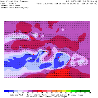
Current wind map shows:
- a small fetch in the NW corner
- the windswell fetch
- a very strong fetch in the Tasman Sea. Fiji has been pumping and that is going to be another out of season massive swell. Got some spare change? Book yourself a flight for next week if you can handle 10f 15s at Cloudbreak on Wednesday.

NAM3km map at noon looks exactly like it has looked for this whole week and keeps showing strong easterly trades.

Thursday, November 24, 2016

11 24 16 morning call
Just a sunset surf session at Hookipa for me yesterday. Waves were fun because the wind finally released the strong grip it had all day, morning included.
The windsurfing conditions are illustrated best by this photo by Jimmie Hepp from this gallery: some size, but the shape heavily influenced by the elevated windswell.

Much cleaner (but smaller) were the waves at Honolua Bay where, as predicted, they started the ladies contest and ran it all day. Photo WSL / Poullenot/Aquashot from this gallery.

4am significant buoy readings
South shore
Lanai
1.5ft @ 15s from 230° (SW)
There we go, the SW energy coming from the fetch that a week ago was in the Tasman Sea took its time, but it's now filled in better.I think I'll teach my lesson this morning! But I'll know for sure only after I check the lahaina webcam and you should do the same if you have interest in surfing down there.
North shore
NW
9.2ft @ 10s from 94° (E)
N
9.2ft @ 9s from 70° (ENE)
Hanalei
4.9ft @ 11s from 17° (NNE)
Pauwela
7.4ft @ 9s from 65° (ENE)


NAM3km map at noon shows strong easterly trades.

PS. I don't celebrate any day in particular (including my birthday, Christmas and other non senses alike... I celebrate every single day instead), but someone thought to wish me a happy thanksgiving on facebook and that reminded me that the 8th or 9th annual Paia Bay Invitational friendly surf contest will be on at some point in the late morning at Paia Bay. 8th or 9th cracks me up and it's totally in line with the spirit of this very non competitive get together event.
The windsurfing conditions are illustrated best by this photo by Jimmie Hepp from this gallery: some size, but the shape heavily influenced by the elevated windswell.

Much cleaner (but smaller) were the waves at Honolua Bay where, as predicted, they started the ladies contest and ran it all day. Photo WSL / Poullenot/Aquashot from this gallery.

4am significant buoy readings
South shore
Lanai
1.5ft @ 15s from 230° (SW)
There we go, the SW energy coming from the fetch that a week ago was in the Tasman Sea took its time, but it's now filled in better.I think I'll teach my lesson this morning! But I'll know for sure only after I check the lahaina webcam and you should do the same if you have interest in surfing down there.
North shore
NW
9.2ft @ 10s from 94° (E)
N
9.2ft @ 9s from 70° (ENE)
3.7ft @ 12s from 351° (N)
Hanalei
4.9ft @ 11s from 17° (NNE)
Pauwela
7.4ft @ 9s from 65° (ENE)
4.5ft @ 12s from 350° (N)
Yesterday's NNW swell turned N and disappeared at the NW buoy, probably overwhelmed by the massive windswell up there. But it's still at the other buoys and in Maui it reads 4.5f 12s from 350.
Below is the graph of the Pauwela buoy, and we can see that the swell did exactly what it was forecasted to do and peaked yesterday. I drew with the red dotted line what it's gonna do today, so I highly doubt the contest will be on today. But they also have a very unfavorable forecast (they will never tell you that in the webcast), so completing round 2 in the morning it's actually not completely out of the question. Check the dawn patrol show at 7.30am on the contest page.
Below is the graph of the Pauwela buoy, and we can see that the swell did exactly what it was forecasted to do and peaked yesterday. I drew with the red dotted line what it's gonna do today, so I highly doubt the contest will be on today. But they also have a very unfavorable forecast (they will never tell you that in the webcast), so completing round 2 in the morning it's actually not completely out of the question. Check the dawn patrol show at 7.30am on the contest page.

Current wind map shows:
- a small and distant fetch in the NW corner
- a tiny NNE fetch in the Gulf of Alaska
- the windswell fetch staying strong
- a couple of fetches down under
- a small and distant fetch in the NW corner
- a tiny NNE fetch in the Gulf of Alaska
- the windswell fetch staying strong
- a couple of fetches down under

NAM3km map at noon shows strong easterly trades.

PS. I don't celebrate any day in particular (including my birthday, Christmas and other non senses alike... I celebrate every single day instead), but someone thought to wish me a happy thanksgiving on facebook and that reminded me that the 8th or 9th annual Paia Bay Invitational friendly surf contest will be on at some point in the late morning at Paia Bay. 8th or 9th cracks me up and it's totally in line with the spirit of this very non competitive get together event.
Subscribe to:
Posts (Atom)


