
Monday, October 31, 2016
10 31 16 morning call
A surf and a windsurf session for me yesterday, both excellent.
The surfing was at Honolua. Here's a couple of shots I quickly took before getting in the water.
The Point offered the occasional shoulder high rippable wall.

You guys ever tried to ride an alaia? I did and good luck is all I can wish you.

The waves were waist to shoulder high and I took the longboard out and sat at the cave with something like 6 other guys. Within 15 minutes they all left and I had it to myself for an hour, before being joined by two young, beautiful, graceful and talented longboarder chicks. It was a rare occasion in which I enjoyed having company more than being by myself. This was one of them...

Completely satisfied by the surf session, I drove back to the north shore with the intention of checking out the windsurfing conditions. I hit the water around 4.30, right after a big squall hit and killed the wind just enough for my taste. Light sideoff and and head to logo high made for conditions that I ranked with a solid 9. I had a wave that was so good that got me screaming while kicking out.
This photo is from this gallery by Jimmie Hepp.

3am significant buoy readings
South shore
Lanai
1.1ft @ 13s from 207° (SSW)
Also today the energy from the south is minimal.
North shore
N
4.3ft @ 12s from 347° (NNW)
Waimea
3ft @ 11s from 353° (N)
Pauwela
6.9ft @ 8s from 66° (ENE)
Northerly swell went down 1 foot and 1 second compared to yesterday, but with 3f 12s still in the water there will be plenty waves on offer for the first day of the 2016 Aloha Classic.
Here's a quick chat I had with Robby Naish while he was rigging his sail.
"Robby, you gonna do the contest?"
"I don't think so"
"You're not back a hundred percent yet?"
"Not even close"
"How long has it been since you got injured?"
"5 months"
"Well, you're just as old as me I think and that doesn't help..."
"Yeah, you heal slower at our age"
He should be ok by 2038 though. That's when I'm going to organize the world championship of surfing for surfers of class 1963. I seriously plan on being the best 75 year old surfer on the planet by then. Location to be announced. Most likely Launiupoko...
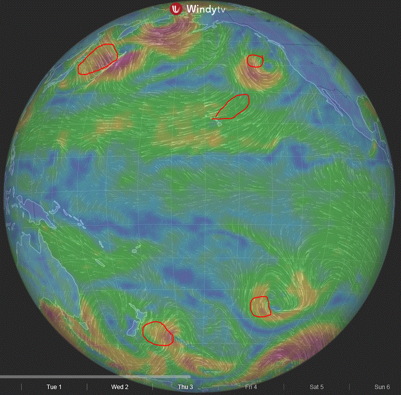
Current wind map shows the strong fetch that will send us a massive NW swell on Thursday. Surfline is calling for 12.6f 15s from 337 at 8am and I'm calling three-four times overhead at the Bay if that happens. The center of the low pressure is 956mb and all the west coast of the mainland will be hammered too. There's an even bigger swell forecasted for Tuesday the 8th, but it's too early for that.
Both this swells will be too big to sail Hookipa IMO (In My Opinion), but you never know. The level of the pro's is ridiculously high.

NAM3km map at noon shows: you guessed it again.

The surfing was at Honolua. Here's a couple of shots I quickly took before getting in the water.
The Point offered the occasional shoulder high rippable wall.

You guys ever tried to ride an alaia? I did and good luck is all I can wish you.

The waves were waist to shoulder high and I took the longboard out and sat at the cave with something like 6 other guys. Within 15 minutes they all left and I had it to myself for an hour, before being joined by two young, beautiful, graceful and talented longboarder chicks. It was a rare occasion in which I enjoyed having company more than being by myself. This was one of them...

Completely satisfied by the surf session, I drove back to the north shore with the intention of checking out the windsurfing conditions. I hit the water around 4.30, right after a big squall hit and killed the wind just enough for my taste. Light sideoff and and head to logo high made for conditions that I ranked with a solid 9. I had a wave that was so good that got me screaming while kicking out.
This photo is from this gallery by Jimmie Hepp.

3am significant buoy readings
South shore
Lanai
1.1ft @ 13s from 207° (SSW)
Also today the energy from the south is minimal.
North shore
N
4.3ft @ 12s from 347° (NNW)
Waimea
3ft @ 11s from 353° (N)
Pauwela
6.9ft @ 8s from 66° (ENE)
4.3ft @ 7s from 71° (ENE)
3.2ft @ 12s from 11° (NNE)
2.3ft @ 11s from 14° (NNE)
Northerly swell went down 1 foot and 1 second compared to yesterday, but with 3f 12s still in the water there will be plenty waves on offer for the first day of the 2016 Aloha Classic.
Here's a quick chat I had with Robby Naish while he was rigging his sail.
"Robby, you gonna do the contest?"
"I don't think so"
"You're not back a hundred percent yet?"
"Not even close"
"How long has it been since you got injured?"
"5 months"
"Well, you're just as old as me I think and that doesn't help..."
"Yeah, you heal slower at our age"
He should be ok by 2038 though. That's when I'm going to organize the world championship of surfing for surfers of class 1963. I seriously plan on being the best 75 year old surfer on the planet by then. Location to be announced. Most likely Launiupoko...
Current wind map shows the strong fetch that will send us a massive NW swell on Thursday. Surfline is calling for 12.6f 15s from 337 at 8am and I'm calling three-four times overhead at the Bay if that happens. The center of the low pressure is 956mb and all the west coast of the mainland will be hammered too. There's an even bigger swell forecasted for Tuesday the 8th, but it's too early for that.
Both this swells will be too big to sail Hookipa IMO (In My Opinion), but you never know. The level of the pro's is ridiculously high.

NAM3km map at noon shows: you guessed it again.

Sunday, October 30, 2016

10 30 16 morning call
Two surfs at Hookipa for me yesterday, both poor.
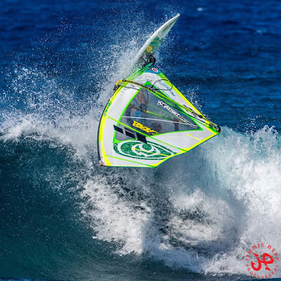
While chatting with some friends in the afternoon, I took this photo of windsurfer Jaeger Stone riding a wave. I tried to crop the toilets out, but I like it better like this.

The PWA wave contest at La Torche wasn't held and all the PWA sailors are now in town for their last contest of the season that is associated with the Aloha Classic.
Current leader of the rankings is Victor Fernandez and the only way that number two Alex Mussolini can clinch the title is if he wins the Aloha and Victor finishes 4th or worse.
Despite the great effort the organizers put into it and without lacking respect to them and to the competitors, unfortunately the PWA tour remains a bit lame IMO, since for sponsor reasons they have to stick to sites that do not offer the best wave riding conditions in the world.
The surfing pro WSL tour have a bunch of events in great spots with the exception of Brasil. In the PWA, it's like it's all Brasil with the exception of Maui.
But we all know how much more money is involved into the surfing world and that obviously makes the difference.
Anyway, with the Aloha starting tomorrow, I'll post a dedicated long term forecast in the second half of this call, but now let's see what's on offer today.
6am significant buoy readings
South shore
Lanai
0.9ft @ 14s from 219° (SW)
Tiny stuff on the south shore. Check the Lahaina webcam for details.
North Shore
NW
3.8ft @ 12s from 340° (NNW)
N
5.1ft @ 14s from 336° (NNW)
Pauwela
7.1ft @ 8s from 49° (NE)

The AWT contest has many age categories (thank god!) while both the AWT and PWA pro's will be in the same bracket (24 men each). As I mentioned, there will be trails for the pro's out of which 7 sailors will advance to the main event. Registration is still open tonight and you can sign up at the Rock'n'Brews in Paia, starting at 6pm.
One last thing to point out about this map is that southerly fetch. Let's see if something materializes at the Lanai buoy in a couple of more days.


PS. today I already did a 6am beach report and you'll find it just below this call.
While chatting with some friends in the afternoon, I took this photo of windsurfer Jaeger Stone riding a wave. I tried to crop the toilets out, but I like it better like this.

The PWA wave contest at La Torche wasn't held and all the PWA sailors are now in town for their last contest of the season that is associated with the Aloha Classic.
Current leader of the rankings is Victor Fernandez and the only way that number two Alex Mussolini can clinch the title is if he wins the Aloha and Victor finishes 4th or worse.
Despite the great effort the organizers put into it and without lacking respect to them and to the competitors, unfortunately the PWA tour remains a bit lame IMO, since for sponsor reasons they have to stick to sites that do not offer the best wave riding conditions in the world.
The surfing pro WSL tour have a bunch of events in great spots with the exception of Brasil. In the PWA, it's like it's all Brasil with the exception of Maui.
But we all know how much more money is involved into the surfing world and that obviously makes the difference.
Anyway, with the Aloha starting tomorrow, I'll post a dedicated long term forecast in the second half of this call, but now let's see what's on offer today.
6am significant buoy readings
South shore
Lanai
0.9ft @ 14s from 219° (SW)
Tiny stuff on the south shore. Check the Lahaina webcam for details.
North Shore
NW
3.8ft @ 12s from 340° (NNW)
N
5.1ft @ 14s from 336° (NNW)
3.4ft @ 10s from 356° (N)
Waimea
2.7ft @ 11s from 358° (N)
Waimea
2.7ft @ 11s from 358° (N)
2.7ft @ 13s from 327° (NW)
Pauwela
7.1ft @ 8s from 49° (NE)
3.5ft @ 13s from 348° (NNW)
2.5ft @ 11s from 14° (NNE)
I was incorrect yesterday by stating that the WNW swell would not get any more north. And that was because I incorrectly recalled what the fetch did. In other words, the shit I was trying to give you guys to encourage you to remember the wind maps, came straight back at me.
I was incorrect yesterday by stating that the WNW swell would not get any more north. And that was because I incorrectly recalled what the fetch did. In other words, the shit I was trying to give you guys to encourage you to remember the wind maps, came straight back at me.
Lesson learned, let's have a look at what really happened by analyzing the wind maps starting from Oct 25th. It's not gonna be easy, because we had a bunch of scattered sources.
In this one, the fetch off Kamchatka is the one that provided yesterday's WNW swell, IMO.

In this one, the fetch off Kamchatka is the one that provided yesterday's WNW swell, IMO.

That fetch was quickly pushed north of the Aleutians by a building high and disappeared on the map of Oct 26th below. All that was left was a small area of wave production NNW of us and that is the explanation for the more northerly direction at the buoys today.

On Oct 27 (map below) the wave generation in the northern hemisphere was minimal and confined to the area east of Kamchatka and to the windswell. That should be reflected in the water tomorrow, which is going to be the smallest day of the whole waiting period of the contest. It's most definitely not going to be flat (windswell still up), so I see it as a perfect day for running the youth and/or the trials of the pros and/or whatever other weak categories.
Head judge Duncan Coombs might also choose to call it off, since he can only use 11 days out of the long waiting period, but that would be a mistake IMO, since Monday and Tuesday will be the only relatively small days before the waves get much bigger. At the moment, only in the very last couple of days (Nov 12 and 13) the waves should go down to a level doable by the common mortals, but that of course can change.
The AWT contest has many age categories (thank god!) while both the AWT and PWA pro's will be in the same bracket (24 men each). As I mentioned, there will be trails for the pro's out of which 7 sailors will advance to the main event. Registration is still open tonight and you can sign up at the Rock'n'Brews in Paia, starting at 6pm.
One last thing to point out about this map is that southerly fetch. Let's see if something materializes at the Lanai buoy in a couple of more days.

The map of Oct 28 shows again a strong fetch in the NW corner. That is going to be responsible for the first NW swell of the contest. Arrival time is still a bit unclear, might be as early as Tuesday afternoon. By Wednesday it should be already logo to mast high.

It appears that that first punch shouldn't be too long lasting, since that fetch once again kinda disappeared on the Oct 29 map, but the usual NW corner was already putting a new bullet in the chamber...

...which is clearly visible on today's map: 12f 15s forecasted by Surfline for Thursday Nov 3rd seem a tad over estimated, but if it's gonna happen, they better move the contest at Jaws... I'm sure Polakow wouldn't mind that.

Back to back NW swells, but what about the wind? According to the latest forecast, it should be windy the whole way through. Pretty much as good as it gets for a wave sailing contest, once again Maui will not disappoint.


Today's NAM3km close up shows: you guessed it.

PS. today I already did a 6am beach report and you'll find it just below this call.

Saturday, October 29, 2016
10 29 16 morning call
Just a quick but sweet windsurf session for me yesterday.
When I came out of the water, Kauli was getting ready to go and asked me the usual:"how was it?"
"There's some clean sections" was my reply.
I took this photo from my car just before leaving to go to work and it looks like he found one of them.
As you can see from this photo from this gallery by Jimmie Hepp, the conditions weren't exactly epic, but as long as the wind was light enough (that usually happens after the squalls), the waves were relatively clean.

Here's a little comment-based conversation I had with a friend of mine on facebook, that I'm gonna use to clarify to my readers my apparently controversial position towards the wind and the wind related sports.
She's an avid kiter and she posted:
Dear Wind: I am thankful for the stoke you have given me. 💫 💨
💨
Your existence is a condition for my happiness 😊. I pray for you being in my life..
I commented (the fact that she's pretty hot helped, of course):"That's what I felt 15 years ago when I moved here. Now I can barely tolerate it. Funny how things change.
Fortunately I still have plenty things to be thankful for."
She replied:"GP! how come?.."
And I replied:"Surfing made me appreciate clean waves. And, unless it's light offshore, the wind doesn't help that. But it's all good. I know where to find clean waves even the trades blowing relentlessly. Most times, at least... :)"
5am significant buoy readings
South shore
Lanai
0.9ft @ 14s from 203° (SSW)
Very minimal energy at the Lanai buoy. As usual, check the webcam to see if it is worth it for you.
North shore
NW

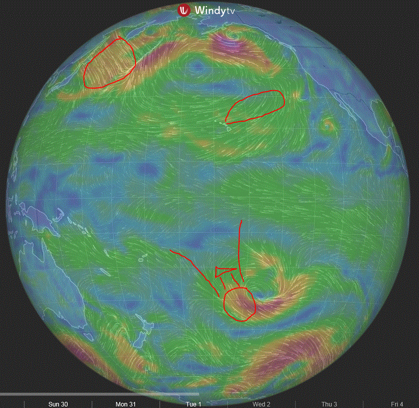
Current wind map shows the K fetch still there, the windswell fetch, a tiny fetch associated with that storm still brewing in the gulf of Alaska and a couple of minor fetches down south.

Am I still calling the models wrong? It's possible. Maybe one day I'll learn that this is the NAM3km one at noon: windy.

Last, but most definitely not least, it was a great pleasure to hug my shark attack victim friend at Hookipa yesterday. He's out of the hospital, the surgeon did reattach one tendon that had been lacerated and the chances of complete healing are pretty high.
That was the strongest hug I gave to a male human being since a long time. I should remember to give my dad a similar one next one I go back to Italy.
When I came out of the water, Kauli was getting ready to go and asked me the usual:"how was it?"
"There's some clean sections" was my reply.
I took this photo from my car just before leaving to go to work and it looks like he found one of them.

As you can see from this photo from this gallery by Jimmie Hepp, the conditions weren't exactly epic, but as long as the wind was light enough (that usually happens after the squalls), the waves were relatively clean.

Here's a little comment-based conversation I had with a friend of mine on facebook, that I'm gonna use to clarify to my readers my apparently controversial position towards the wind and the wind related sports.
She's an avid kiter and she posted:
Dear Wind: I am thankful for the stoke you have given me. 💫
Your existence is a condition for my happiness
I commented (the fact that she's pretty hot helped, of course):"That's what I felt 15 years ago when I moved here. Now I can barely tolerate it. Funny how things change.
Fortunately I still have plenty things to be thankful for."
She replied:"GP! how come?.."
And I replied:"Surfing made me appreciate clean waves. And, unless it's light offshore, the wind doesn't help that. But it's all good. I know where to find clean waves even the trades blowing relentlessly. Most times, at least... :)"
5am significant buoy readings
South shore
Lanai
0.9ft @ 14s from 203° (SSW)
Very minimal energy at the Lanai buoy. As usual, check the webcam to see if it is worth it for you.
North shore
NW
7.4ft @ 8s from 84° (E)
3.4ft @ 14s from 300° (WNW)
3.2ft @ 11s from 32° (NE)
Waimea
3.1ft @ 11s from 16° (NNE)
3.1ft @ 11s from 16° (NNE)
1.8ft @ 16s from 315° (NW)
Pauwela
6.4ft @ 8s from 57° (ENE)
Well, as confirmed also in the current wind map down below, once again that fetch didn't move much and stayed confined in the original region of appearance.
That means the following things:
- the swell is going to be pretty west (300 degrees at the NW buoy) and as such blocked by the upstream islands.
- the swell is not going to become more north (at least for the next few days).
The 337 direction at the Pauwela buoy is a total glitch. Buoys do that sometimes, but I usually don't get fooled, because... I remember the fetches!
Btw, the last recent WNW swell did just that, but it was much bigger, because the wind in the fetch was much stronger.
Anyway, similar conditions to yesterday at Hookipa, with the addition of some westerly lines here and there. On the morning call of 10 26, I wrote: "Current wind map shows scattered fetches all over. Remember, the fetches configuration will be reflected in the water a few days later."
That's what we'll have today. A bit of energy from all over the place (I don't even feel like mentioning that hurricane Seymour, because I don't think we'll see much from it).
6.4ft @ 8s from 57° (ENE)
3.6ft @ 11s from 22° (NNE)
1.3ft @ 16s from 337° (NNW)
The last couple of days have been ruled by the windswell and the mid period energy coming off that fetch in the gulf of Alaska. They are both still there, but today a new source will add on top.
You guys remember that fetch that started appearing off Kamchatka about four days ago?
I must have used the word Kamchatka in each single of the past four days, you guys MUST remember that fetch! Sorry, that's my weird way of trying to train you guys to remember the wind maps and the associated fetches. That's how, IMO, you have an idea of what's coming, from where and with what characteristics.
Well, as confirmed also in the current wind map down below, once again that fetch didn't move much and stayed confined in the original region of appearance.
That means the following things:
- the swell is going to be pretty west (300 degrees at the NW buoy) and as such blocked by the upstream islands.
- the swell is not going to become more north (at least for the next few days).
The 337 direction at the Pauwela buoy is a total glitch. Buoys do that sometimes, but I usually don't get fooled, because... I remember the fetches!
Btw, the last recent WNW swell did just that, but it was much bigger, because the wind in the fetch was much stronger.
Anyway, similar conditions to yesterday at Hookipa, with the addition of some westerly lines here and there. On the morning call of 10 26, I wrote: "Current wind map shows scattered fetches all over. Remember, the fetches configuration will be reflected in the water a few days later."
That's what we'll have today. A bit of energy from all over the place (I don't even feel like mentioning that hurricane Seymour, because I don't think we'll see much from it).
Below is the graph of the NW buoy that shows that this swell seems to have peaked already at just below 4f. So it's not gonna be more than 3f in Maui.

Current wind map shows the K fetch still there, the windswell fetch, a tiny fetch associated with that storm still brewing in the gulf of Alaska and a couple of minor fetches down south.
Am I still calling the models wrong? It's possible. Maybe one day I'll learn that this is the NAM3km one at noon: windy.
Last, but most definitely not least, it was a great pleasure to hug my shark attack victim friend at Hookipa yesterday. He's out of the hospital, the surgeon did reattach one tendon that had been lacerated and the chances of complete healing are pretty high.
That was the strongest hug I gave to a male human being since a long time. I should remember to give my dad a similar one next one I go back to Italy.
Friday, October 28, 2016
10 28 16 morning call
An early morning surf session in Lahaina was my water time yesterday.
The Bay was tiny (made for an epic nap on the cliff though) and the north shore didn't inspire me a bit.
It didn't inspire Jimmie either, who wisely chose to stay home dry. Photo of the day is by Ben Thouard and it shows why I haven't gone to Tahiti yet and I won't for a while: too freaking shallow. My surfing is not up for that yet. The fact that Indo is at least 10 times cheaper also plays a key role.

4am significant buoy readings
South shore
Lanai
0.8ft @ 15s from 212° (SW)
Barbers
1.7ft @ 11s from 199° (SSW)
North Shore
Pauwela
7.3ft @ 8s from 45° (NE)
Current wind map shows a pretty wide NW fetch, a windswell one and a couple of small ones in the southern hemisphere.
The NW one will send us 5f 15s on Tuesday, day 2 of the upcoming Aloha Classic (you can register here). Much bigger waves for the rest of that week.

I need to apologize since I've done a bit of confusion with these wind models. This is the NAM one and it's the best one I've found in the absence of the MC2km one. It shows plenty wind at noon. Original direction is pretty easterly, look how much stronger (and gustier) it gets after being accelerated on the NE facing slopes of Haleakala. It gets even stronger after being accelerated on the SE facing slopes of Haleakala. That coast line offers stronger and more consistent wind than the north shore. Imagine that. Also, no trades in Kihei with this direction.

The Bay was tiny (made for an epic nap on the cliff though) and the north shore didn't inspire me a bit.
It didn't inspire Jimmie either, who wisely chose to stay home dry. Photo of the day is by Ben Thouard and it shows why I haven't gone to Tahiti yet and I won't for a while: too freaking shallow. My surfing is not up for that yet. The fact that Indo is at least 10 times cheaper also plays a key role.

4am significant buoy readings
South shore
Lanai
0.8ft @ 15s from 212° (SW)
0.8ft @ 11s from 202° (SSW)
Barbers
1.7ft @ 11s from 199° (SSW)
0.9ft @ 15s from 211° (SW)
Small readings at the south buoys, but not flat. It's always worth to have a look at the webcam. Looks real tiny today.North Shore
Pauwela
7.3ft @ 8s from 45° (NE)
2.8ft @ 11s from 9° (N)
All about the windswell on the north shore today.Current wind map shows a pretty wide NW fetch, a windswell one and a couple of small ones in the southern hemisphere.
The NW one will send us 5f 15s on Tuesday, day 2 of the upcoming Aloha Classic (you can register here). Much bigger waves for the rest of that week.

I need to apologize since I've done a bit of confusion with these wind models. This is the NAM one and it's the best one I've found in the absence of the MC2km one. It shows plenty wind at noon. Original direction is pretty easterly, look how much stronger (and gustier) it gets after being accelerated on the NE facing slopes of Haleakala. It gets even stronger after being accelerated on the SE facing slopes of Haleakala. That coast line offers stronger and more consistent wind than the north shore. Imagine that. Also, no trades in Kihei with this direction.

Thursday, October 27, 2016
10 27 16 morning call
Double surf session in Lahaina for me yesterday, the morning was absolutely pristine again.
I might have to start contemplating a move over there sooner or later.
As usual, the windsurfers hit the waves at Hookipa in the afternoon. This photo comes from this gallery by Jimmie Hepp.

4am buoy readings
South shore
Lanai
1.4ft @ 13s from 198° (SSW)
The swell that I've surfed the last three days is still hanging in there with 1.4f 13s, but now there's a new one with 1f 16s. I thought I was gonna stay on the north shore today, but that makes me question that decision. That's why it's pointless to do surfing plans in the evening. And that's why this is called the morning call. You need to check the latest available info and then decide.
North shore
NW
5.1ft @ 10s from 7° (N)
N
4.9ft @ 13s from 314° (NW)
Current wind map shows a wide, but far and not too strong fetch off Kamchatka, the windswell fetch and an interesting one down south creating an extremely rare SE swell. It's gonna be mostly south by the time the angular spreading will bend the waves our way. I like it because it sits around 30 degrees south and that is a lot closer than where the south swell fetches usually sit. We'll see what we get in 5-6 days.

MC2km maps still unreachable, this is the HRW model at noon today. Should be windy again. What a news! This has been one of the windiest October I can remember. Maybe not always strong and not always from the right direction, but the trades blew relentless. They blew out the waves relentless too.
Looking forward to the first glassy day on the north shore of the season, but it doesn't look like it's gonna happen anytime soon. In the meantime, I don't mind driving around the corner to get my share of glassiness.

I might have to start contemplating a move over there sooner or later.
As usual, the windsurfers hit the waves at Hookipa in the afternoon. This photo comes from this gallery by Jimmie Hepp.

4am buoy readings
South shore
Lanai
1.4ft @ 13s from 198° (SSW)
1ft @ 16s from 220° (SW)
The swell that I've surfed the last three days is still hanging in there with 1.4f 13s, but now there's a new one with 1f 16s. I thought I was gonna stay on the north shore today, but that makes me question that decision. That's why it's pointless to do surfing plans in the evening. And that's why this is called the morning call. You need to check the latest available info and then decide.
North shore
NW
5.1ft @ 10s from 7° (N)
N
4.9ft @ 13s from 314° (NW)
4.1ft @ 10s from 4° (N)
4ft @ 7s from 16° (NNE)
Waimea
3.5ft @ 13s from 314° (NW)
Terrible mix of periods and directions at the northerly facing buoys. The NW energy is supposed to slowly die, while the 10s period one from the north should stay pretty steady around 4f. If you don't remember the fetch where that comes from, you're a bit hopeless but lucky... just scroll down to a couple of days ago and you'll see it on the wind map in the gulf of Alaska.Waimea
3.5ft @ 13s from 314° (NW)
3.4ft @ 9s from 3° (N)
Pauwela
Pauwela
4.1ft @ 10s from 6° (N)
3.9ft @ 7s from 31° (NE)
3.1ft @ 13s from 327° (NW)
Current wind map shows a wide, but far and not too strong fetch off Kamchatka, the windswell fetch and an interesting one down south creating an extremely rare SE swell. It's gonna be mostly south by the time the angular spreading will bend the waves our way. I like it because it sits around 30 degrees south and that is a lot closer than where the south swell fetches usually sit. We'll see what we get in 5-6 days.
MC2km maps still unreachable, this is the HRW model at noon today. Should be windy again. What a news! This has been one of the windiest October I can remember. Maybe not always strong and not always from the right direction, but the trades blew relentless. They blew out the waves relentless too.
Looking forward to the first glassy day on the north shore of the season, but it doesn't look like it's gonna happen anytime soon. In the meantime, I don't mind driving around the corner to get my share of glassiness.

Wednesday, October 26, 2016

10 26 16 morning call
Double surf session in Lahaina for me yesterday.
The first hour of the first one was a 9 and thanks to my Little Rascal I produced my best surfing ever and that is a damn good feeling.
Meanwhile the WNW swell was hitting the north shore and as predicted Hookipa got plenty size in the afternoon. This is Kauli Seadi in a photo from this gallery by Jimmie Hepp. He stopped by the shop later and declared:"Hookipa was amazing this afternoon!"
Jimmie also went to visit the shark attack victim at the hospital. He is doing great and he'll have another surgery Friday to reattach the tendons of the hand. Best luck to you hermano! I hope you'll be able to give left hand shaka signs very soon.

4am significant buoy readings
Lanai
1.8ft @ 13s from 191° (SSW)
The Barbers buoy is all confused by the wrap of the WNW swell and gives no indication of the south swell. We don't need it, we got it at the Lanai one.
There will be really good waves to surf this morning on the north shore, but I can't wait to catch a few more of those perfect shape shoulder high peelers in Lahaina, so call me weird, but I'll probably do the drive in the dark again. Those waves improve my surfing much more than the north shore ones. And that is something that I also know from 15 years of teaching water sports: the easier the conditions, the faster the improvement, without a doubt. But overall, I just have more fun over there!
Below is the wind map of 7 days ago. It's called: in the cock roach antennas we trust.

NW

Current wind map shows scattered fetches all over. Remember, the fetches configuration will be reflected in the water a few days later. In this particular case, only the windswell fetch might do something noticeable for us as Pat Caldwell also points out: "Surf from windswell should build above average by late Thursday and remain elevated near to just above average through the weekend from 60-90 degrees"
The fetch associated with hurricane Seymore (straight east of us) is really minor at the moment.

HWR model at noon shows trades from a decent direction. Is it really gonna be only 13 knots? Of course not. If the sky is clear, the heating of the Haleakala will add the usual boost and it should be another good day of windsurfing/kitesurfing on the north shore.

----------------------------------------------------------------------------------
5.30am update
As I was about to leave, somehow my instinct told me to check the buoys on my phone one more time. Sure enough, the Lanai reading was different from what I remembered even though the time stamp was still 4am.
I still had the "old" screen open on my computer and below are the two different readings with the same time stamp.
The one I first saw (and copy/pasted above) is 1.8ft @ 13s from 191° (SSW). The "new" one is 1.4ft @ 13s from 193° (SSW). That's enough of a difference for me to make me choose to wait for the sun to come up and check the webcam before eventually going. I'll do that from Hookipa so expect a beach report from there.
That never happened before, I might have to send Surfline an email and ask for clarifications.

The first hour of the first one was a 9 and thanks to my Little Rascal I produced my best surfing ever and that is a damn good feeling.
Meanwhile the WNW swell was hitting the north shore and as predicted Hookipa got plenty size in the afternoon. This is Kauli Seadi in a photo from this gallery by Jimmie Hepp. He stopped by the shop later and declared:"Hookipa was amazing this afternoon!"

Jimmie also went to visit the shark attack victim at the hospital. He is doing great and he'll have another surgery Friday to reattach the tendons of the hand. Best luck to you hermano! I hope you'll be able to give left hand shaka signs very soon.

4am significant buoy readings
Lanai
1.8ft @ 13s from 191° (SSW)
The Barbers buoy is all confused by the wrap of the WNW swell and gives no indication of the south swell. We don't need it, we got it at the Lanai one.
There will be really good waves to surf this morning on the north shore, but I can't wait to catch a few more of those perfect shape shoulder high peelers in Lahaina, so call me weird, but I'll probably do the drive in the dark again. Those waves improve my surfing much more than the north shore ones. And that is something that I also know from 15 years of teaching water sports: the easier the conditions, the faster the improvement, without a doubt. But overall, I just have more fun over there!
Below is the wind map of 7 days ago. It's called: in the cock roach antennas we trust.

NW
5.5ft @ 14s from 310° (WNW)
Waimea
6.3ft @ 15s from 307° (WNW)
Pauwela
3.9ft @ 15s from 305° (WNW)
6.3ft @ 15s from 307° (WNW)
Pauwela
3.9ft @ 15s from 305° (WNW)
The graphs of the NW, Waimea and Pauwela buoys below deserve some comments. Notice how the blue line indicating the direction at the first one didn't change. As explained on yesterday's post, the fetch didn't move much and staying confined in the Kamchatka corner before being pushed up north over the Aleutians disappearing from the Hawaii swell window. As a result, the direction of this swell is staying steady from around 300-310.
Also notice how much more size Oahu got (and Kauai must have been even bigger). I was watching the Pipeline webcam and I saw some sets breaking at the second reef... lots of water moving. No wonder with 7f 17s in the water!
In Maui we only got up to 4f and that's because some of the energy got blocked by the upstream islands of Oahu and Molokai.

Current wind map shows scattered fetches all over. Remember, the fetches configuration will be reflected in the water a few days later. In this particular case, only the windswell fetch might do something noticeable for us as Pat Caldwell also points out: "Surf from windswell should build above average by late Thursday and remain elevated near to just above average through the weekend from 60-90 degrees"
The fetch associated with hurricane Seymore (straight east of us) is really minor at the moment.

HWR model at noon shows trades from a decent direction. Is it really gonna be only 13 knots? Of course not. If the sky is clear, the heating of the Haleakala will add the usual boost and it should be another good day of windsurfing/kitesurfing on the north shore.

----------------------------------------------------------------------------------
5.30am update
As I was about to leave, somehow my instinct told me to check the buoys on my phone one more time. Sure enough, the Lanai reading was different from what I remembered even though the time stamp was still 4am.
I still had the "old" screen open on my computer and below are the two different readings with the same time stamp.
The one I first saw (and copy/pasted above) is 1.8ft @ 13s from 191° (SSW). The "new" one is 1.4ft @ 13s from 193° (SSW). That's enough of a difference for me to make me choose to wait for the sun to come up and check the webcam before eventually going. I'll do that from Hookipa so expect a beach report from there.
That never happened before, I might have to send Surfline an email and ask for clarifications.
Tuesday, October 25, 2016
10 25 16 morning call
Yesterday I had two surf sessions. In the first one I caught 6 waves in 30 minutes at Hookipa and didn't manage to do a single turn. For the second one I went to Lahaina and did multiple turns on each single wave I caught (waist to chest high).
Jimmie Hepp didn't post an album from yesterday, so I have no idea what happened on the north shore (and couldn't care less, to be honest with you). To grab a worthy photo I so went on the page of
photographer Ben Thouard, where of course I unwillingly learned who's the new WSL world champion. Bummer, it's so difficult to stay away from these kind of news. No problem, I'll enjoy watching the Portugal contest on demand no matter what, I still don't know who won that one. I just finished France yesterday...
Here's the Tahiti shot from Ben.

3am significant buoy readings
South shore
Lanai
1.9ft @ 14s from 191° (SSW)

Below is what Surfline predicts: 5f 15s at 8am tomorrow from 310. And that is size and direction they think it's going to have AFTER the refraction upon the upstream islands. They're usually pretty good, the Pauwela buoy will tell us in the next couple of days if they were right.
The graph also shows a pretty conservative 2.2f 18s at 2pm today. I think it might rise a bit more than that.

Current wind map shows the strong flow off Kamchatka (day 3 of that) and more northerly energy from that stubborn low up in the Gulf of Alaska. I also like that Maui is not immersed in an area of strong trades like it has been all last week. That should bring the windswell down. Only temporarily though, since the trades are about to crank up again. The forecast for the Aloha Cloassic looks really good with plenty wind and waves. Someone told me that in La Torche they got no wind insrtead.

So which of the wind models I posted yesterday was right? Well, not knowing what happened on the north shore, I'm not quite sure, but the iWindsurf graph of Hookipa yesterday seems to indicate some pretty strong wind gusting up to the 30's, and that makes me think that the best prediction was done by the HRW one.

Which is the one that I propose to you again. This is at noon today and it sure doesn't look like a particularly windy day.

Jimmie Hepp didn't post an album from yesterday, so I have no idea what happened on the north shore (and couldn't care less, to be honest with you). To grab a worthy photo I so went on the page of
photographer Ben Thouard, where of course I unwillingly learned who's the new WSL world champion. Bummer, it's so difficult to stay away from these kind of news. No problem, I'll enjoy watching the Portugal contest on demand no matter what, I still don't know who won that one. I just finished France yesterday...
Here's the Tahiti shot from Ben.

3am significant buoy readings
South shore
Lanai
1.9ft @ 14s from 191° (SSW)
0.5ft @ 20s from 274° (W)
Barbers
1.9ft @ 14s from 191° (SSW)
If you don't remember the position of the fetch that generated this powerful WNW swell, here's the map of October 21st, the day of the fetch's maximum strength. Because of the block of the strong high pressure to the right of it, that low never did what most lows up there do: it never travelled east and the swell is going to stay west the whole 2-3 days that it's going to last.1.9ft @ 14s from 191° (SSW)
1.2ft @ 18s from 325° (NW)
1.9f 14s from 191, this must be the very first time in which I see two identical readings at the two local south facing buoys! The other readings are the wrap of the WNW swell I'll talk about below and will have no effect on the waves in Lahaina. Eventually Kihei might get something, you need to check the webcams if you're interested in that.
Anyway, yesterday it was more like 1.5f 15s, so today it should be similar if not a tad bigger. I'm expecting waist to shoulder. I'll drive there for the dawn session, expect a more precise beach report (if I'll be able to see the waves in the dark...).
Anyway, yesterday it was more like 1.5f 15s, so today it should be similar if not a tad bigger. I'm expecting waist to shoulder. I'll drive there for the dawn session, expect a more precise beach report (if I'll be able to see the waves in the dark...).
North shore
NW
7.2ft @ 16s from 303° (WNW)
NW
7.2ft @ 16s from 303° (WNW)
Waimea
1.9ft @ 18s from 305° (WNW)
Pauwela
Below is the graph of the NW (right) and Pauwela (left) buoys. The red arrows indicate that the new WNW swell went from 1f to 6 at the NW one from noon to midnight yesterday. Considering the high period (18-20), a qualitatively similar increase should happen roughly 12 hours later at the Pauwela buoy, but seen the westerly original direction (303), the size will be quite different and hard to guess. My guess is around 4f at noon in Maui, we shall see.
Btw, how come there's no long period readings at Pauwela at 4am yet? There is, but the (stupid) automatic program only picks the highest 4 readings in size. So the 1.2ft @ 4s totally insignificant reading made the cut instead of the 0.5-0.7ft @ 20s from 315° we can see from the orange line on the Pauwela graph.

Here's a map that shows that the Molokai shadow line for Hookipa is around 305 degrees. That means that Hookipa is still going to probably get some size this afternoon and tomorrow. Not a good direction for Honolua instead (I had to disappoint some excited surf rental customers yesterday by revealing them that the shadow line for the Bay is 335), but it's possible that Wednesday the swell will be big enough to wrap around Molokai and squeeze in there. I have a temporary west side informer these days, hopefully he'll send me a report (thanks countryman!). If you want to learn more about the shadowing angles here's a post you might find interesting.
And if you're not familiar with the concept of refraction, here's the couple of posts that come out if you click on the label "refraction" in the labels section of this blog.

1.9ft @ 18s from 305° (WNW)
Pauwela
3.9ft @ 8s from 69° (ENE)
1.6ft @ 6s from 51° (ENE)
1.4ft @ 13s from 322° (NW)
1.2ft @ 4s from 53° (ENE)
Below is the graph of the NW (right) and Pauwela (left) buoys. The red arrows indicate that the new WNW swell went from 1f to 6 at the NW one from noon to midnight yesterday. Considering the high period (18-20), a qualitatively similar increase should happen roughly 12 hours later at the Pauwela buoy, but seen the westerly original direction (303), the size will be quite different and hard to guess. My guess is around 4f at noon in Maui, we shall see.
Btw, how come there's no long period readings at Pauwela at 4am yet? There is, but the (stupid) automatic program only picks the highest 4 readings in size. So the 1.2ft @ 4s totally insignificant reading made the cut instead of the 0.5-0.7ft @ 20s from 315° we can see from the orange line on the Pauwela graph.

Here's a map that shows that the Molokai shadow line for Hookipa is around 305 degrees. That means that Hookipa is still going to probably get some size this afternoon and tomorrow. Not a good direction for Honolua instead (I had to disappoint some excited surf rental customers yesterday by revealing them that the shadow line for the Bay is 335), but it's possible that Wednesday the swell will be big enough to wrap around Molokai and squeeze in there. I have a temporary west side informer these days, hopefully he'll send me a report (thanks countryman!). If you want to learn more about the shadowing angles here's a post you might find interesting.
And if you're not familiar with the concept of refraction, here's the couple of posts that come out if you click on the label "refraction" in the labels section of this blog.


Below is what Surfline predicts: 5f 15s at 8am tomorrow from 310. And that is size and direction they think it's going to have AFTER the refraction upon the upstream islands. They're usually pretty good, the Pauwela buoy will tell us in the next couple of days if they were right.
The graph also shows a pretty conservative 2.2f 18s at 2pm today. I think it might rise a bit more than that.

Current wind map shows the strong flow off Kamchatka (day 3 of that) and more northerly energy from that stubborn low up in the Gulf of Alaska. I also like that Maui is not immersed in an area of strong trades like it has been all last week. That should bring the windswell down. Only temporarily though, since the trades are about to crank up again. The forecast for the Aloha Cloassic looks really good with plenty wind and waves. Someone told me that in La Torche they got no wind insrtead.

So which of the wind models I posted yesterday was right? Well, not knowing what happened on the north shore, I'm not quite sure, but the iWindsurf graph of Hookipa yesterday seems to indicate some pretty strong wind gusting up to the 30's, and that makes me think that the best prediction was done by the HRW one.

Which is the one that I propose to you again. This is at noon today and it sure doesn't look like a particularly windy day.

Monday, October 24, 2016

10 24 16 morning call
Just one surf session for me yesterday, but a hell lot of house chores accomplished. You guys must be thrilled to learn that.
Here's a photo from this gallery by Jimmie Hepp that shows that Hookipa still had plenty size. Amazing what 3f 11s (plus windswell) can do when coming from an unblocked direction.

3-4am significant buoy readings
North shore
N
3.7ft @ 10s from 341° (NNW)
Pauwela
4.9ft @ 8s from 65° (ENE)
I actually like a lot better the map of the day after, October 18. That means that tomorrow this south swell should be stronger. 1.8f 15s predicted by Surfline.

Current wind map shows that fetch off Kamchatka getting bigger but not quite much stronger just yet and a tiny remnant of that gulf of Alaska fetch that has been providing this long lasting northerly energy.
Also a small fetch in the Tasman sea, but Fijian archipelago will probably block most of the energy. As a matter of fact, Surfline is calling for 6f 12s for down there between Thursday and Friday. Sounds like epic Restaurants to me! Mmm... maybe I should skip the windsurfing contest and get on a plane to catch that...

Without access to the MC2km website, I'm looking for alternatives.
Here's a couple of models available on the Windity page. This one is called ECMWF and is showing a direction of 60 degrees at noon at Hookipa.

This other one is the NAM3km and it shows 90 degrees instead. That's a huge gap and it's gonna be easy to verify which one was right... unless the direction will be 75, of course.

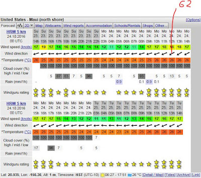
One more option: the HRW model at the very bottom of the Windguru page. That is calling for 62 degrees and a pretty solid cloud cover throughout all day. We shall see.
Here's a photo from this gallery by Jimmie Hepp that shows that Hookipa still had plenty size. Amazing what 3f 11s (plus windswell) can do when coming from an unblocked direction.

3-4am significant buoy readings
North shore
N
3.7ft @ 10s from 341° (NNW)
Pauwela
4.9ft @ 8s from 65° (ENE)
2.8ft @ 6s from 67° (ENE)
2.6ft @ 10s from 349° (NNW)
0.6ft @ 15s from 346° (NNW)
The usual mix of periods and directions at the Pauwela buoy, the ocean will reflect that. Pretty sure it's still head high out there, but it should be smaller than yesterday.
South shore
Lanai
South shore
Lanai
1.1ft @ 13s from 198° (SSW)
0.9ft @ 16s from 199° (SSW)
Barbers
1.4ft @ 16s from 197° (SSW)

1.4ft @ 16s from 197° (SSW)
1.4ft @ 12s from 193° (SSW)
Lovely small pulse of long period energy at the local south facing buoys, let's see where that is coming from. Seeing the fetch where a swell comes from for me is an absolutely key thing to do.
Lovely small pulse of long period energy at the local south facing buoys, let's see where that is coming from. Seeing the fetch where a swell comes from for me is an absolutely key thing to do.
If you surf that swell, in fact, you can learn what the length, width, overall area, intensity of the wind, distance of the fetch do to: size, consistency, number of waves in the set, etc.
It does take an analytical mind to do that, and probably 90% of the surfers won't care too much about it, but I'm sure there's some other weird guys like me out there.
It does take an analytical mind to do that, and probably 90% of the surfers won't care too much about it, but I'm sure there's some other weird guys like me out there.
Here's the map of 7 days ago, October 17 and here's what Pat Caldwell wrote on Friday: A gale low pressure moved slowly east along 45°S to the east of New Zealand to south of French Polynesia 10/17-20. The winds were magnitude deficient, so only a small event is expected locally. It should pick up Monday from 170-190 degrees, peak late Monday, then linger into Wednesday.
The fetch associated with the low he meant and the one responsible for the 16s readings is the lower one. It's likely that the one right north of it is the one adding the 13s energy.

I actually like a lot better the map of the day after, October 18. That means that tomorrow this south swell should be stronger. 1.8f 15s predicted by Surfline.

Current wind map shows that fetch off Kamchatka getting bigger but not quite much stronger just yet and a tiny remnant of that gulf of Alaska fetch that has been providing this long lasting northerly energy.
Also a small fetch in the Tasman sea, but Fijian archipelago will probably block most of the energy. As a matter of fact, Surfline is calling for 6f 12s for down there between Thursday and Friday. Sounds like epic Restaurants to me! Mmm... maybe I should skip the windsurfing contest and get on a plane to catch that...

Without access to the MC2km website, I'm looking for alternatives.
Here's a couple of models available on the Windity page. This one is called ECMWF and is showing a direction of 60 degrees at noon at Hookipa.

This other one is the NAM3km and it shows 90 degrees instead. That's a huge gap and it's gonna be easy to verify which one was right... unless the direction will be 75, of course.

One more option: the HRW model at the very bottom of the Windguru page. That is calling for 62 degrees and a pretty solid cloud cover throughout all day. We shall see.

Subscribe to:
Posts (Atom)


