Tuesday, November 18, 2014

11 18 14 morning call

4am main swell buoy readings:

Maui north shore
6.2ft @ 13s from 340° (NNW)           
5.7ft @ 10s from 344° (NNW)
2.9ft @ 6s from 20° (NNE)

West lanai
1.3ft @ 13s from 305° (WNW)           
1.2ft @ 10s from 277° (W)
1.1ft @ 4s from 170° (S)
0.7ft @ 18s from 215° (SW)

Sorry, but I do have to brag about yesterday's call. I wrote that the new swell was going to have a "steep climb around noon" and below is the graph of of the Maui buoy...
 

Which also tells us that there's still waves to be ridden. Not ideal weather for surfing (with the exception of Honolua Bay, of course), but windsurfers and kiters are going to be stoked all week.
After today, in fact, the waves will remain in the 4 feet range and the trade winds will be blowing pretty strong (particularly tomorrow).
A new bigger NW swell slotted for Sunday, with hopefully a lot less wind, but the week after that looks pretty horrible from the wind point of view. Which, you might want to remember this, in my case means strong wind. Too early to bitch about it now though.

The Lanai buoy is registering 0.7ft @ 18s from 215° (SW) in case you want to get out of the wind and go surf Lahaina.
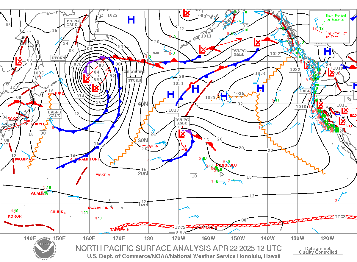
And in case you're wondering where is that coming from, here's the weather map of 7 days ago.
I circled in red the fetch in the Tasman sea, just east of New Zealand, that generated a big (I'm sure) swell for Fiji. We're just getting the leftovers...


Have fun in the sun everyone!

Monday, November 17, 2014

Fun size (head high in the sets) short period. Not windy and uncrowded. Both not gonna last long...

11 17 14 morning call

4am main swell buoy readings:

NW
8.7ft @ 14s from 343° (NNW)
5.4ft @ 10s from 339° (NNW)

Waimea
3.4ft @ 7s from 345° (NNW)
3.2ft @ 9s from 334° (NNW)
2.2ft @ 11s from 332° (NNW)
2ft @ 12s from 333° (NNW)

Maui north shore
5.2ft @ 9s from 342° (NNW)
1.3ft @ 3s from 53° (ENE)
   
 
New swell on the way as the graph of the NW buoy clearly shows below.

 
You wonder how long it takes from that buoy to Maui? Here's an article on surfline that answers that for Oahu. For Maui, you have to add another 100 nautical miles, which, in the case of the example of a 14s swell from 300 means 5 more hours for a total of 17h. But this one is from 343, so my guess is an approximate 12h and that means that its going to have a steep climb around noon.

Below is the wind map of maui county @ 2km at noon, which seems almost sailable. Should get better later, but today I work at 2pm, so forgive me if I focus on a possible windsurf session before work.


The wind is still from a more onshore direction than normal though, as the world wind map shows below, so we'll have to wait and see. In the meantime, the wind sensor at Hookipa reads 0 at 6am, so don't forget the down patrol surf session. 5.2ft @ 9s from 342° (NNW)  can be fun!
   
Have fun in the sun everyone!

Sunday, November 16, 2014

As predicted, the waves are shitty. But i can surf, so i'm stoked!

11 16 14 morning call

4am main swell buoy readings:

Maui north shore
4.5ft @ 13s from 335° (NNW)
3.1ft @ 9s from 343° (NNW)

West lanai
2ft @ 13s from 208° (SSW)

Waves went down to a really fun size, but the wind is about to turn north and ruin them.

Here's the wind map that shows the fetch of north wind very close to the islands.


The Maui county @ 2km map at 6am this morning, shows even better how close that fetch is, and active wind or not, you can imagine that the waves are not going to be clean as they have been for the past two days with the lovely light Kona offshore wind.
Talking about which, I'm glad I quickly recovered by my Charlie horse thingy. Yes I did miss the 2 best days of the year so far, but I'm just stoked I'm back in the water already!


They show the onshore setting in around 10-11am, so hit the waves as early as you can!


South shore:
Don't be fooled by the Lanai buoy reading, it's the wrap of the NNW swell. Too bad because I have a lesson on the south shore and would have not minded a little bump.
Well, below is the weather map from a week ago. I circled a fetch of favorable winds that back then did create some waves headed our way. Are they going to make it all the way up here?
What kind of wind and currents did they meet during their (roughly) 7 days long journey?
Will the angular spreading of the big NW swell we had all week interfere with them?
Me and my student are going to find out.
I might not be the best surf instructor in Maui (ok, ok, top 10...), but I bet not many know what's in the water more than me. And this blog's followers.


BTW, trade winds back on Tuesday, but already gone by Saturday/Sunday.

Have fun in the sun everyone!

Saturday, November 15, 2014

I like this photo much better...

Kona wind a tad stronger and waves a tad smaller than yesterday, but still totally epic. Can't believe i have to miss this...

11 15 14 morning call

 
4am main swell buoy readings:

Waimea
6ft @ 13s from 332° (NNW)

Maui north shore
6ft @ 13s from 333° (NNW)

Still 6f 13s for a swell that has lasted pretty much all week is not a bad number.
It is one of my favorite sizes to surf Lanes btw, even though I don't think I'll be able to do that this morning.
I was hit by my board surfing it yesterday and my leg is still a bit sore. Should be ok this afternoon or tomorrow though when the swell will still be around, but with onshore winds :(

Yesterday Hookipa was totally epic, the best day of the winter so far, without a doubt.

Not gonna bug you with weather maps today, just a shot I took of Charlie Smith.


What you need to know about today is that the wind is still going to be light kona (which means still epic surfing on the north shore) all day. Whoo-hoo!
Enjoy it until it lasts, because tomorrow it goes light onshore and that will turn it into shit.

Trade winds back from a regular ENE direction back around Tuesday/Wednesday for the happiness of the windsurfers/kitesurfers that don't surf (guys, do something about it!). But don't get too excited. It's winter and it's not gonna last long.
The magic alternating of surfing and windsurfing conditions is one of the reasons I love Maui so much.

Have fun in the sun everyone!


Friday, November 14, 2014

Offshore, big and dramatically beautiful.

4am main swell buoy readings:

NW Hawaii
9.2ft @ 12s from 328° (NW)

Waimea
7.7ft @ 13s from 337° (NNW)
2.4ft @ 10s from 333° (NNW)

Maui north shore
5.9ft @ 14s from 333° (NNW)
3.5ft @ 10s from 343° (NNW)

Two relevant things to point out today.
The swell is going to have a bump back up in size. That is shown in the picture below showing the NW buoy graph (from surfline link n.11 on the right).
Notice that the size went up, but not the period. Notice also the start of a second bump in the wee hours of today.


This is the Maui buoy graph instead showing the first bump hitting once again in the wee hours.


The other very important thing is the fact that the wind will be blowing Kona. Pretty much almost all waves on the north shore like that (as long as it's not too strong), there might be some barrels on offer. Good luck with that!
I clicked on maui's north shore and the map says 18km/h, which is 11m/h and that's what's blowing right now. I love that website (links n.2 and n.4 of the list to the right)
It shouldn't be enough for sailing, but unfortunately maui county @ 2km (link n.17) has not updated their map, so we can't be really sure.


Have fun in the sun everyone!
 
PS. Alternative definition of wee hours from dictionary.com: the time spent in your life peeing