Sometimes looks doable, but there's cleanup doh sets. Bit rainy and not particularly clean either.
Saturday, December 06, 2014
12 6 14 morning call
Maui north shore (indicative of what's in the water on Maui's north shore)
6.8ft @ 14s from 333° (NNW)
West lanai Maui north shore (indicative of what's in the water on Maui's south shore)
1.8ft @ 13s from 283° (WNW)
Yesterday was a big day and today will be too. It actually depends on what's big for you. 7f 14s is big for me. I'll have a look at Hookipa (photo coming up soon), but my guess is that I'll surf somewhere else.
This swell is slowly decreasing (but not much) all day and then tomorrow it's going to be way bigger (13f 14s).
It's December in Hawaii and it's big every daii...
As the wind map below shows, the wind is going to be light onshorish and to me it doesn't look good at all for wind sports.
Unfortunately the Maui county @ 2km website did not update their map, but both the NAM and HRW models offered by Windguru (do anyone ever scroll down the page on windguru??) offer some hopes in the afternoon for the wind propelled sports.
But that's too far ahead, let's focus on today. It's 6 o'clock and I'm not ready yet. See you guys later with the photo report.
Actually, one more thing. See in the map above how the end of the fetch is close to the islands but it's not on the island? That is the case most times. Maui sits at around 21 degrees of latitude and that means that we get the good part of the storms (the swells) without the bad weather (or maybe just the tail end of the fronts) and most importantly the active wind.
Now check the map below forecasted for the 10th for Europe. That monster fetch will produce a monster swell that surfline is calling at 49f 18s for Ireland. But unfortunately, they will be right in the middle of the fetch, that means 50 knots wind and good luck at surfing with that breeze...
Oh, some pretty shitty weather back home in Italy too, I see...
Ok, now time to go celebrate 21 degrees of latitude in the water.

Have fun in the sun everyone!
Friday, December 05, 2014
12 5 14 morning call
NW
7.8ft @ 15s from 341° (NNW)
Waimea
Maui north shore (indicative of what's in the water on Maui's north shore)
6.2ft @ 13s from 359° (N)
West lanai Maui north shore (indicative of what's in the water on Maui's south shore)
1.4ft @ 13s from 288° (WNW)
I wish I could say one swell after the other, instead it's more like one swell on top of the other.
But that's still better than no swells!
I was hoping the new NNW swell would be a bit late and I could surf one of my favorite spots at one of my favorite sizes for it (those 6f 13s from the N), instead there's already 4f 16s from 340 on top of it and that might make it a lot more challenging. And the second one is going to get bigger quickly, as you can gather from the NW and Waimea buoy readings.
I will have to go look and see. In the end, nothing can replace the visual observation of the spot(s).
That's why I also usually add the pic from Hookipa. Sorry, I'm a bit late today, but it's coming up soon.
That also gives me the opportunity to answer a reader comment at the beach that went like this:"GP, we don't have your knowledge of what's good for where. You have to tell us where to go!".
I understand that, but here's two very good reasons for me not to do that:
2) I definitely do not want to see all the readers in the same spot I choose! Surfing sucks when it's crowded, we all know that.
So, use this blog to build your own knowledge and start learning what spot works with what and you'll be scoring more sessions. That's the main reason why I do this.
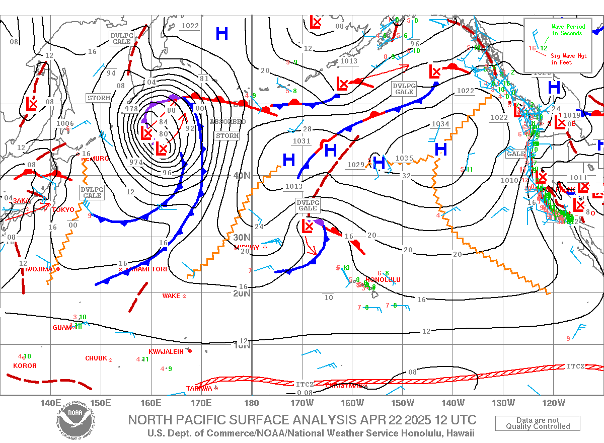
Clarified that, let's have a look at today's weather map that shows two beautiful lows. I call this the sad clown face map and it's my favorite. The two lows are the eyes and the mouth is a high that hopefully (like in this case) is not too open. When the high is bigger, the clown would be screaming and that's not a good sign, because a big high would block the development of the lows and increase the trade winds. So remember, sad clown better than screaming clown!
The low to the right was responsible for the NNW swell arriving today.
The one to the left will be responsible for a NW swell arriving later in the week.
Let's have a look at the Maui north shore forecast that I stole from Surfline (link n.15 on the right).
There's at least three pulses in the 12f range for Sunday, Wednesday, Thursday.
Oh, I'm off all those three days next week, but I'm never too excited about a 12f swell. I don't surf Jaws and waves so big reduce greatly the number of surfable spots on the north shore, which means you got to drive more.
Talking about which, I think I set a personal record two days ago. The distance in miles between the spot I surfed in the morning and the one I surfed in the afternoon was 58!
Can easily be beaten by surfing Koki beach in Hana and then Honolua... that would be 86.
Have fun in the sun everyone!
Thursday, December 04, 2014
12 4 14 morning call
Maui north shore (indicative of what's in the water on Maui's north shore)
10.2ft @ 13s from 356° (N)
West lanai Maui north shore (indicative of what's in the water on Maui's south shore)
2ft @ 14s from 298° (WNW)
Have fun in the sun everyone!
Wednesday, December 03, 2014
12 3 14 morning call
Maui north shore (indicative of what's in the water on Maui's north shore)
8.4ft @ 13s from 18° (NNE)
West lanai Maui north shore (indicative of what's in the water on Maui's south shore)
2.2ft @ 13s from 290° (WNW)
The buoy came up during the night as the surfline graph shows below.
And since the wind will be a late afternoon business, at least according to the 2pm map below, I might as well try to surf them all!

Have fun in the sun everyone!
Tuesday, December 02, 2014
12 2 14 morning call
I will probably have no internet at home for a few days, so I'm doing this post from my phone.
Here's what's at the maui buoy:
5.1ft @ 10s from 21° (NNE)
5.1ft @ 11s from 23° (NNE)
4.2ft @ 5s from 38° (NE)
3.7ft @ 15s from 324° (NW)
The apparently NW swell actually reads 6f 15s from 301 at the waimea and nw buoys and that shows you the refraction i was posting about yesterday.
The waves bend around all those islands and arrive on maui's north shore from a direction that is 23 degrees different, pretty much half the size and - this is not shown by the buoys - way less consistent.
The NNE swell will be far more consistent but, due to the difference in period, the nw sets will be easy to spot.
Photo from hookipa coming up soon.
Have fun in the sun everyone!
Monday, December 01, 2014
12 1 14 morning
NW
5.1ft @ 7s from 69° (ENE)
Waimea
6.2ft @ 8s from 14° (NNE)
Maui north shore (indicative of what's in the water on Maui's north shore)
West lanai Maui north shore (indicative of what's in the water on Maui's south shore)
Still 4.5f 12s from 12, this is a very long stretch of waves out of the north (which I love because they hit some of my favorite spots!) and it is not supposed to end anytime soon!
Actually today a WNW swell will also rise, but Maui will be heavily shadowed.
You can see 5f 18s from 281 at the NW buoy and 1f 22s from 310 at Waimea. Which might bring a question:"why is direction so different?"
The main reason is refraction, which I explain as: the waves bend around islands and land points.
So what we will get in the late afternoon (mostly Hookipa and east of it) is whatever evergy will manage to bend around (in the order):
-
- Kauai
- Oahu
- Molokai
As you can see, I circled the two fetches generating waves for us today. The one to the NW of the islands, is now not oriented towards us anymore, but will still make waves for us.
The big arrow I drew indicates the main direction of the swell. But waves have the amazing ability of spreading from that both "left" and "right", and I drew two thinner arrows to show that.
Clearly, the energy and specially the consistency of the swell is much higher in a spot that is hit straight by the core of the swell, rather than on the edge of its angular spreading.
Have fun in the sun everyone!