10.30am. Honolua is inconsistent chest high at the cave and waist high at the point. 14 guys at the cave
Friday, April 22, 2016


4 22 16 morning call
Surfed the same break in the morning and in the late afternoon and the tide made a huge difference.
Average at low tide, firing at a higher one. I've been told I never mention the tides. True. But there's not much to say about them in Hawaii, other than... what I'm about to say right now.
Tide swings here can go from a maximum of 3 feet to a minimum of zero (that's when it seems that there's only one low and one high in the day). As such, the difference in the behavior of the waves are not so extreme as in other places with bigger tide swings. As such, they're not as critical.
But they do make a difference in some places. Knowing the tide when you go surfing is a must. That's the only way to build that knowledge of what tide a particular spot likes (with a particular swell size, period and direction, I should add...).
The reason I never mention them is that you can check them yourself by clicking on link n.12. Links from 1 to 17 are the ones that I read every morning before making this call. That website is accurate and it's the only one I use. I also like it because it offers the tides also in different part of the island. For example, by clicking on Lahaina, you'll find out that today over there there's a full moon low tide at 9.24am. I scheduled my student for a 5.45am start, because I sure want to avoid that. And, I will be able to have my session after the lesson on the rising tide, which is usually regarded as a good moment for most breaks, since you can feel the "push of the tide".
I've never really believed much in it (at least in Maui) and for me what makes the difference is how much water there is on top of the reef where the waves break, more than if the tide is going out or coming in and at what speed. Yesterday's afternoon session, for example, was on a tide going from high to mid and it was just firing, as I said. And if could have stopped the flow of the tide with a button, I sure would have done it. Because it was evident that that size swell, with that period and from that direction, just loved that amount of water on top of that reef. As good as I've ever seen it, really.
Well, there you have it. That's what I think about tides, next time I'll mention them will probably be in a year or so.
This photo by Jimmie Hepp sums up the afternoon conditions at Hookipa: windy and wavy and the windsurfers keep scoring.

Significant buoy readings at 4am
NW
5.5ft @ 12s from 317° (NW)
2.7ft @ 10s from 336° (NNW)
N
5.4ft @ 14s from 298° (WNW)

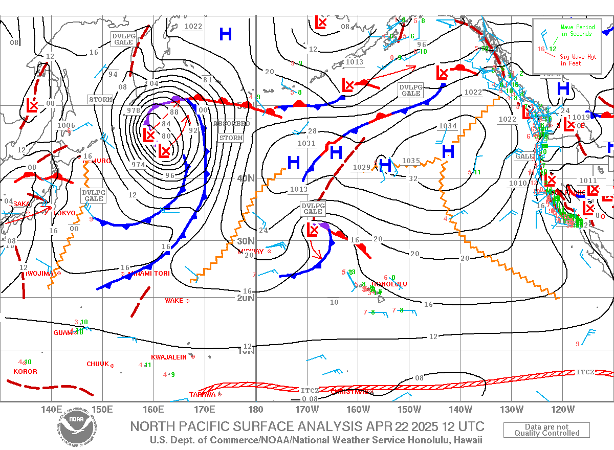
Wind map shows close to zero wave generation today. Monday/Tuesday is going to be pretty small. I leave Sunday night...

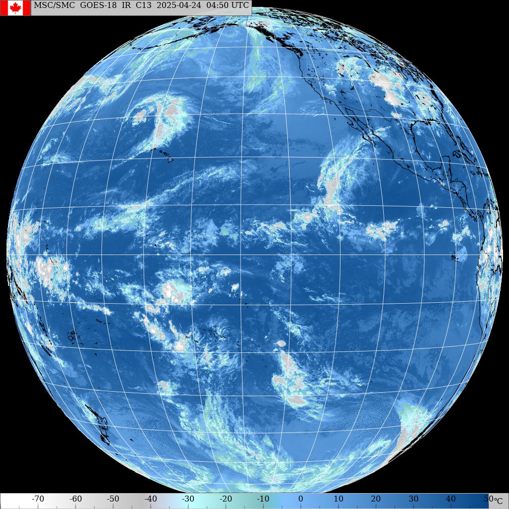
Not much going on south either, other than another Tasman sea swell (too bad I'm not going to Fiji) and a cyclone that might ruin the trip of some friends that left to Samoa yesterday.

Easterly wind, check the MC2km map whenever they will update it.
No time to review this call, sorry for typos, grammar and other mistakes.
Average at low tide, firing at a higher one. I've been told I never mention the tides. True. But there's not much to say about them in Hawaii, other than... what I'm about to say right now.
Tide swings here can go from a maximum of 3 feet to a minimum of zero (that's when it seems that there's only one low and one high in the day). As such, the difference in the behavior of the waves are not so extreme as in other places with bigger tide swings. As such, they're not as critical.
But they do make a difference in some places. Knowing the tide when you go surfing is a must. That's the only way to build that knowledge of what tide a particular spot likes (with a particular swell size, period and direction, I should add...).
The reason I never mention them is that you can check them yourself by clicking on link n.12. Links from 1 to 17 are the ones that I read every morning before making this call. That website is accurate and it's the only one I use. I also like it because it offers the tides also in different part of the island. For example, by clicking on Lahaina, you'll find out that today over there there's a full moon low tide at 9.24am. I scheduled my student for a 5.45am start, because I sure want to avoid that. And, I will be able to have my session after the lesson on the rising tide, which is usually regarded as a good moment for most breaks, since you can feel the "push of the tide".
I've never really believed much in it (at least in Maui) and for me what makes the difference is how much water there is on top of the reef where the waves break, more than if the tide is going out or coming in and at what speed. Yesterday's afternoon session, for example, was on a tide going from high to mid and it was just firing, as I said. And if could have stopped the flow of the tide with a button, I sure would have done it. Because it was evident that that size swell, with that period and from that direction, just loved that amount of water on top of that reef. As good as I've ever seen it, really.
Well, there you have it. That's what I think about tides, next time I'll mention them will probably be in a year or so.
This photo by Jimmie Hepp sums up the afternoon conditions at Hookipa: windy and wavy and the windsurfers keep scoring.

Significant buoy readings at 4am
NW
5.5ft @ 12s from 317° (NW)
2.7ft @ 10s from 336° (NNW)
N
5.4ft @ 14s from 298° (WNW)
4.1ft @ 10s from 311° (NW)
Waimea
4.9ft @ 13s from 321° (NW)
Waimea
4.9ft @ 13s from 321° (NW)
2.6ft @ 9s from 357° (N)
Barbers
2.8ft @ 14s from 264° (W)
Barbers
2.8ft @ 14s from 264° (W)
1.5ft @ 16s from 211° (SW)
A reinforcement was expected today for the current NW swell. Looking at the graph of the NW buoy on the left below, I can see a little bump back up, but not much really. Plus the period kept going down and that'll limit the sizes. In other words, I don't see the waves picking up some size at the buoys at all. BUT, look where the swell is coming now from at the NW buoy: 317. Now, THAT is going to make a difference. I put two red arrows to point out how much the swell changed its direction compared to two days ago. That's almost 20 degrees and that reflects the path that the storm (and the fetch) had when the swell was generated.
So I'm calling for similar sizes, more consistency, a little less power and a little less clean breaking pattern due to the 9-10s northerly component on top of the main swell.
Don't ask me why the North buoy always shows a much more westerly direction, 'cause I have no idea. It might be related to the fact that it's still adrift, like Pat Cadlwell mentioned months ago and that's why I tend to overlook it a bit.
Lastly but leastly, a quick comment on Barbers' readings. Both the two local (close to shore) buoys that are open to the south (Lanai and Barbers) are hit by the wrap of the NW energy eventually in the water. That's what that W reading is. Sometimes, like in the Lanai case this morning, this energy masks the energy of the south swells eventually in the water. Fortunately Barbers is sensitive enough to also reads 1.5ft @ 16s from 211° (SW) and that's an indication of the southerly energy we were expecting. Not the most exciting reading, but there were some sets already yesterday, so check the cam before going, as usual.
So I'm calling for similar sizes, more consistency, a little less power and a little less clean breaking pattern due to the 9-10s northerly component on top of the main swell.
Don't ask me why the North buoy always shows a much more westerly direction, 'cause I have no idea. It might be related to the fact that it's still adrift, like Pat Cadlwell mentioned months ago and that's why I tend to overlook it a bit.
Lastly but leastly, a quick comment on Barbers' readings. Both the two local (close to shore) buoys that are open to the south (Lanai and Barbers) are hit by the wrap of the NW energy eventually in the water. That's what that W reading is. Sometimes, like in the Lanai case this morning, this energy masks the energy of the south swells eventually in the water. Fortunately Barbers is sensitive enough to also reads 1.5ft @ 16s from 211° (SW) and that's an indication of the southerly energy we were expecting. Not the most exciting reading, but there were some sets already yesterday, so check the cam before going, as usual.

Wind map shows close to zero wave generation today. Monday/Tuesday is going to be pretty small. I leave Sunday night...

Not much going on south either, other than another Tasman sea swell (too bad I'm not going to Fiji) and a cyclone that might ruin the trip of some friends that left to Samoa yesterday.

Easterly wind, check the MC2km map whenever they will update it.
No time to review this call, sorry for typos, grammar and other mistakes.
Thursday, April 21, 2016
4 21 16 morning call
As I wrote in the more and more frequent updates (keep checking the blog during the day and you might score a session one of these days), yesterday I didn't like the morning conditions on the north shore and I took advantage of a day off to go check the bay.
This has been a bit the year of the bay for me. Not that I surfed it all that much, but 10-15 sessions is a lot more than the annual 3-4 I used to do over there. I also surfed the Point at Hookipa more, that helped the confidence in the back hand take offs, I guess. It was about time.
Wasn't worth the $6 drive (on the highway I can easily pull 30 mpg), if you look at half empty part of the glass. Long waits in between sets and lots of people paddling when it finally came. No bad energy in the water, just more people than waves.
BUT.
- I totally enjoyed the beautiful drive, despite the fact it I must have done it hundreds of times
- I learned what a long period swell from originally 300 degrees does at the bay
- I caught a few
- I had a bunch of lovely chats in the lineup both with locals and visitors
- I figured a way of climbing back up the path without putting too much load on my weak left knee
That's more than a half full glass, that's three quarters full!
After the session I shot one wave as surf reporters oughta do.

And after sipping a lovely Maui Home Grown coffee (in Lahaina at the corner of the main highway and Lahainaluna, mountain side next to the gas station) during my drive back (for which purpose the American coffee sacrilegiously beats hands down the Italian espresso), I got to Hookipa and shot the pros do their thing in very challenging/bumpy conditions.
The best two shots go to an in form Robby Swift.


Second surf session was at neighborhood break that was looking like a good 8.5 out of 10. I had a couple of very fun rides when... 3 o'clock came and the groms showed up.
I did good with the first four. We're talking some of the top Maui groms, kids like Jackson Bunch and the three Robberson's, for the youngest of which it was often double overhead.
One of those situations in which if you miss a wave, you're done. They're never going to expect you to catch one anymore. Not even in the next sessions, 'cause they'll remember you. You're kind of marked "kook" for life, unless you redeem yourself by sticking a free fall drop into the barrel while they're paddling out in the channel and they see you.
But I caught all my waves and was getting immediate respect. I also thoroughly enjoyed watching those kids rip and their contagious frothy energy. They yell "GO, GO" at each other, each single wave that comes. I never heard one of them say:"nah, I think you're too deep, let it go...".
I confess I used to be intimidated by a bunch of young rippers, but now I only get inspired.
The spectacle became even better when Axel Rosenblad and 5 more paddled out. So much to learn, those kids are so quick on their legs.
That was it for my session though. I could handle 4, not 10. I happily left them the lineup hoping that the first four kids will remember that uncle can paddle...
Lil' bbq with friends at the beach and now this post to refresh the memories of a really good day.
Just another one. Tomorrow is another day and another call will be made at the appropriate time.
-------------------------------------------------------
And the appropriate time came in the form of 5.15am and here's your call.
5am significan buoy readings
NW
6ft @ 14s from 301° (WNW)
N
6.2ft @ 15s from 289° (WNW)
Waimea
6.6ft @ 15s from 322° (NW)
Lanai
2.9ft @ 15s from 284° (WNW)
WNW swells staying pretty steady both in size and direction, today we can expect similar size compared to yesterday.

Wind map shows trades with a direction that is finally going a bit more offshore (look at direction away from the coast). Been too onshore and bumpy lately for me to get motivated to go windsurfing.
I'm a very picky windsurfer: unless it's really good, I'd rather go surf.

Wind map shows a nicely oriented by weak fetch. I'm guessing Hookipa will get head high 12 seconds out of that one around Sunday.

South pacific shows a fetch oriented a bit too east, but we'll get some angular spreading out of it.

Cloudbreak went off a few days ago (Surfline features great shots here.) and you would think we're gonna get some of that energy at one point.
Below is the weather map of April 10th in both the classic version with the isobars and the Windity graphical representation. Tasman sea fetches don't do too much for us, unless they're oriented in a perfect magic way that I have no idea what is. But Surfline has something in the forecast and even though I didn't see anything of relevance at the Samoa buoy (swell might have missed it to the west, but could still get to us), we'll wait and see what happens.


The good news is that the same storm moved east and set up a nicely oriented, un-obstructed fetch 4 days later on the 14th. Related maps are below and that's when you can kind of count on a south swell. The fetch needs to be east of New Zealand, strong, long, wide and the more straight north to south, the better.


This one wasn't all that great both in terms of orientation and intensity IMO, and that is reflected by the average reading this morning at the Samoa buoy: 2.9ft @ 16s from 194° (SSW). The first 20s readings started Wednesday morning. Samoa is 2272 nm from Maui, 20s travel at 30 knots, that makes it 3 days to get here (3.5 days for 16s), which means Saturday morning. All is confirmed by the Surfline forecast below. Swell 1 is the Fiji one coming out of the Tasman sea, west of New Zealand. Swell 2 is the one coming out of the east of New Zealand.
Chech the Lahaina webcam, because, in line with the forecast, I've seen some sets already this morning. No related readings at the Lanai buoy, because they're masked by the WNW wrap.

This has been a bit the year of the bay for me. Not that I surfed it all that much, but 10-15 sessions is a lot more than the annual 3-4 I used to do over there. I also surfed the Point at Hookipa more, that helped the confidence in the back hand take offs, I guess. It was about time.
Wasn't worth the $6 drive (on the highway I can easily pull 30 mpg), if you look at half empty part of the glass. Long waits in between sets and lots of people paddling when it finally came. No bad energy in the water, just more people than waves.
BUT.
- I totally enjoyed the beautiful drive, despite the fact it I must have done it hundreds of times
- I learned what a long period swell from originally 300 degrees does at the bay
- I caught a few
- I had a bunch of lovely chats in the lineup both with locals and visitors
- I figured a way of climbing back up the path without putting too much load on my weak left knee
That's more than a half full glass, that's three quarters full!
After the session I shot one wave as surf reporters oughta do.

And after sipping a lovely Maui Home Grown coffee (in Lahaina at the corner of the main highway and Lahainaluna, mountain side next to the gas station) during my drive back (for which purpose the American coffee sacrilegiously beats hands down the Italian espresso), I got to Hookipa and shot the pros do their thing in very challenging/bumpy conditions.
The best two shots go to an in form Robby Swift.


Second surf session was at neighborhood break that was looking like a good 8.5 out of 10. I had a couple of very fun rides when... 3 o'clock came and the groms showed up.
I did good with the first four. We're talking some of the top Maui groms, kids like Jackson Bunch and the three Robberson's, for the youngest of which it was often double overhead.
One of those situations in which if you miss a wave, you're done. They're never going to expect you to catch one anymore. Not even in the next sessions, 'cause they'll remember you. You're kind of marked "kook" for life, unless you redeem yourself by sticking a free fall drop into the barrel while they're paddling out in the channel and they see you.
But I caught all my waves and was getting immediate respect. I also thoroughly enjoyed watching those kids rip and their contagious frothy energy. They yell "GO, GO" at each other, each single wave that comes. I never heard one of them say:"nah, I think you're too deep, let it go...".
I confess I used to be intimidated by a bunch of young rippers, but now I only get inspired.
The spectacle became even better when Axel Rosenblad and 5 more paddled out. So much to learn, those kids are so quick on their legs.
That was it for my session though. I could handle 4, not 10. I happily left them the lineup hoping that the first four kids will remember that uncle can paddle...
Lil' bbq with friends at the beach and now this post to refresh the memories of a really good day.
Just another one. Tomorrow is another day and another call will be made at the appropriate time.
-------------------------------------------------------
And the appropriate time came in the form of 5.15am and here's your call.
5am significan buoy readings
NW
6ft @ 14s from 301° (WNW)
N
6.2ft @ 15s from 289° (WNW)
Waimea
6.6ft @ 15s from 322° (NW)
Lanai
2.9ft @ 15s from 284° (WNW)
WNW swells staying pretty steady both in size and direction, today we can expect similar size compared to yesterday.

Wind map shows trades with a direction that is finally going a bit more offshore (look at direction away from the coast). Been too onshore and bumpy lately for me to get motivated to go windsurfing.
I'm a very picky windsurfer: unless it's really good, I'd rather go surf.

Wind map shows a nicely oriented by weak fetch. I'm guessing Hookipa will get head high 12 seconds out of that one around Sunday.

South pacific shows a fetch oriented a bit too east, but we'll get some angular spreading out of it.

Cloudbreak went off a few days ago (Surfline features great shots here.) and you would think we're gonna get some of that energy at one point.
Below is the weather map of April 10th in both the classic version with the isobars and the Windity graphical representation. Tasman sea fetches don't do too much for us, unless they're oriented in a perfect magic way that I have no idea what is. But Surfline has something in the forecast and even though I didn't see anything of relevance at the Samoa buoy (swell might have missed it to the west, but could still get to us), we'll wait and see what happens.


The good news is that the same storm moved east and set up a nicely oriented, un-obstructed fetch 4 days later on the 14th. Related maps are below and that's when you can kind of count on a south swell. The fetch needs to be east of New Zealand, strong, long, wide and the more straight north to south, the better.


This one wasn't all that great both in terms of orientation and intensity IMO, and that is reflected by the average reading this morning at the Samoa buoy: 2.9ft @ 16s from 194° (SSW). The first 20s readings started Wednesday morning. Samoa is 2272 nm from Maui, 20s travel at 30 knots, that makes it 3 days to get here (3.5 days for 16s), which means Saturday morning. All is confirmed by the Surfline forecast below. Swell 1 is the Fiji one coming out of the Tasman sea, west of New Zealand. Swell 2 is the one coming out of the east of New Zealand.
Chech the Lahaina webcam, because, in line with the forecast, I've seen some sets already this morning. No related readings at the Lanai buoy, because they're masked by the WNW wrap.

Wednesday, April 20, 2016

4 20 16 morning call
The action shots from yesterday were already posted in the 8.30am update, so scroll down if you want to see the wave size in the morning. At sunset it looked a bit bigger, but definitely not due to the fore runners of the WNW swell. It was cloudy, onshore and cold, but there were some clean faces.
Significant buoy readings 5am
NW
7.6ft @ 16s from 301° (WNW)
Waimea
5.3ft @ 17s from 312° (NW)
Significant buoy readings 5am
NW
7.6ft @ 16s from 301° (WNW)
Waimea
5.3ft @ 17s from 312° (NW)
4.1ft @ 7s from 23° (NNE)
N
5.3ft @ 17s from 289° (WNW)
4.4ft @ 8s from 47° (NE)
3.4ft @ 12s from 71° (ENE)
Lanai
1.8ft @ 18s from 294° (WNW)


1.4ft @ 13s from 191° (SSW)
The NW and Waimea graphs are below. Last readings are 5am, don't be fooled by the wrong placement on the time line.
300 degrees is not a good direction for Maui. The only place with significant wave size will be Hookipa, even though I did see a couple of sets on the webcam at Kanaha. The wind is on it already.
Surfline forecasts the swell to pick up a couple of feet during the day and peak at 8pm at 7.5f 15s from 315 (that's after the refraction on the upstream islands).
Surfline forecasts the swell to pick up a couple of feet during the day and peak at 8pm at 7.5f 15s from 315 (that's after the refraction on the upstream islands).

I was hoping the swell would be west enough to hit the Kihei coast, but judging from the shore break (or lack of there of) in the bottom cam, I don't think there's much down there. I was also hoping that those 1.4f 13s from 191 at the Lanai buoy would do something a little bigger than what the webcam in Lahaina shows (top right).
I guess I'll stay on the windy north shore.
I guess I'll stay on the windy north shore.

MC2km map at noon shows the wind that it shows.


Wind map shows that yesterday's good NW fetch has already moved east a lot and is now aiming at the mainland west coast and not doing much for us anymore. Nonetheless, yesterday's wave generation will send a reinforcement to the current swell on Friday.
A few days ago I said that there's not gonna be much on the north shore after I leave on Sunday. I take that back. The models changed and now there's a bunch of fun size NW swells lined up every other 3-4 days.
A few days ago I said that there's not gonna be much on the north shore after I leave on Sunday. I take that back. The models changed and now there's a bunch of fun size NW swells lined up every other 3-4 days.

South shore will have some action too starting this Friday. Today's a good fetch (mark your calendar in a week), but tomorrow should be aiming elsewhere already.

Subscribe to:
Posts (Atom)