8am yes, there are inconsistent bigger sets in town, up to head high
Tuesday, April 23, 2019


4 23 19 morning call
The funding campaign for the new Lahaina harbor webcam has raised $2025. The goal is reached and we should have the webcam online any time soon.
A day of rest for me yesterday. Jimmie Hepp went to Hookipa and shot the windsurfers jumping on the small ramps. I picked this one out of this gallery.

4am significant buoy readings
South shore
SW
3ft @ 13s from 157° (SSE)
SE
2.5ft @ 14s from 182° (S)
Barbers
1.8ft @ 15s from 186° (S)
Lanai
1.8ft @ 14s from 183° (S)
South swell finally showing at all the buoys, I'll report before 7am.
North shore
Hanalei
1.4ft @ 15s from 308° (WNW)
Waimea
0.9ft @ 11s from 313° (NW)
Pauwela
5.4ft @ 9s from 89° (E)
Confusing readings at the NW buoys (didn't even feel like reporting them), shall we trust Hanalei and conclude that there will be a small bump on the way for today?
Let's see what Pat Caldwell says:
The strength of the low pressure systems in the north Pacific became much weaker last week relative to the active pattern of late March into early April. These weak low pressure systems have been steered east by a zonal jet, which also reduces surf potential by limiting fetch duration. This is expected to give spring minimal conditions this week.
A weak low tracked rapidly NE from 35N, 165E 4/19 to the Gulf of Alaska 4/22. Top surface winds speeds aimed at Hawaii were sub- gale. Short-period energy is predicted to bring tiny to small breakers from 305-320 degrees Tuesday, peak on Wednesday from 315-340 degrees, then drop on Thursday from 340-360 degrees.
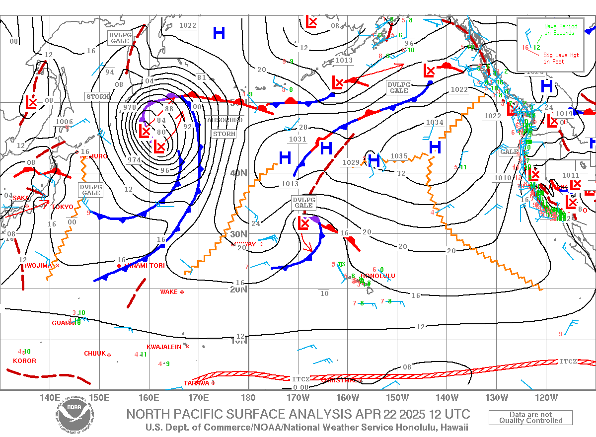
Below is the collage of the maps of April 20, 21 and 22. You can see how quickly that small low raced across the great circle rays towards the Gulf of Alaska. So maybe a small bump in the afternoon, but it'll still be mostly windswell, imo.

Wind map at noon.

North Pacific only has the windswell fetch.

South Pacific has an intense but tiny and buried deep south of the Tasman Sea fetch. Overall another pretty poor day of wave generation for Hawaii.

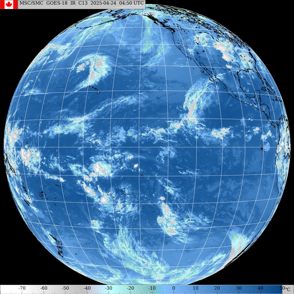
Morning sky.

A day of rest for me yesterday. Jimmie Hepp went to Hookipa and shot the windsurfers jumping on the small ramps. I picked this one out of this gallery.

4am significant buoy readings
South shore
SW
3ft @ 13s from 157° (SSE)
SE
2.5ft @ 14s from 182° (S)
Barbers
1.8ft @ 15s from 186° (S)
1.7ft @ 13s from 183° (S)
Lanai
1.8ft @ 14s from 183° (S)
South swell finally showing at all the buoys, I'll report before 7am.
North shore
Hanalei
1.4ft @ 15s from 308° (WNW)
Waimea
0.9ft @ 11s from 313° (NW)
Pauwela
5.4ft @ 9s from 89° (E)
4ft @ 6s from 76° (ENE)
Confusing readings at the NW buoys (didn't even feel like reporting them), shall we trust Hanalei and conclude that there will be a small bump on the way for today?
Let's see what Pat Caldwell says:
The strength of the low pressure systems in the north Pacific became much weaker last week relative to the active pattern of late March into early April. These weak low pressure systems have been steered east by a zonal jet, which also reduces surf potential by limiting fetch duration. This is expected to give spring minimal conditions this week.
A weak low tracked rapidly NE from 35N, 165E 4/19 to the Gulf of Alaska 4/22. Top surface winds speeds aimed at Hawaii were sub- gale. Short-period energy is predicted to bring tiny to small breakers from 305-320 degrees Tuesday, peak on Wednesday from 315-340 degrees, then drop on Thursday from 340-360 degrees.
Below is the collage of the maps of April 20, 21 and 22. You can see how quickly that small low raced across the great circle rays towards the Gulf of Alaska. So maybe a small bump in the afternoon, but it'll still be mostly windswell, imo.

Wind map at noon.

North Pacific only has the windswell fetch.

South Pacific has an intense but tiny and buried deep south of the Tasman Sea fetch. Overall another pretty poor day of wave generation for Hawaii.

Morning sky.

Monday, April 22, 2019
Monday 4 22 19 morning call
The funding campaign for the new Lahaina harbor webcam has raised $1685. Thanks a lot and let's keep them coming. I'm gonna start my posts with an update like this until it reaches its goal of $2,000. Please donate to the page, not to me. I have nothing to do with this campaign, other than the fact that I totally support the cause.
A SUP surfing session for me yesterday. I wanted to test a device I bought that allows me to paddle without stressing the trigger fingers. Worked pretty good, will document after I test it a bit more. In the meantime, Here's Kai Lenny doing what he does. My comment to this was: "Unimaginable. Until Kai does it!".

5am significant buoy readings
Barbers
1.5ft @ 13s from 193° (SSW)


North shore
Pauwela


A SUP surfing session for me yesterday. I wanted to test a device I bought that allows me to paddle without stressing the trigger fingers. Worked pretty good, will document after I test it a bit more. In the meantime, Here's Kai Lenny doing what he does. My comment to this was: "Unimaginable. Until Kai does it!".

5am significant buoy readings
Barbers
1.5ft @ 13s from 193° (SSW)
1.1ft @ 16s from 190° (S)
Lanai
1ft @ 13s from 179° (S)
Yesterday Thousand Peaks was knee to occasionally waist high late morning on the rising tide. Today it should be a similar day maybe with a smaller start due to the low tide. Below are Waikiki and Kihei and the difference in energy is remarkable, but not surprising if you look at the maps. Yes, Oahu gets better waves also in summer, not only in winter.

Wait, weren't be supposed to get a south swell this week? Yes we were! Below is the collage of the fetch maps of April 15, 16, 17 and 18 and they all look pretty decent. And so, where did it go? It might be that it's taking its time, since the fetches were wide, but the winds weren't particularly strong in them and so they only created medium periods that travel slower than long periods. Or it might be for some other reasons. I think tomorrow we should see an increase, but don't forget the number one rule for south swells: never, ever, under any circumstances get excited for an upcoming south swell in Maui.

North shore
Pauwela
4.8ft @ 8s from 89° (E)
That's it, 5ft 8s from the E is all there is in the water. Hookipa will be close to flat, while the east facing shores will be maybe up to chest high.
Wind map at noon.

North Pacific only has the windswell fetch.

South Pacific has a big and strong fetch oriented towards Central America. Catch a plane to fly there or hope in the angular spreading!

Morning sky.

Sunday, April 21, 2019
Sunday 4 21 19 morning call
The funding campaign for the new Lahaina harbor webcam has raised $1685. Thanks a lot and let's keep them coming. I'm gonna start my posts with an update like this until it reaches its goal of $2,000. Please donate to the page, not to me. I have nothing to do with this campaign, other than the fact that I totally support the cause.
A shortboard session for me yesterday. This is my pick of Jimmie Hepp's daily gallery of the windsurfing action at Hookipa. It was mostly windswell and it will be only windswell today.

6am significant buoy readings
South shore
Barbers
1.5ft @ 14s from 203° (SSW)
Lanai
1ft @ 13s from 187° (S)
Background energy still in the water while Barbers feels a sliver of 18s which could mean that tomorrow we should have the expected little swell that was in the forecast. Just by looking at the Kihei cam, flat to knee is my call for today.
Below is an image from the Kapiolani Park webcam, which I also added to the list. It shows line long period very small lines, but don't forget that Oahu gets a lot more energy than Maui, as they don't have Kahoolawe right in front blocking part of it.

North shore
Pauwela
6.7ft @ 8s from 87° (E)
We're now down to windswell only and it's also pretty easterly, so only a portion of it will make it to Hookipa, which should be less than head high.
Wind map at noon.

North shore has several scattered fetches.

Nothing form the south.

Morning sky.

A shortboard session for me yesterday. This is my pick of Jimmie Hepp's daily gallery of the windsurfing action at Hookipa. It was mostly windswell and it will be only windswell today.

6am significant buoy readings
South shore
Barbers
1.5ft @ 14s from 203° (SSW)
0.3ft @ 18s from 204° (SSW)
Lanai
Background energy still in the water while Barbers feels a sliver of 18s which could mean that tomorrow we should have the expected little swell that was in the forecast. Just by looking at the Kihei cam, flat to knee is my call for today.
Below is an image from the Kapiolani Park webcam, which I also added to the list. It shows line long period very small lines, but don't forget that Oahu gets a lot more energy than Maui, as they don't have Kahoolawe right in front blocking part of it.

North shore
Pauwela
6.7ft @ 8s from 87° (E)
We're now down to windswell only and it's also pretty easterly, so only a portion of it will make it to Hookipa, which should be less than head high.
Wind map at noon.

North shore has several scattered fetches.

Nothing form the south.

Morning sky.

Saturday, April 20, 2019
Saturday 4 20 19 morning call
The funding campaign for the new Lahaina harbor webcam has raised $1685. Thanks a lot and let's keep them coming. I'm gonna start my posts with an update like this until it reaches its goal of $2,000. Please donate to the page, not to me. I have nothing to do with this campaign, other than the fact that I totally support the cause.
Three shortboard and one longboard session for me yesterday. I was off and I knew this was going to be one of the last days of good waves, so I milked it till my arms dropped. This is how Honolua looked when I arrived after my first Hookipa session: head high and building. I hit the water right away.

In the afternoon the swell built up to an extremely fun head and a half size.

Most likely, he's going to have to wait until next winter for a vision like that. Once again, you never know. There'll be plenty more swells on the north shore of course, but you guys know how picky the Bay is with direction, size, period and everything else.

Let's now jump to Jimmie Hepp's windsurfing shots. He was celebrating 10 years of shooting Hookipa. On this blog I've been posting photos of it (and everything else) since 2005 and when Jimmie came along I was very relieved: finally someone else was posting shots on a "free" site (Facebook) and with a much better camera, so that I didn't have to do it! Thank you Jimmie for your hard work.
This is my wave-based pick of his gallery of the day.

Today I also had to pick one based on the move. Guadalupe's Antoine Martin is the most entertaining windsurfer in the world in my opinion. His skills are mad and he's mad too! This is a backloop off the lip (which means he's riding the wave, hitting the lip and throwing a backloop in front of it. A maneuver of a degree of difficulty I can't even grasp. You land one like this in a contest, it's an automatic 10.

Back to my sessions, here's a couple of gropro shots on two different super duper "secret" lefts. Good luck with the guessing!


4am significant buoy readings
South shore
Barbers
1.5ft @ 14s from 202° (SSW)
Lanai
1.5ft @ 13s from 229° (SW)
Background energy still there. Yesterday the Lahaina side was tiny (but not flat) and judging from what I see at the Kihei webcam, this is going to be the case also today. Very soon the Lahaina cam will be online, please keep the donations coming.
North shore
NW101
2.3ft @ 11s from 344° (NNW)
Hanalei
2.4ft @ 11s from 345° (NNW)
Waimea
2ft @ 11s from 331° (NNW)
Pauwela
5.3ft @ 8s from 80° (E)

Wind map at noon.

North Pacific only has a weak windswell fetch.

Nothing of relevance from the south either, pretty horrible day of wave generation for Hawaii. That's totally normal, in the transition seasons (fall and spring) you can have both sides of the Pacific firing or both of them dormant.

Morning sky.

Three shortboard and one longboard session for me yesterday. I was off and I knew this was going to be one of the last days of good waves, so I milked it till my arms dropped. This is how Honolua looked when I arrived after my first Hookipa session: head high and building. I hit the water right away.

In the afternoon the swell built up to an extremely fun head and a half size.

Most likely, he's going to have to wait until next winter for a vision like that. Once again, you never know. There'll be plenty more swells on the north shore of course, but you guys know how picky the Bay is with direction, size, period and everything else.

Let's now jump to Jimmie Hepp's windsurfing shots. He was celebrating 10 years of shooting Hookipa. On this blog I've been posting photos of it (and everything else) since 2005 and when Jimmie came along I was very relieved: finally someone else was posting shots on a "free" site (Facebook) and with a much better camera, so that I didn't have to do it! Thank you Jimmie for your hard work.
This is my wave-based pick of his gallery of the day.

Today I also had to pick one based on the move. Guadalupe's Antoine Martin is the most entertaining windsurfer in the world in my opinion. His skills are mad and he's mad too! This is a backloop off the lip (which means he's riding the wave, hitting the lip and throwing a backloop in front of it. A maneuver of a degree of difficulty I can't even grasp. You land one like this in a contest, it's an automatic 10.

Back to my sessions, here's a couple of gropro shots on two different super duper "secret" lefts. Good luck with the guessing!


4am significant buoy readings
South shore
Barbers
1.5ft @ 14s from 202° (SSW)
Lanai
1.5ft @ 13s from 229° (SW)
Background energy still there. Yesterday the Lahaina side was tiny (but not flat) and judging from what I see at the Kihei webcam, this is going to be the case also today. Very soon the Lahaina cam will be online, please keep the donations coming.
North shore
NW101
2.3ft @ 11s from 344° (NNW)
2.1ft @ 10s from 336° (NNW)
Hanalei
2.4ft @ 11s from 345° (NNW)
Waimea
2ft @ 11s from 331° (NNW)
Pauwela
5.3ft @ 8s from 80° (E)
3.9ft @ 11s from 332° (NNW)
Below is the graph of Pauwela together with yesterday's Surfline forecast. You can see how the swell peaked earlier than the forecast, so today we can expect much smaller size than yesterday afternoon and declining. That is also confirmed by the readings of all the upstream buoys. Make good use if it, because after that it's going to me mostly windswell (with some possible low NW energy here and there) for at least a couple of weeks.

Wind map at noon.

North Pacific only has a weak windswell fetch.

Nothing of relevance from the south either, pretty horrible day of wave generation for Hawaii. That's totally normal, in the transition seasons (fall and spring) you can have both sides of the Pacific firing or both of them dormant.

Morning sky.

Friday, April 19, 2019
Friday 4 19 19 morning call
The funding campaign for the new Lahaina harbor webcam has raised $1685. Thanks a lot and let's keep them coming. I'm gonna start my posts with an update like this until it reaches its goal of $2,000. Please donate to the page, not to me. I have nothing to do with this campaign, other than the fact that I totally support the cause.
A longboard session for me yesterday. This is my pick of Jimmie Hepp's daily gallery of the windsurfing action at Hookipa. That wave is well above the average of the day.

4am significant buoy readings
South shore
Barbers
1ft @ 14s from 229° (SW)
Lanai
1ft @ 14s from 188° (S)
Background energy still at the local south facing buoys. Kihei cam doesn't show much, so I'm going to call the usual flat to knee high.
North shore
NW101
6ft @ 12s from 336° (NNW)
Hanalei
4.6ft @ 13s from 337° (NNW)
Waimea
2.1ft @ 14s from 325° (NW)
Pauwela
4.9ft @ 8s from 62° (ENE)

Tiny WNW fetch in the North Pacific.

South Pacific has a massive fetch oriented towards Central America, hopefully we'll get some angular spreading.

Morning sky.

A longboard session for me yesterday. This is my pick of Jimmie Hepp's daily gallery of the windsurfing action at Hookipa. That wave is well above the average of the day.

4am significant buoy readings
South shore
Barbers
1ft @ 14s from 229° (SW)
Lanai
1ft @ 14s from 188° (S)
Background energy still at the local south facing buoys. Kihei cam doesn't show much, so I'm going to call the usual flat to knee high.
North shore
NW101
6ft @ 12s from 336° (NNW)
Hanalei
4.6ft @ 13s from 337° (NNW)
Waimea
2.1ft @ 14s from 325° (NW)
Pauwela
4.9ft @ 8s from 62° (ENE)
1.7ft @ 5s from 79° (ENE)
1.4ft @ 14s from 349° (NNW)
1.2ft @ 12s from 343° (NNW)
New NNW swell on the rise all day. Below is the collage of the graphs of the reported buoys plus the Surfline forecast. The red line indicates the peak at the NW buoy, which happened around 8pm. At 12s, it takes 20h to get here, so we can expect this swell to peak right at sunset, which is pretty much also what the Surfline forecast shows. Early morning will still be pretty small and the very low tide at 8.25am won't help, but it will still be bigger than yesterday, probably with head high sets. I might post a Hookipa beach report before 7am. Quite possibly, this is the last opportunity of the season to surf Honolua, but you never know.

Wind map at noon.

Wind map at noon.

Tiny WNW fetch in the North Pacific.

South Pacific has a massive fetch oriented towards Central America, hopefully we'll get some angular spreading.

Morning sky.

Subscribe to:
Posts (Atom)