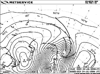
All those lines SE of New Zealand so close to each other mean gale force winds. This kind of sea level pressure configuration is there pretty much since last thursday and it will stay there for quite a few more days.
This means big swells on the south shore of the Hawaiian islands starting Thursday July 27th and lasting 7 to 10 days.
Monday it's going to be reeeally big.
Here's my surfing strategy for the event: I'll surf moderately at the beginning and in the weekend. Then, when everybody else will be surfed out, I'll hit it hard... trying not to be hit hard!
That's the plan. But I do fear that I'll forget about it and surf my ass off right away and be surfed out myself by Monday. In this case, I'll have plenty of time to take photos/videos. The remnants of hurricane Daniel will increase the trade winds on Friday up to 40 knots. And for those brave surfers out at Maalaea it's going to be tube time.
Maybe I will squeeze in a wavesailing session in Kihei.
Stay tuned.
PS I feel like a girl wondering what dress to wear at an upcoming wedding...
I got plenty boards, but I feel I need a good 9.0 for this swell... I may need to do some surfboard shopping... wuh-uh!


No comments:
Post a Comment