Just updated this post again with Pat Caldwell's contribution at the very bottom. Thanks a lot!
-----------------------------------------------------------------------
Just did a meteo appendix to the very end of this post. Stay tuned for uncle Pat's reply.
-----------------------------------------------------------------------
Goodness, what a swell episode we just had in Maui...

Let's start with Thursday.
The early morning NW buoy readings were around 10-12 feet and 10 seconds from ENE.
I drove Waiehu side and even though it definitely looked kinda big from the beach, I thought I could have fun in those big windswell chops. Usually in fact, the short period gives a character of mushyness to the waves.
Well it didn't take me long to find out that the reality was quite different out there.
I just couldn't believe how much those waves were shoaling upon meeting the reef. Something that looked like head high, grow to double overhead + in the last thirty yards right in front of me... I have no problem to admit that I got scared a couple of times.
The big sets were sucking the water out Teahupoo-like, like I have never seen in that spot that is mainly hit by windswells. I just couldn't believe that 10 seconds period waves could do that.
Anyway, I managed to survive a couple of washing machine treatments (thank god my leash didn't snap) and even caught a couple of fun insiders.
Later that day, I re-checked the buoys and noticed that the swell went up to what you now can see in the graph: an astonishing 22 feet and 15 seconds!!!!!
And that's the NW buoy that, given the ENE direction, is hit a few hours AFTER Maui.
Kinel, I was in the middle of a giant swell trying to catch waves on my trusty 6.10, while they were towing in at the next break at Paukaukalo...

Let's now see, thanks to the photos sent by different blog readers, what was happening elsewhere.
Early morning, a friend of mine, spotted Robby Naish, Dave Kalama and someone else entering the water at Hookipa with their standup.
A different friend, visitor Rick from Australia took a few photos. It looks like Lanes and most of the times it looks like Michi Schweiger to me.


This one on the phone is definitely Robby: "What? The harbor is going off? We'll be there in a jiffy!"

Here he is (or is it Michi again?) dropping in a bomb and Kai Lenny trying to catch it on the shoulder.


How's the spray on the last one? (click on it to see better). These photos were taken by Alex.
Meanwhile, Norwegian blog reader Tormod (check his
blog, he's got some cool photos of the lightning storm that happened Thursday night) took some photos of tow-in surfers at Honolua Bay.


Now, I've never done tow-in surfing (and probably never will, since I don't like jet skis... unless they're used for rescues, of course) and I shouldn't speak... but, as usual, I will nonetheless.
Look at the last photo. If that was Kelly Slater or any other good surfer, probably also the guy in the photo on a regular board, he would have a wider stance. Regular (good) surfers adjust their feet on the board almost at every turn. Having your feet stuck in fixed position footstraps must feel like an incredibly limiting sensation.
Bigger waves moves faster and if it's choppy straps are the only option, I guess. But on that wave in the photo, I bet the guy would have preferred to tow-in on a strapless board... but what do I know?
Let's move on to Friday.
The swell turned even more east and some veeery offshore and gusty trade winds kicked in.
Most of the reefs on the north shore of Maui were acting like huge right hand point breaks. Plenty people on the rocks at Hookipa, Lanes was mast and a half and so on.
BTW, I'm officially giving up with the Hookipa Rockstar Contest. Too difficult to keep track of the rockstars... Thanks to the sponsors that stepped in to support this idea, but it's a no go.
Where were we? Oh yeah, Friday afternoon wavesailing session.
I first rigged a 4.5, but the gusts were so strong that shortly I came back in to rig a 4.0. Like often happens, immediately after I went back out, the wind dropped and I sailed most session way underpowered. Which is a feeling that I usually like, but not with this size waves... check the first photo on the very top: that's me going out without much power in the sail...
And this is me again sailing out. Congratulations to Rick for taking such a beautiful shot with a no additional lens point and shoot camera.

This one is Pascal. Unfortunately it's the only photo Rick took of him, but I feel like mentioning how impressive his sailing was. I saw him on a couple of perfect mast high peelers doing three turns in the pocket and a final aerial.
"Yeah, I had a couple of good ones", he humbly commented...

This is Art, who sailed pretty damn good too.

This is the blog author who, instead, didn't sail good at all and was often off timing.
I'm going to blame the too small sail that didn't help to push the front of the rail down in the bottom turn (it was the first time ever in which I wished I had a heavier sail!) and the unusual direction of the waves and wind that made the waves behave differently. But that's exactly when the good sailors step up.
Live and learn...

At one point I lost my board and started a long swim. After a few minutes I saw a board far downwind. It was upside down and I had a clear glimpse of a black single fin, while mine was a twin fin.
"Whatever" I thought, "I'll swim for it anyway... I'll take any board at this point!!"
It was the board of this nice guy who was also holding mine. Thanks a lot and... what a wave!

French guy.

French guy aerial.

Well, thanks again to all the contributing photographers. I didn't have the time to take a single photo (too busy working, surfing and sailing)... it's great to have friends that take photos for you. And it's great to put them on a blog to share them with the rest of the world.
Internet rocks!
PS. Something remarkable just happened. After many years of being the song that sounded best on my car stereo, UB40's
Dance with the devil has been replaced by Ligabue's
Happy Hour.
Considering the amount of shit I have in my wagon, I could definitely use some more space in the back. But I'd rather have no car stereo than a car stereo with no amplifier and subwoofer...
And I'd rather have no car stereo than a car stereo without the possibility of adjusting the levels of... everything.
Low: +1, Medium: 0, High: + 2, Balance: center, Fade: rear +2, SubW: +10, Volume: 35 (out of 50) were the magic settings I found tonight. They were so good that I played Liga's song all the way from Paia to Makawao.
If you see me at the beach and would like to experience that, just ask me. Unfortunately, I can't post that...
PPS. Let's talk a bit about what created this monster swell.
Watching the waves on the beach at Waiehu a local guy asked me:"btw, where was this storm coming from?"
"Great question", I said. "There was no storm!"
"Uh?"
"That's right, I think this is the biggest windswell ever!"
Now, that was before I paddled out and before I saw the buoys showing 15 seconds.
I went back to the weather maps and couldn't find any possible low pressure that generated those monster waves. Here is what Pat Caldwell says on his last
forecast on Friday.
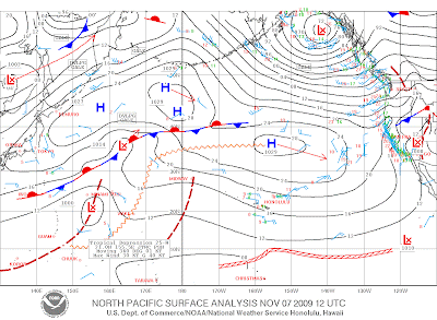
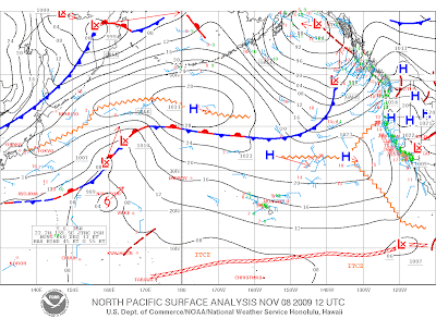
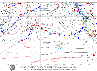
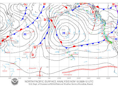
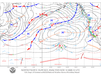
A trough in the jet stream pinched off into an eddy just NNE of Hawaii on Tuesday. At the surface, near gales to gales set up between a developing surface low pressure trough below the eddy and a strong surface high pressure Midway between Hawaii and Alaska. Gales nosed to within a hundred miles of Oahu on Wednesday as Waimea and Kailua buoy wave heights rose abruptly up to 18 feet. The initial stages of the episode were mostly from 000-030 degrees. On Thursday, buoys still show elevated heights with the direction slowly veering to 20-40 degrees. Quikscat morning pass shows the strongest area of winds associated with the westward-tracking surface low pressure to the N to NNW of Oahu, beginning to exit the Oahu window. Winds still within the window to the NNE to NE of Oahu out 600 nm have decreased to mostly strong breezes to near gales. Thus, the peak of the episode is likely Thursday morning. The direction should slowly veer toward 30-60 degrees on Friday as the heights subside, yet remain high.Now, Tuesday was the 10th and Thursday was the 12th.
Below are the weather maps starting from the 7th till the 12th. You guys see a fetch that can generate 22 feet, 15 seconds? I don't.
So I just emailed uncle Pat, maybe he will be kind enough to solve the mystery. My guess is that the maps were wrong...
Stay tuned on this post, eventually I will post his answer right here.

-------------------------------------------------------------------------------
Hereafter are the emails that I exchanged with Pat Caldwell and the wind graphic he attached.
email 1: Hi Pat, howzit!
When you got a minute, would you check my last post (some nices pics in
it!):
http://mauisurfreport.blogspot.com/2009/11/various-level-of-epicness.html ?
Where the hell was the fetch that generated that monster!? I don't
see it on the maps. What am I missing?
If that is a windswell, where is all the chop? I mean, look at those waves
at Lanes! They look just like waves of a serius groundswell that travelled
for days without active wind on it...
Help!!! ;)
reply 1:Hi Giampaolo,
thanks for sharing, great shots. that fetch stretched from about 100 to
600 nm away from hawaii. Winds reached gales with some pockets of
severe gales. Glad it did well on your spots. Bigger stuff not ridable
here, too messed up, but filtered spots on the inside had some nice
form. I had some epic kiting friday-sunday, give thanks
Aloha, Pat
email 2:Hi Pat,
thanks for replying. Clearly, I'm not done...
So, 100 to 600 nm is pretty damn close and the vicinity of the fetch
contributed to the lack of loss of energy for travelling, I was definitely
guessing that already.
But those weather maps still don't convince me.
What's gale to severe gale in knots? If it's more than 40, as I guess, it
doesn't seem to me that that high pressure, for high as it could have been,
could have generated such wind.
Or is Jamin (who just left a comment on my post) right when he says that the
maps didn't have enough resolution to show how deep that low that appears
barely on the 11th and then on the 12 was.
But even so, shouldn't it take a few days and a captured fetch to generate
such waves? I mean, we're talking 22 feet, 15 seconds!
And where did the chop go?
Sorry if I keep bothering you, but a few fundaments of my (presumed) wave
knowledge have been completely annihilated by this swell and I need some
comfort...
Thanks!!!
reply 2:Aloha Giampaolo,
Right, off basic meteor. chart, one may get a single ship report, and in
this case, a buoy (there is buoy 51000 NNE of Hilo now, it showed
gales), but one could not see the fine details.
It was the combination of a strong high and a "kona" low pressure system
that developed in the Hawaiian vicinity.
The best wind estimates over open ocean come from the QuikSCAT, see
attached:
http://manati.orbit.nesdis.noaa.gov/quikscat/
Hope that helps.

Well, it does help, thanks a lot... now at least I can see a fetch!
Still quite impressed by the size of the waves... I guess I'm not used to fetches that are so close to us and can't really predict their outcome.
I can tell you for sure (since I've observed them for eight years now) that if that same fetch was up there were most of the NW groundswells we get normally get in winter time are, the resulting swell we would have received would have been way smaller.
And this is based on the observation that to get a NW swell that big, it takes a way bigger fetch and/or way stronger winds up there.
So what I learned from this episode is that the energy dissipation of traveling waves is bigger than I thought.
I other words, never under-estimate close fetches!
The lack of chop still remains a shock for me, but sure I'm not going to complain about it! Evidently the lifetime of the chop after the active wind has stopped blowing on it is really minimal and it doesn't travel much at all...
Stoked that I learned something new. Mahalos uncle Pat!!! Good job with your kiting!


