7
Monday, February 28, 2022
2 28 22 morning call
Hookipa yesterday at sunset.

3am Surfline significant buoy readings and discussion.
South shore
Barbers is mostly reading NW wrap and can't be used to
detect small southerly energy. Check the Lahaina and Kihei webcam if interested, for
size, conditions and consistency.
North shore
NW101
5.1ft @ 13s from 322° (NW)
Hanalei
6.7ft @ 14s from 306° (WNW)
Waimea
5.8ft @ 14s from 311° (NW)
Pauwela
6.2ft @ 14s from 316° (NW)
3.6ft @ 10s from 358° (N)
NW swell still at the buoys (day four) now down to 14s. Today should be an excellent day of surfing on the north shore, as the wind should be light all day. Home guess for Hookipa is for around head and a half and clean.
Forecast of Pauwela from this PACIOOS page.

Wind map at noon. The other ones can be found here.

Fetches map (circles legend: red: direct aim, blue: angular spreading, black: blocked, yellow: possibly over the ice sheet) from Windy.
North Pacific (about 4 days travel time from the NW corner of the North Pacific):

South Pacific (about 7 days travel time from east/west of New Zealand):

Morning sky.

Sunday, February 27, 2022
Sunday 2 27 22 morning call
Hookipa yesterday. Photo by Jimmie Hepp from this gallery.

5am Surfline significant buoy readings and discussion.
South shore
Barbers is mostly reading NW wrap and can't be used to
detect small southerly energy. Check the Lahaina and Kihei webcam if interested, for
size, conditions and consistency.

North shore
NW001
8.7ft @ 15s from 303° (WNW)
Hanalei
9.9ft @ 15s from 314° (NW)
Waimea
8.1ft @ 15s from 306° (WNW)
Pauwela
7.7ft @ 15s from 317° (NW)
4ft @ 9s from 51° (ENE)
WNW swell down to 15s, but still pretty solid at the buoys. Direction turned less west and the consistency at Hookipa increased dramatically in the afternoon. Home guess for Hookipa is for head and a half to double overhead with no much wind in the early hours.
Forecast of Pauwela from this PACIOOS page.

Wind map at noon. The other ones can be found here.

Fetches map (circles legend: red: direct aim, blue: angular spreading, black: blocked, yellow: possibly over the ice sheet) from Windy.
North Pacific (about 4 days travel time from the NW corner of the North Pacific):

South Pacific (about 7 days travel time from east/west of New Zealand):

Morning sky.

Saturday, February 26, 2022
Saturday 2 26 22 morning call
Extra large waves on the north shore yesterday. This is Hookipa in the afternoon, photo by Jimmie Hepp from this gallery.

4am Surfline significant buoy readings and discussion.
South shore
Barbers is mostly reading NW wrap and can't be used to
detect small southerly energy. Check the Lahaina and Kihei webcam if interested, for
size, conditions and consistency.
North shore
NW001
11.3ft @ 16s from 298° (WNW
Hanalei
9.9ft @ 17s from 309° (WNW)
Waimea
8.9ft @ 17s from 304° (WNW)
Pauwela
5.8ft @ 18s from 306° (WNW)
4.5ft @ 15s from 314° (NW)
4ft @ 9s from 79° (ENE)
2.5ft @ 6s from 72° (ENE)
Extra large WNW swell continues at the buoys. Home guess for Hookipa is for inconsistent double overhead plus sets. Smaller and more inconsistent down the coast towards kahului.
Forecast of Pauwela from this PACIOOS page.

Wind map at noon. The other ones can be found here.

Fetches map (circles legend: red: direct aim, blue: angular spreading, black: blocked, yellow: possibly over the ice sheet) from Windy.
North Pacific (about 4 days travel time from the NW corner of the North Pacific):

South Pacific (about 7 days travel time from east/west of New Zealand):

Morning sky.

Friday, February 25, 2022
Friday 2 25 22 morning call
Hookipa yesterday at sunset.

4am Surfline significant buoy readings and discussion.
South shore
Barbers is mostly reading NW wrap and can't be used to
detect small southerly energy. Check the Lahaina and Kihei webcam if interested, for
size, conditions and consistency.
North shore
NW001
15.3ft @ 19s from 285° (WNW)
Hanalei
11.1ft @ 20s from 313° (NW)
Waimea
9.7ft @ 20s from 311° (NW)
Pauwela
4.6ft @ 20s from 315° (NW)
4.4ft @ 9s from 73° (ENE)
3.5ft @ 6s from 68° (ENE)
1.2ft @ 11s from 323° (NW)
New long period WNW swell vigorously ramped up at the buoys. Despite the massive 15ft 19s at the NW001 they're not gonna run the Eddie. The swell is pretty west (285 and 294 at the NW buoys) but it's big and long period enough to wrap around most upstream land masses. Below are the graphs of NW001, Pauwela and the Surfline forecast, which calls for 8ft 18s (after the wrap) at sunset. Home guess for Hookipa in the morning is for inconsistent overhead sets, building throughout the day but still with a slow arrival pace, much smaller towards Kahului. Kihei side will likely see some action too. Definitely too west for Honolua (north Molokai shadow line at 335), but with that magnitude, it's not impossible that once in a long while a set might somehow find its way there late in the day. And if it does, it might even be fairly big. Actually, the south Molokai shadow line for the Bay sits at 276, but I have no idea how it breaks if travels that way. Would think it tends to close out more.
Btw, to get to the graphs of the individual buoys, click on the Pauwela link and replace the buoy ID at the end of the web page address.
Forecast of Pauwela from this PACIOOS page.


Wind map at noon (two days old). The other ones can be found here.

Fetches map (circles legend: red: direct aim, blue: angular spreading, black: blocked, yellow: possibly over the ice sheet) from Windy.
North Pacific (about 4 days travel time from the NW corner of the North Pacific):

South Pacific (about 7 days travel time from east/west of New Zealand):

Morning sky.

Thursday, February 24, 2022
Thrusday 2 24 22 morning call
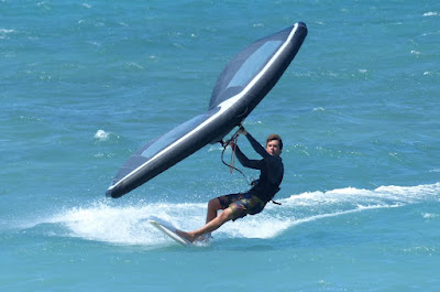
I came in from my downwinder while Andrea Crociara was ending a session with the wing on a 6.2 Kazuma surfboard. I asked him to go out one more reach so I could take a photo and he kindly did.
Image how happy he was to go back to his foil setup and experience drag free glides and the speed and freedom to do things like this.

This is a 5 minutes edit of my downwinder. Like a giant slalom with no gates.
6am Surfline significant buoy readings and discussion.
South shore
Barbers
2.2ft @ 9s from 179° (S)
0.2ft @ 25s from 306° (WNW)
Small short period energy at Barbers, check the Lahaina and Kihei webcam if interested, for
size, conditions and consistency.

North shore
NW101
2.8ft @ 20s from 288° (WNW)
2.3ft @ 12s from 297° (WNW)
Hanalei
3.5ft @ 11s from 328° (NW)
2.6ft @ 9s from 346° (NNW)
Waimea
3.3ft @ 13s from 318° (NW)
2.6ft @ 10s from 338° (NNW)
Mokapu
6.2ft @ 8s from 80° (E)
Pauwela
4.1ft @ 12s from 322° (NW)
3.5ft @ 6s from 63° (ENE)
3.4ft @ 8s from 57° (ENE)
2.5ft @ 9s from 333° (NNW)
Fun size 12s NW energy is at Pauwela while the NW buoy shows almost 3ft 20s of the new extra large WNW swell that will be here tomorrow. Below is the Surfline forecast that seems to be perfectly in line with the buoy readings (2ft 22s at 6pm should definitely produces some very inconsistent sets at sunset).

Below are the maps of Feb 20 through 24 that show the fetch that generated this swell. As you can see, it's going to be a very long lasting one.

Home guess for Hookipa in the morning is for head to head and a third high. Wind doesn't seem too strong through my windows.
No official call for the Eddie, but the fact that Surfline has setup a page where to watch it live seems to suggest that it's a probable go.
Forecast of Pauwela from this PACIOOS page.

Wind map at noon (1 day old). The other ones can be found here.

Fetches map (circles legend: red: direct aim, blue: angular spreading, black: blocked, yellow: possibly over the ice sheet) from Windy.
North Pacific (about 4 days travel time from the NW corner of the North Pacific):

South Pacific (about 7 days travel time from east/west of New Zealand):

Morning sky.

Wednesday, February 23, 2022
Wednesday 2 23 22 morning call
One Wheel to do a downwinder.
I did one in the water instead and it was a blast. Downwind conditions should be great also today and tomorrow, while Friday an extra large NW swell will make them much more challenging. The Eddie contest at Waimea is in yellow alert for that day.

Hookipa was getting some inconsistent sets in the afternoon.

5-6am Surfline significant
buoy readings and discussion.
South shore
Barbers is mostly reading NW wrap and can't be used to
detect small southerly energy. Check the Lahaina and Kihei webcam if interested, for
size, conditions and consistency.

North shore
NW101
4.3ft @ 12s from 316° (NW)
Hanalei
4.8ft @ 12s from 326° (NW)
Waimea
3.5ft @ 13s from 323° (NW)
Pauwela
3.5ft @ 6s from 66° (ENE)
2.9ft @ 8s from 56° (ENE)
2.8ft @ 12s from 320° (NW)
Small NW energy is at the buoys together with some easterly windswell. Home guess for Hookipa is around head high and blown out.
Forecast of Pauwela from this PACIOOS page.

Wind map at noon. The other ones can be found here.

Fetches map (circles legend: red: direct aim, blue: angular spreading, black: blocked, yellow: possibly over the ice sheet) from Windy.
North Pacific (about 4 days travel time from the NW corner of the North Pacific):

South Pacific (about 7 days travel time from east/west of New Zealand):

Morning sky.

Subscribe to:
Posts (Atom)


