Friday, May 31, 2019

Friday 5 31 19 morning call

I feel like starting this last post of May with a photo (by Tomoko) of my coworker Ayako enjoying the awesome conditions we've been having. May has been nothing short that excellent. South shore has had very few days below average, north shore has had some waves too with easterly winds and overall a fantastic weather.


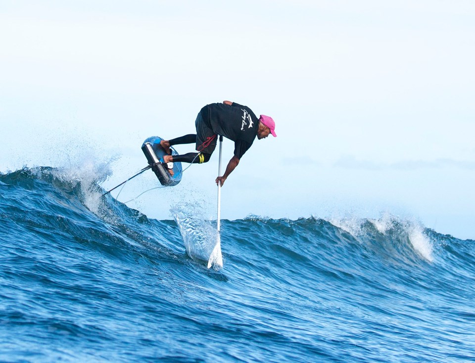
This is my pick of Jimmie Hepp's windsurfing photo gallery of the day at Hookipa.


5am significant buoy readings
South shore
Barbers
2.5ft @ 14s from 182° (S)

Lanai
1.9ft @ 13s from 170° (S)

South swell continues its decline while another pulse is expected to start building tomorrow.
Let's have a look at the evolution of the fetches in the collage above that groups the maps of May 24, 25, 26, 27 and 28. As you can see (click on the map to make it larger), the first map shows the last fetch that produced the current waves (an angular spreading one, so expect the consistency to be pretty low). Then on the 25th there were no fetches at all and on the 26th a new S one formed and that's what made tomorrow's swell. The timing (if morning or afternoon) will be more clear once we check the buoys tomorrow morning. I got a feeling it might be late in the day, but we'll see.


In the meantime, this morning the Lahaina webcam is not working properly, showing an image every minute or so. Hard to tell, but it's definitely smaller than it's been, so we'll call it a transition day with waves mostly in the knee to waist high range with some possible occasional bigger sets.


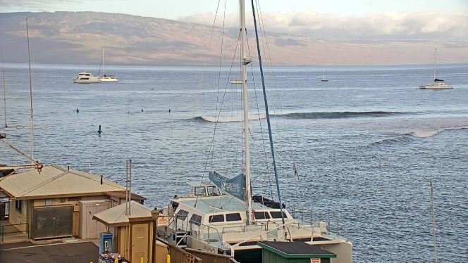
Well, as soon as I posted this, the webcam started to work properly and here's a killer harbor set. So check it out yourself, as there's still inconsistent sets here and there.


North shore
NW101
3.7ft @ 10s from 337° (NNW)

Hanalei
3.7ft @ 10s from 337° (NNW)

Waimea
2.9ft @ 11s from 325° (NW)
2.1ft @ 9s from 326° (NW)

Pauwela
3.2ft @ 8s from 77° (ENE)
2.7ft @ 6s from 81° (E)
2ft @ 10s from 322° (NW)

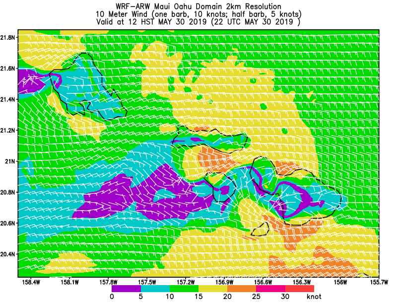
Only 2ft 10s from the NW at Hookipa plus a bit of windswell will only make for small waves at Hookipa, but not flat either. Probably waist to occasionally chest high.

Wind map at noon.


North Pacific has a tiny and weak leftover NNW fetch way up there.


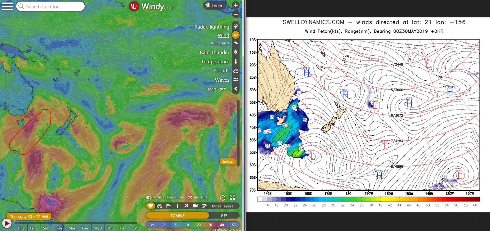
Is it then over for the north shore? Not even remotely so. Here's the map of June 6th showing another unseasonal low that is going to sit NNW of us and pretty close. That means: waves and trades from a direction between E and ESE. One week out, so things can change, but I don't think they will much.
That's a classic out of season swell that calls for a trip to Oahu to surf a pro-less north shore. Too bad I don't think I can do that.


South Pacific has a strong fetch occupying the whole Tasman Sea and extending over to the S and SE of New Zealand. I circled in red the two fetches from which we will receive waves in a week and in black the part that will be completely blocked by New Zealand. Nothing to be too excited about... unless you're in Fiji!


Morning sky.

Thursday, May 30, 2019

Thursday 5 30 19 morning call

I was taking photos of the foilers after my longboard session when Miki Eskimo showed up and started stretching right in front of me.
"Downward facing old dog?", was my teasing line.

To which, he replied with this quite impressive almost split. The hat is in honor of the recently passed away Niki Lauda, who was Austrian like him.

He went out followed by Francky's drone in order to get a shot to dedicate to the Formula 1 pilot.

Which I think he got right there. Probably not the easiest thing to foil looking up.

Will we ever see tandem foil boards with two foils? Probably not.

Shore break beauty.

3-4am significant buoy readings
Barbers
3ft @ 14s from 191° (SSW)

Lanai
2.6ft @ 13s from 175° (S)

South swell slowly declining through the rest of the week, but still providing fun size waves. The one in the screen shot below is head high, but check the webcam yourself before going, because it might have been the set of the day.


North shore
NW101
4.2ft @ 10s from 329° (NW)

Hanalei
2.1ft @ 9s from 339° (NNW)
2ft @ 11s from 317° (NW)

Waimea
4.5ft @ 9s from 329° (NW)

Pauwela
3.2ft @ 7s from 78° (ENE)
2.2ft @ 9s from 352° (N)
2.1ft @ 10s from 344° (NNW)

New pulse of short period NW energy has arrived, Hookipa will have waves in the head high range, getting bigger with the higher tide and active windswell in the afternoon. Another good day for the windsurfers, I'd say.

Wind map at noon.


North Pacific still offers a fetch, this time in a NNW position and very weak (not even 20 knots in most of it).


South Pacific has a solid fetch in the Tasman Sea, but the portion of it that won't be blocked by Australia and New Zealand is as narrow as the red circle I drew. And then, the waves will have to make through Fiji and and several other islands. So, low consistency and low expectations please, but there should be little SSW swell in a week.


Morning sky.

Wednesday, May 29, 2019

Wednesday 5 29 19 morning call

One week after my encounter with a section of the Lahaina reef, I was able to surf again. Just a short longboard session, it still hurts quite a bit. But that means I'm guilty to have driven to the south shore and not taking and photos (but I was busy with a lesson afterwards). Fortunately, I can always count on Jimmie Hepp to be shooting the windsurfers at Hookipa (if conditions happen and they sure are happening this week!).

This is my pick from his daily gallery.


Cody Young will have a surf camp for kids with special needs at Launiupoko on June 1st.


5am significant buoy readings
South shore
Barbers
3.9ft @ 14s from 181° (S)

Lanai
2.9ft @ 14s from 186° (S)

The very remarkable run of southerly energy continues. You look at the buoys, then you check the consistency and wind on the webcam and then you know enough to decide if to go or not. This is just a snapshot of a good set (I think I managed to get a guy in the barrel on the right), please don't base your decision on it.


North shore
NW101
4.4ft @ 9s from 357° (N)

Hanalei
3.4ft @ 8s from 36° (NE)

Waimea
2.9ft @ 9s from 343° (NNW)
0.6ft @ 13s from 277° (W)
0.5ft @ 15s from 272° (W)

Pauwela
3.2ft @ 8s from 60° (ENE)

Pretty confusing directions at the buoys, the one I trust the most is Waimea. As you guys will remember, there have been NW fetches (of intensity varying from strong to medium to weak) for at least 8-9 days now. Yesterday ended up having bigger waves than the day before (so I was told), today, if it stays like that, might easily end up being smaller. "Subtle up and downs" I called two days ago... maybe not that subtle.

All I wrote is confirmed by what Pat Caldwell wrote yesterday (which I only now just read): Waves arriving 5/28 were generated 5/25 about 1200 nm away. This event should peak 5/28 and drop below average 5/29 from 320-340 degrees.
The next fetch set up 5/26-28. It had a wider area of near gales with the reach closer to near 1000 nm away. This should bring in surf above the May average for Thursday 5/30 from 320-340 degrees. It should slowly drop into Saturday. Tiny surf from the same direction is expected to hold into Sunday.

Below is the collage of the maps of May 25, 26, 27 and 28.


Wind map at noon.


The North Pacific keeps having a NW fetch (which I forgot to circle). That low has been occupying the eastern half of it for many days. That also has pushed the seasonal high pressure more to the west (normally it sits where the blue H is). As a result, we are at the edge of it and we're getting calm mornings, slightly offshore winds in the afternoon, and overall a fantastic weather.


Good fetch in the Tasman Sea, not exactly oriented towards us, according to the great circle rays map on the right, but we might get a bit of angular spreading.


Morning sky. Gonna be another sunny one!

Tuesday, May 28, 2019

Tuesday 5 28 19 morning call

Oahu's Derek Hamasaki has been enjoying Maui's south shore waves. Photo by Chris Pagdilao.


Another really fun day for the windsurfers at Hookipa. This is my pick from Jimmie Hepp's gallery.


This is Julie Scheyer doing a foiling downwinder with her Duotone wing.
What do you think, we have enough variety in Maui? And I didn't even post a surfing shot!


4am significant buoy readings
South shore
Barbers
3ft @ 15s from 188° (S)

Lanai
3ft @ 15s from 198° (SSW)

Beautiful 3ft 15s reading at both the local buoys, it should be another great day of surfing on the south shore. Below is a head high one at the harbor, check the webcam yourself before going.


North shore
NW101
5ft @ 9s from 42° (NE)

Hanalei
4.4ft @ 9s from 4° (N)

Waimea
4.1ft @ 11s from 323° (NW)

Pauwela
4ft @ 8s from 72° (ENE)
2.4ft @ 11s from 339° (NNW)
2.1ft @ 6s from 83° (E)
2ft @ 12s from 333° (NNW)
 
Surprising lack of NW energy at the NW buoy. With all the NW fetches we had last week, Surfline has a pretty steady 3ft 10s prediction for all this week. Let's see if comes back up, but today it looks like it might be a bit of a small day. Webcam looks flat most of the times, but there are sets here and there.

Wind map at noon.


North Pacific still has a NW fetch, but pretty weak today.


Not much either from the South Pacific.


Morning sky.

Monday, May 27, 2019

Monday 5 27 19 morning call

Yesterday's conditions were similar to the day before at Hookipa, this is my pick of Jimmie Hepp's gallery.


This instead the shore break at Makena by James Dawson. I bet the lifeguards had to pull out the megaphone a few times to warn the visiting swimmers.


5am significant buoy readings
South shore
Barbers
3.9ft @ 15s from 184° (S)

Lanai
3.3ft @ 15s from 194° (SSW)

Good numbers at the buoys, it's going to be another day of excellent surfing. This is a snapshot of the Lahaina cam with a rare head high plus set. There's definitely waves, but the big sets are not particularly consistent, as it is characteristic of an angular spreading swell. Check it yourself before going.


North shore
Hanalei
3ft @ 10s from 322° (NW)

Waimea
2.2ft @ 11s from 316° (NW)

Pauwela
3.9ft @ 9s from 73° (ENE)
2.7ft @ 6s from 79° (ENE)
2.4ft @ 11s from 326° (NW)
 
NW swell definitely trending down today (disappeared from the NW buoy), but remember the fetches maps: there were NW fetches for the last 6 days, so the NW energy is going to last pretty much all week with subtle up and downs. Today might be a down kind of day (compared to the last couple of days), but at the same time Hookipa looks fun around head high and very clean in this windless start of the day.

Wind map at noon.


That low in the North Pacific stubbornly keeps offering a NW fetch for us. Nothing major, but enough to keep Hookipa away from the flatness also this week.


South Pacific has a beautiful long fetch oriented towards central America. Hopefully we'll get some angular spreading.


Morning sky.

Sunday, May 26, 2019

Sunday 5 26 19 morning call

The NW swell at Hookipa rose as predicted in the afternoon, here's an example of the max size I could gather from Jimmie Hepp's album.


4am significant buoy readings
South shore
Barbers
2.6ft @ 13s from 292° (WNW)
2.1ft @ 16s from 192° (SSW)

Lanai
2ft @ 17s from 194° (SSW)
1.7ft @ 13s from 198° (SSW)

New long period SSW swell on the rise at 17s, while the old one hangs in there at 13. Nonetheless, the waves are not exactly pumping in the webcam. Remember Pat Caldwell: As with the Mothers Day event, and as is most often the case from the New Zealand source region, highest aim of seas and swell were off to the SE of Hawaii. This places higher error bars on the local surf estimate.

This is a small set at the harbor, judging from they're sitting, there must be bigger sets. Check the webcam yourself before going. BTW, a kind reader sent me an email to inform you that Dumps is open again.


North shore
NW101
6ft @ 11s from 325° (NW)

Hanalei
4.1ft @ 11s from 318° (NW)

Waimea
3.9ft @ 13s from 305° (WNW)

Pauwela
5.4ft @ 9s from 81° (E)
3.1ft @ 12s from 322° (NW)
 
The waves at Hookipa look like head high on the webcam, but I'm sure there's bigger sets here and there. Conditions look allright with light sideoff winds up and down with the squalls. Should stay pretty steady all day, eventually building to yesterday's levels in the afternoon, if the wind will make the local windswell pick up a notch.

Wind map at noon.


The low started producing waves for us like 5 days ago is still hanging in there, greatly slowed down by the occlusion of its fronts. As a result, we get a small NW fetch also today.


South Pacific has a wide, but not particularly intense S fetch.


Morning sky. That's the tail of a front from the low that made the NW wave passing over us.