Tuesday, October 31, 2017

6.15am Hookipa has inconsistent waist to shoulder high very clean waves.

Tuesday 10 31 17 morning call

SUP and shortboard foiling sessions for me yesterday, the photo below by Tomoko speaks by itself about the pristine conditions we've been having thanks to the lack of wind. Those gently cut backs on the foil are so much fun!


Yesterday ranked pretty high in gorgeousness. Photo by Jimmie Hepp.


Yesterday was also the day after the Jaws contest and many more shots were posted on the social media. This is women's winner Paige Alms on a bomb. Check the incredible rescue happening on the inside. What a vision they must have had.


And this is that incredible 10 by men's winner Ian Walsh. Photo by Erik Aeder.


This photo by John Patao shows 13 years old Ty Simpson-Kane on his Jaws free surfing debut. Easy to predict he'll be in the contest soon.


4am significant buoy readings
South shore
N
1.6ft @ 14s from 196° (SSW)

Once again, the only southerly energy is recorded by the northerly buoys. Thousand Peaks had very inconsistent (sets were 10-20 minutes apart, sometimes even more) knee to waist high waves, with some occasional belly high bombs. Surfline calls for 1.3f 14s, so it should be similar today.


North shore
NW001
3.4ft @ 9s from 329° (NW)

Waimea
2.4ft @ 9s from 355° (N)
1.6ft @ 11s from 313° (NW)

The energy from the Jaws swell has disappeared, we're left with the shorter period declining energy from that northerly fetch closer to us. If you don't remember it, scroll down to the past days calls. Here's how Pat Caldwell describes it.
A weak, stationary low pressure system to the NNE of Hawaii 10/26-30 had strongest winds 10/26-27 with the tail of the fetch about 1600 nm. By 10/28, winds were moderate to fresh. This event peaked locally 10/28-29 and is dropping 10/30. It should fade out on Tuesday.

And here's how he describes the fetch of the next swell that in Maui will probably hit only tomorrow.
A new low formed east of Kamchatka 10/26 with lower-end gales that moved eastward over the 310-320 degree band into 10/28. As the associated front approached the Date Line late 10/28, the system occluded. This ended the energy from the WNW as winds to the west side of the low just east of the Date Line had highest seas aimed more north to south at targets SW of Hawaii.
Surf should build from 310-320 degrees Tuesday afternoon and hold at levels below average on Wednesday. It should drop from this direction Thursday.


So overall a pretty small day for the north shore's fall average, but with very clean conditions due to the lack of wind. Stay tuned for an early morning beach update from Hookipa.


My usual wind model didn't get updated, so we look at the two models at the bottom of the windguru page that show very little wind for today.


North Pacific shows a WNW fetch. Unfortunately part of it is behind the Kurils, but there's some wind also in front of them.
 

South Pacific shows a moderate fetch.


Morning sky shows some clouds moving in from the SE. 

Monday, October 30, 2017

7.30am Hookipa still has head to occasionally overhead clean waves.
8.5

Monday 10 30 17 morning call

Another double SUP foiling session yesterday, the first was pretty epic with rides from the reef to the beach at Kaa point. As the photo below shows, that's one Kilometer of flying. Kaa point is a new foiling spot (there all new!), which is a very poor surfing spot (waves are shifty and soft), but a phenomenal foiling spot since those bumps keep travelling and reforming on the inside.

The only other vessel I can think of that could ride them is a one man canoe (amazing glide), but that would follow a straight line like the yellow one. Foilers instead zig zag left and right (hence the go way faster), and in the end the distance covered is actually more than that. Plus, they're foilng and that's fun.


This is Honolua Saturday in a photo kindly shared by a shop customer.


And this is Hookipa yesterday at sunset.


5am significant buoy readings
South shore

NW001
1.3ft @ 14s from 204° (SSW)

Interestingly, the only buoy that shows southerly energy is the NW001. The surfline forecast calls for 1.2f 15s, so there should be a new low long period pulse.

North shore
NW001
4.4ft @ 9s from 16° (NNE)

Waimea
3.8ft @ 9s from 349° (NNW)
3.2ft @ 12s from 322° (NW)

Sizes and period are down from the weekend, but Hookipa should still offer up to head high relatively clean waves. Stay tuned for a beach report around 7.30am.

Wind map at noon shows a hint of trades on the north shore, but the other models call for no wind at all.


North Pacific shows two NW fetches.


South Pacific shows a fetch oriented towards central America of which we could possibly get some angular spreading.


Morning sky.

Sunday, October 29, 2017

6.30am Hookipa still has well overhead waves, not particularly clean because of the mixed periods I mentioned in the call.

Sunday 10 29 17 morning call

Double SUP foiling session for me yesterday, it's becoming a habit.

The Jaws contest was completed in the morning in pristine conditions and it was a great show again. The Maui surfers dominated and that's a confirmation of, no matter how good of a wave rider you are, the local knowledge is a more important factor. Ian Walsh and Paige Alms were crowned 2017 champions.

This photo is by Jimmie Hepp from this gallery. Can someone explain me how that can not be an interference? Fortunately Ryan Hipwood finished last in the final heat, otherwise someone might have been damaged by this "non call".


From a contest to another contest: today is the opening ceremony for the 2017 Aloha Classic, here's the schedule of events. There should be no competition for the first days due to the lack of wind, but the trades are predicted to return on Friday, as shown by the Windguru table below.


Talking about which, how to read that table is one of the topics of the agenda of the Meteo Workshop I threw down while watching the contest yesterday. Please leave feedbacks.

General knowledge    

- how waves are made: high and low pressures and related winds

- how waves travel

- refraction

- how waves break

Picking the right spot: Maui local knowledge

- how to read the Windguru Maui North shore table

- wind interaction with the mountains

- how to read the buoys

- Maui spots shadow angles

- Maui spots most effected by tides

Questions and Answers

No idea of when it will be held, haven't even looked for a room yet.

4am significant buoy readings
South shore

No southerly energy at the outer buoys, the Surfline forecast calls for a declining 1.4f 10s and a rising 0.7f 16s. That is very small stuff.

North shore
NW001
5.3ft @ 13s from 318° (NW)
4.9ft @ 10s from 339° (NNW)

Waimea
6.3ft @ 14s from 319° (NW)           
3.7ft @ 12s from 324° (NW)
2.8ft @ 9s from 346° (NNW)
2.7ft @ 10s from 332° (NNW)
Big swell tapering down to 14s period, but still with some juice. The problem will be the many other shorter period more northerly energy generated by the closer northerly fetch we've observed in the past few days which will make conditions a little less clean than they would have been with only one swell in the water. Fortunately the morning light offshores will help.
 
Wind map at noon shows very light wind.

North Pacific shows a NW fetch.


South Pacific doesn't show any fetches of relevance for the third day in a row.


Morning sky.

Saturday, October 28, 2017

Saturday 10 28 17 morning call

Double SUP foiling session for me, one with the old swell waves, the other with the new ones. First one had better wind conditions and it happened while the whole Jaws fleet was launching. Here Jason Hall pumps his way through the skis.
 
Kathy glides in the glitter.
 
The contest at Jaws was fantastic, the first two heats had the best waves, imo. Photo by Jimmie Hepp. This morning it will continue with pristine wind conditions. The live webcast page says "next call 6.30am" and if they're smart, they'll start right then. Men's semifinals (second one is stacked!) and Women's only heat.

Ian Walsh was able to navigate that worbly hollow section showing a impressive form.
Based on yesterday's performances, my pick for the win is one of these guys: Billy Kemper, Jamie Mitchell, Ian Walsh, Kai Lenny and Lucas Chianca. That is if Albee Layer doesn't find the barrels he's always hunting, which is quite possible with this morning's offshores.


5am significant buoy readings
South shore

No southerly energy at the outer buoys, the Surfline forecast calls for 1.5f 11s.

North shore
NW001
12.4ft @ 16s from 335° (NNW)

Waimea
12.1ft @ 17s from 322° (NW)

As the graphs of the two reported buoys shows below, the swell has peaked during the night. The period will be around 16-17s in the morning and the size is still solid, so more big waves on the north shore today, with a little more consistent sets.


Wind map at noon shows very light trades.
 North Pacific shows:
- a tiny west fetch from the next typhoon south of Japan
- a strong NW fetch oriented towards the Marshalls of which we should get a bit of angular spreading
- two smaller NNW and N fetches

South Pacific doesn't show any fetch for us.

Morning sky looks pretty clear. Should be a chilly morning. But at 10 it will be the usual 25 degrees C, the most pleasant temperature for a human body. Well, mine at least.
.

Friday, October 27, 2017

6am Hookipa already has extremely long period double overhead sets. Gonna get bigger all day.

Friday 10 27 17 morning call

Double SUP foiling sessions for meyestreday, both extremely sweet, but second one was kinda magic.

Today it's the day of the Peahi Challenge. Here's the link to the WSL live webcast
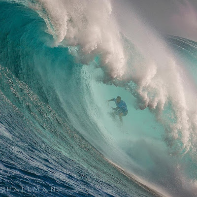
 page. Photo by Richard Hallman.
Good luck to all the competitors with a special mention to Joao De Macedo, a fine Portuguese man I had the pleasure to meet at the shop yesterday. He qualified for the contest at Nazare (so he's used to big waves), but he arrived two days ago, first time in Maui, and today is going to be the first time he surfs Jaws. That is a massive handicap compared to the local guys that surfed it tens of times.
"I don't care, I'll be just stoked to be out there!", he said.
"And when a big one comes you'll put your head down and paddle as hard as you can", I replied.
"Exactly!"
Good luck Joao. At that size, it won't be an easy introduction to Jaws (if there is such a thing).


4am significant buoy readings
South shore

No indication of southerly energy at the outer buoys, the Surfline forecasts calls for 1.9f 12s.

North shore
NW
10.1ft @ 21s from 346° (NNW)

Hanalei
5.4ft @ 22s from 329° (NW)

Waimea
5.9ft @ 10s from 339° (NNW)
2.5ft @ 20s from 304° (WNW)
2ft @ 16s from 293° (WNW)

You don't see 10f 20s often and if you get excited when you see it, you're just as weird as me.
Hanalei is up to 5.4f 22s, so the energy is definitely coming down the islands chain, while Waimea still has to feel the very long period stuff. I wonder if the mix of periods (specially the 6f 10s one) still in the water will bother the shape of the waves at Jaws, my guess is that it won't. Places like that are a natural high period pass filters.

Below is a snapshot from yesterday evening at 6pm. On the left is the readings and graphs of the NW001 buoy as proposed by the Surfline buoy page (link n.11). On the right is what you get from the NOAA page, from which you wouldn't have any idea of the fact that there is 23s energy in the water.
The reason is that Surfline breaks down the overall energy in all the different swells hitting the buoy at that moment, the NOAA only reports the significant (which is very non significant for our purposes) wave height, defined as:

the average of the highest one-third of all of the wave heights during the 20-minute sampling period.
That's the result of all the swells in the water. If you're gonna surf the open ocean waves right by the buoy (good luck), that might have some significance for you. Instead each surf spot will feel one swell more than another, depending on its direction, size and period. That's why it's much more important to know each single swell in the water. Provided you know what those swells will do at that spot, of course.


Let's now discuss when the swell going to peak in Maui. Below is the Surfline forecast for the Maui north shore (link n.15). I wrote down the information you would have if you go to that page and hover with the mouse over the arrows.
If you don't know what those couple of numbers mean, I strongly recommend you to attend the meteorology workshop I'm thinking about setting up. Please leave a comment if you might be interested, that'll motivate me to start preparing it, instead of surfing my ass off all day every day.

Now, that is a graph that has the size of the offshore swell on the Y axis. The size of the breaking waves will greatly vary from spot to spot, depending on the exposure to that direction (which for this swell is predicted to be around 325) and on the bottom of the ocean in front of the spot.
I personally don't know for sure when the peak of the swell will be at Jaws. I do know that the underwater canyon amplifies the longer periods more than the shorter ones, so we can assume that 10f 20s will make bigger waves than 11.6f 16s, so the peak should happen right after sunset.

Unless you're in the contest, finding a spot to surf on the north shore will be challenging as it will be a massive close out at one point during the day. Early morning will still be doable, after that look for sheltered places. Honolua Bay will be majestic, with the only variable caused by the fact that the wind will not be the usual offshore trades.

Wind map at noon shows very light sea northerly winds.


North Pacific shows a distant NW fetch and a closer N one.


South Pacific shows a small fetch.


Morning sky.

Thursday, October 26, 2017

Thursday 10 26 17 morning call

Double SUP foil session for me yesterday, this time I have the feeling I should have surfed instead.
Here's what I found. I like to foil on medium to low steepness waves, especially if there's bumps/sections to connect. Yesterday I was on a perfect down the line steep wave and I didn't quite enjoy the glide as much. I might be due to my poor skills, but next time I'll surf such conditions instead.
Still learning what's good for what.

Here's how the jetty wonder looked yesterday morning.


A couple of announcements.

The premiere of That’s Surf West, a windsurfing and surfing movie shot in Western Australia, will happen 7th November in Maui at Rock & Brews in Paia (free entrance, just buy your drink/food). Here's the link to the trailer.

 The workshop "Ayurveda and the Yogic Arts" with Brad Hay will be held Saturday November 18th, 9am to 4pm at Lumeria, 1813, Baldwin Ave.


5am significant buoy readings
South shore
The outer buoys don't show any southerly energy, the surfline forecast calls for 1.8f 12s.

North shore
NW001
8ft @ 11s from 1° (N)
5.4ft @ 10s from 3° (N)
4ft @ 15s from 298° (WNW)

Waimea
7.1ft @ 12s from 335° (NNW)
3.6ft @ 9s from 344° (NNW)
2.3ft @ 16s from 289° (WNW)
0.3ft @ 22s from 300° (WNW)
 
Still plenty 12s period northerly energy on tap today. The 15-16s period energy should be the west swell from typhoon Lan a few days ago. Also that sliver of 22s energy at Waimea belongs to that, IMO. Too early for the forerunners of the massive NW swell that could instead start showing in Oahu at sunset, but in Maui it's more like tomorrow.
 
Overall, the conditions on the north shore should still be very stormy (also because of the on shore wind).
 
Wind map at noon shows light north wind, stronger of course in Kihei.


North Pacific shows a long northley fetch and a NW one.


South Pacific doesn't show any fetch of relevance.


Morning sky shows that the front has passed but we're still covered by clouds.

Wednesday, October 25, 2017

6am Hookipa looked like a lot of disorganized white water from the distance and in the dark

Wednesday 10 25 17 morning call

A surfing (I insist) and a SUP foiling session for me yesterday and the second one was way more fun again.

The 2017 Peahi Challenge has been called on for Friday/Saturday, the photo is by Brent Bielmann from this page that also has the list of invitees.


4am significant buoy readings
South shore

No indication of southerly energy at the outer buoys which are "overwhelmed" by the strong NW swell. The Surfline forecast calls for 1.7f 14s.

North shore
NW001
13.5ft @ 12s from 350° (N)
6.4ft @ 10s from 343° (NNW)

Waimea
12.3ft @ 13s from 324° (NW)           
4.2ft @ 9s from 331° (NNW)
 
Higher than expected numbers at the buoys, here's an abstract from the NOAA page:
A storm low, several hundred miles north of the islands, has generated a larger than expected swell toward the Hawaiian Islands from a couple of days ago. Near- shore buoys are showing the swell up to 4 feet above wave watch guidance. The Hanalei and Waimea buoys are reporting swell heights of around 12 feet the past couple of hours, with a period of 12 seconds. This translate to warning level surf for the north and west facing shores of Kauai, Niihau, and Molokai, and north facing shores of Oahu and Maui.
Big stormy waves on the north shore today. Look for sheltered spots.

Wind map at noon shows light onshores on the north shore.


North Pacific shows the strong distant NW fetch producing the massive Friday/Saturday swell (12f 18s predicted by Surfline) and the remnant of the closer one that made today's swell.


South Pacific shows a tiny very distant fetch that won't do much for us.


Morning sky. Still some leftover rain as I type.