Wednesday, December 31, 2014

There was no need for a photo from Hookipa today. Big and stormy.

12 31 14 morning call

5am main swell buoy readings:

Waimea
11.2ft @ 10s from 331° (NNW)

Maui north shore (indicative of what's in the water on Maui's north shore)
    8.8ft @ 12s from 319° (NW)
5.7ft @ 9s from 331° (NNW)
4.9ft @ 8s from 322° (NW)

West lanai Maui north shore (indicative of what's in the water on Maui's south shore)
5.7ft @ 7s from 292° (WNW)
3.6ft @ 11s from 296° (WNW)

I hope you guys scored yesterday morning's pristine surfing conditions, because today it's going to be quite a different story.
The front has passed over Maui during the night and this is its position at 5.30am


Consequently, the wind is now blowing from a NW direction, like the picture below shows. I circled the fetch of N to NW winds that will keep the surf up until a longer period swell arrives over the weekend.


Below is the iWindsurf wind readings at 6.32am. From that and from the readings at the Maui buoy (and from the wind map above too), you can easily guess that Hookipa is not going to be the place where to surf today, since it's going to be extremely stormy.
You can also easily guess where it's going to be good, but that I leave to you.


Glad some windsurfers had fun at Lanes with the Kona wind yesterday, I'm not going to post any wind forecast for today because it's going to be light NW all day and that means no windsurfing.

Have fun in the sun everyone!

Tuesday, December 30, 2014

Despite the crowd, it was a lot of fun. Clean head high with no wind. Photo taken at 8.30.

Not much light because of the clouds. Scattered head high clean peaks. Ill try to post an update around 8.30

12 30 14 morning call

4am main swell buoy readings:

NW
5.1ft @ 12s from 315° (NW)

Maui north shore (indicative of what's in the water on Maui's north shore)
    4.6ft @ 12s from 338° (NNW)
4.2ft @ 9s from 22° (NNE)

West lanai Maui north shore (indicative of what's in the water on Maui's south shore)
    1.9ft @ 12s from 289° (WNW)
1.5ft @ 9s from 268° (W)
0.5ft @ 5s from 218° (SW)


New NW swell JUST started to show up at the NW buoy, so at that slow(er) speed at which 12s swells move, I'm guessing that we won't see ANY sets of that in Maui today. Maybe something at sunset, but not much. It's more of a tomorrow deal.
For info on travelling time from the NW buoy to Oahu, read this article on Surfline.

So let's focus on today, as usual, because tomorrow we don't even know if we're gonna still be alive. Sorry, that's how I see pretty much everything in life.
Below is the graph of the Maui buoy. You can observe a downward trend, specially in the NNW component, the dark blue swell, clocking in at 4.6f 12s from 338 as reported as usual at the very beginning of every "Morning call".
Well that's good news for most of the Maui surfers. Hookipa has been too big/confused for many in the last 2-3 days. Today instead it will be a lot friendlier, mostly head high, but with bigger sets.
I predict a very, very crowded lineup.


Also because the wind will be very favorable, as the wind map below shows.
I circled the usual fetch in the NW corner (how many days has that thing been there?!? Thank god for that!), and I also drew the wind directions east and west of an approaching front.
So today the wind will be SW and tomorrow, after the front has passed, it will be northerly. It always happen like this. Even in Europe fronts come from the Atlantic and behave the same exact way, so you guys don't be too surprised to see "strange" wind directions.


Here's a satellite photo that shows the position of the front at 5am, but that becomes obsolete pretty quickly, so you guys should check the animation on link n. 6 on the right.


Is the Kona wind going to be strong enough for windsurfing, I hear the wind addicted people begging. Well unfortunately the MC @ 2km website has not been updated at the time of this post. When yesterday I wrote that I consider it to be 95% accurate, I meant the first 24h of the forecast. Not so much the second 24h. Not at all, actually.
So in this case, we go back to the good old Windguru. Both the NAM and HRW models at the bottom of the page seem to agree that yes, it should be fairly strong in the afternoon.

So in summary we should have: epic clean (but crowded) surfing in the morning (photo from Hookipa coming up soon). Fun size kona wind sailing in the afternoon. I'll take it.

Have fun in the sun everyone!

PS. Thanks to all the readers for checking this blog. The numbers are increasing every day, so please keep spreading the voice. Also, I'll try to post photos from Hookipa more often during the day with updates on the conditions (like I did yesterday), so check this page often.

Monday, December 29, 2014

Hookipa is 10 knots sideshore and some fun overhead waves with occasional bombs. Low crowd. Jimmie is taking photos!

Theres doh bombs, even though they dont look too menacing because of the medium period. Very consistent ans a lot of work. Some clean faces.

12 29 14 morning call

5am main swell buoy readings:

Maui north shore (indicative of what's in the water on Maui's north shore)
    7.2ft @ 13s from 349° (NNW)
4.4ft @ 9s from 12° (NNE)

West lanai Maui north shore (indicative of what's in the water on Maui's south shore)
2.5ft @ 13s from 297° (WNW)           
 
1.8ft @ 9s from 304° (WNW)


I'd like to thank the reader that posted this comment on the last post:
"thank you for posting this. Im starting to actually understand this stuff."

Believe it or not, that's the main reason why I do this. The lack of knowledge (and abundance of laziness) of MOST surfers/windsurfers when it comes to understanding how waves and weather work is something that somehow annoys me. That's why I'm try to divulge a bit of knowledge. Not because I'm generous, but so that I won't be annoyed as much! :)
Anyway, that comment made me think that maybe I should try to explain real quick how to read a weather map. The easiest task of all, IMO, but such a still ununderstood one by many.

Below is today's weather map. Without getting into details of why the air moves the way it moves, just suck in the information that it moves clockwise around areas of high pressure and counter clockwise around areas of low pressure (the opposite in the southern hemisphere).
Those black circles around highs and lows are called isobars and the straighter and the closer to each other, the stronger the wind will be in that area.
In addition to that, the longer and wider that area (called fetch) is, the bigger the waves it will generate.
But all those words are obsolete, because now there's a graphic tool that explains it much better!


I'm talking about links n.2 and n.4 on the right, from which I below show a snip with arrows that illustrate the movement of the air. Please spend a moment to compare the two. They are exactly the same thing, just graphically represented in a different way.


Hope that helped someone (Jimmie, I was thinking of you...). Now let's talk about what's on tap for today.
Two swells at the maui buoy:   
a) 7.2ft @ 13s from 349° (NNW). Uh, that's a beautiful direction for the whole west side of Maui!
b) 4.4ft @ 9s from 12° (NNE). Nice direction for a bunch of other spots, but definitely smaller in size and most importantly in period.

One day I'll try to explain with my words what the period is/does, but in the meantime this is a good article on surfline. Have a read.

The great news is that finally the MC @ 2km website is working again (link n.17) and we have now a clear picture of how the wind will be in Maui all day, hour by hour. It can be wrong too, in the end the wind does whatever it wants to do, but I find it the most accurate and reliable. Like 95% reliable.
Well, it says that today, unlike yesterday when some knowledgeable sailors/kiters got some sailing down on the west side, it should be a pretty much windless day all day, so wax up your boards!

Photo from Hookipa coming up soon, even though I hope most of you know by now that 7f, 13s, from an unblocked direction like 349 means WELL overhead waves.
 
Have fun in the sun everyone!

Sunday, December 28, 2014

A 6f 13s nw swell means waves up to doh at Hookipa and that's what it is. Not clean though, because of the 9s n swell and the light sideon wind. 15 guys out.
It's cleaner than i thought though, but not clean enough for me to challenge such size. More work than fun with my poor skills.

12 28 14 morning call

4am main swell buoy readings:

Maui north shore (indicative of what's in the water on Maui's north shore)
    6.1ft @ 9s from 352° (N)
5.8ft @ 13s from 322° (NW)
           

West lanai Maui north shore (indicative of what's in the water on Maui's south shore)
    2ft @ 13s from 289° (WNW)           
           
 
The reason why I always start this morning call with the buoy readings is because I'd like you guys to read them before we get into the discussion.
They are the key to understanding what comes after.
Or, in other words, they are much more important than the discussion itself. They tell you 60% of the story. The remaining 40% being the local wind conditions.
This time I made an effort to weed out the small less significant swells (there were four at both buoys) in the hope to get your attention to it. Thank you.

Swell-wise, today we have a very similar situation to yesterday. The difference is that yesterday the onshore wind picked up only later in the morning (and the few that listened to my advice to go get them until it lasted, scored fun sessions), this morning is already on it. And it's been on it for more than 24h, so expect the water to be particularly messy.
 
The other side effect of the north wind is the drop in the temperature (58f/14c the low in Paia yesterday).
In the water it's still relatively warm, but with the wind chill factor, on land it can get relatively chilly too. Yesterday I froze my ass off running from the shower to my car after a sunset session and I thought:"how the hell do they surf in winter time on the east coast?!?". Respect to the cold water surfers of the whole world.
 

Below is a satellite picture that shows the classic little dots clouds that indicate more cold air arriving.


That is reflected also by the wind map below, in which I circled the usual fetch in the NW pacific that is kindly making sure that we will have continuous waves from the NW for the whole next week.
I also put an arrow to indicate the wind direction right now in Maui. I call that straight onshore and for me there is not a chance for trade winds to blow for the desperate windsurfers (some of them were sailing along the beach at Kanaha yesterday).


But in reality, without the MC@2Km website, no one really knows what the wind is going to do.
Take the two models at the bottom of the windguru page, for example. One of them even predicts a wind direction of 72 at 4pm, going into 76 at 5pm. Those are getting very close to the regular trade wind direction (which I consider to be 75 to 85), but after having analyzed the evolution of the pressure at sea level (link n.0 on the right), I give that forecast a very, very low confidence factor.

Should I add a summary at the end? Let's see if you guys like it. Today it will be:
very poor surfing conditions and no trade winds windsurfing. Ok, maybe I should have chosen a better day to start that...

Nonetheless, if you're in Maui you're in one of the most beautiful places in the world, so make sure to have fun in the sun everyone!

Saturday, December 27, 2014

The wind died. Doesn't look as bad. Get it until it lasts!

(Dazed and) confused breakers. Still surfable, but a hell lot of work.

12 27 14 morning call

4am main swell buoy readings:

NW
6.5ft @ 8s from 354° (N)
5.4ft @ 13s from 311° (NW)
4.4ft @ 10s from 51° (ENE)

Waimea
6.2ft @ 9s from 6° (N)
2.9ft @ 13s from 332° (NNW)
2ft @ 4s from 333° (NNW) 

Maui north shore (indicative of what's in the water on Maui's north shore)
6.7ft @ 9s from 1° (N)
2.3ft @ 15s from 326° (NW)
2ft @ 4s from 327° (NW)

West lanai Maui north shore (indicative of what's in the water on Maui's south shore)
    2.5ft @ 5s from 285° (WNW)
1.4ft @ 12s from 208° (SSW)
0.9ft @ 9s from 277° (W)
1.2ft @ 7s from 264° (W)


From Pat Caldwell's forecast summary: "overlapping remote and nearby swell events making for confused breakers on northern shores. "
That most definitely sums it up.
A new long period NW swell generated by that big wide fetch to the NW corner of the pacific that I pointed out often in the previous posts is arriving today and is mixing up with the short period N swell that is being providing us with really fun waves for the past few days.
Here's the graph of the NW buoy that shows the NW swell not really ramping up all that much.
It's the light blue line. The dark blue line is the N swell. And the black line is the sum of the energy of the two swells and it's the reading you get if you go to the NOAA website instead. Extremely deceiving, I'd say.


Anyway, even mixed up swells will give life to clean surf if the wind were right.
(Sorry, I just got to say how much I hate this grammar rule in English... that doesn't make any sense, it should be "if the wind was right", but I believe it's not!!)
But unfortunately, the wind is not right.
Below is the wind map with the usual two fetches (NW remote one and N close one) we've been observing for quite a few days now.


This instead is the close up that shows how close that fetch is today. For the surf to be good, the fetch needs to be at a longer distance from the breaks, so that the different period components of the swell can separate from each other (long period travels faster than short) and hopefully the wind at the break will be right.
In this case, the head of the fetch is so close to the islands that we're actually getting a bit of active sea with NW wind on it! Plus, don't forget the overlapping of the remote NW swell...


This is the iWindsurf map at 6.36am and it shows right that: 10 mph from WNW at Hookipa... that's why I'm taking it easy this morning.
But it also shows 4mph from SW at the harbor, so there might be clean conditions somewhere for... who knows how long.

The onshore wind will be the problem during the weekend, you really need to be creative to find a good spot. I hope the info I just provided you with will help.

PS. Windsurfing has been cancelled also the whole next week.

Have fun in the sun everyone!

Friday, December 26, 2014

Fun short period head high peaks

12 26 14 morning post

4am main swell buoy readings:

Maui north shore (indicative of what's in the water on Maui's north shore)
    7.5ft @ 9s from 46° (NE)

West lanai Maui north shore (indicative of what's in the water on Maui's south shore)
    2.3ft @ 9s from 279° (W)
1.6ft @ 6s from 279° (W)
0.6ft @ 3s from 302° (WNW)

I noticed that these days the "regular" wave forecasts are quite off. Both Pat Caldwell and Surfline (the two that I check) are not calling the sizes that the buoys are reading. I believe both greatly base their forecasts on the WW3 wave model and that must need some fine tuning when the swell is closely generated like the 7.5f 9s out of the NE one we have on tap today.

Yesterday was another gorgeous day of surfing in Maui. I had two really good sessions before getting skunked by a sudden change of the wind at sunset time. It went onshore on the north shore and I'm still trying to figure out why, since today is back to light westerly.
Unfortunately the MC@2km website is not being updated since last sunday and that is a big piece of information missing.
As I say often, the wind in Maui is the most important factor (provided that there's waves). Don't wait for the right tide you guys if the wind is good when you're checking a spot!

Wind map below shows the usual very comforting wide fetch of NW winds (even though kinda light) on the top left corner and another smaller but closer fetch of NNW-N winds. These are the directions we should be observing at the buoys in the next few days, but on this page I like to focus on the conditions of today. It's called morning call for a reason...
So local westerly winds again. Let's talk about it over the closeup map down below.


Just like there will never be a swell out of pure west on the Maui buoy, it's pretty much impossible to register a pure westerly wind on the north shore. The reason is that the West Maui Mountain will block it and deviate it. Depending on the angle it hits it, the wind will either hug the Mountain on the south and blow from WSW on the north shore (like yesterday it did all day until 4pm) or hug it on the north and blow on the north shore from a dreadful NW direction.


Right now at 7am it's definitely got a southerly component and that is great. But it is supposed to turn NW at one point. And without the MC@2km maps, we can only have a look at the much less reliable NAM and HRW models that you find at the bottom of the windguru page. They both predict the change of the wind between 11am and 1pm, so the message is clear. Get them before the wind switches!
Where to go? Man, NE is such an easy direction... it pretty much gets everywhere! Sorry, no help there!


Have fun in the sun everyone!

Thursday, December 25, 2014

Lots of big beautiful peaks at hookipa. Bit too big for me.

12 25 14

4am main swell buoy readings:

Maui north shore (indicative of what's in the water on Maui's north shore)
11.1ft @ 12s from 359° (N)

West lanai Maui north shore (indicative of what's in the water on Maui's south shore)
 2.7ft @ 12s from 281° (WNW)
1.7ft @ 8s from 261° (W)
1.4ft @ 9s from 282° (WNW)


I really hope some of the readers are scoring good sessions thanks to the info on this blog.
I most definitely am. The last three days my sessions were all 8s or higher...

Once again, big not so powerful swell from the north (11f 12s). Love it.
Also because the two spots I'm gonna surf with this size and directions, one likes high and the other low tides. I only hope I'll be able to recover soon enough between the two... I do the same kind of stuff when I'm in Bali.
I never talk about the tide, unless there's something extreme or particular about it. Also because tides in Hawaii are not particularly important in most cases. Some spots do feel it more then others, but most spots it doesn't matter all that much.
You can read it yourself (link n.12 in the list on the right).

Below is the wind map that shows a lovely low that formed just north of us. I remember mentioning that like a week ago, in the middle of a very windy period, and I was looking forward to the change.
Because of the counterclockwise circulation of the air around a low in the northern hemisphere, today the wind will be light and from a very unusual westerly direction.
I also circled a wide (but not particularly intense) fetch to the NW that will provide us in the next few days with continuous waves from that direction.
I forgot to circle the fetch to the left of the L that is sending us these super fun waves from the N, but I hope you guys are starting to be able to identify the fetches pointing towards us without my help.
Pretty easy task, after you pay attention to it a few times, I'd say.
The north fetch is way smaller than the NW one, but it's far closer to the islands and that's why we're seeing these sizes at the buoy. Waves travel in an amazingly efficient way, but they do lose energy by doing so.


Talking about wind (by far the most important factor for surfing in Maui other than the swells themselves), I quickly checked the weather maps 7 days ahead (link n.1) and that low is going to stay there for a few days not allowing any chance to the trade winds to come back.
I know there's a lot of windsurfers that came to Maui to spend the holidays hoping to score some sailing, but it's winter time and the wind is not guaranteed at all.
Grab a surfboard or a SUP you guys and enjoy paradise anyway.
That's all I have to say today. Did you grab your maui map and figure out where to surf on a straight north?

Have fun in the sun everyone!

Wednesday, December 24, 2014

Too disorganized

12 24 14 morning call

7am main swell buoy readings:

Maui north shore (indicative of what's in the water on Maui's north shore)
    9.4ft @ 9s from 3° (N)
7.7ft @ 13s from 322° (NW)

West lanai Maui north shore (indicative of what's in the water on Maui's south shore)
    3.4ft @ 13s from 279° (W)
2ft @ 9s from 283° (WNW)
 

Sorry, bit late this morning...
Two big swells at the Maui buoy. But let's talk about the wind (or lack of thereof) first.

Below is today's weather map. The tail of yesterday's front is still sitting on the islands. Look at how the isobars are interrupted by it. Without it, the southern edge of that massive high pressure would have perfectly straight isobars and the wind in Maui would be in the 30+ category.


Instead, look at how we are right now in the middle of a small area of very light to no winds.
I clicked on a point on Maui's north shore and the map below indicate and estimate of 5km/h wind. That's pretty much nothing and that's pretty much what we have right now at 8am: no wind.
That you dear frontal system for that.


Careful though that the rain might not be over yet. This 7am satellite image still shows some clouds and in the area I circled it's still pouring (Molokai getting a bit pounded).


Well, now that we got the wind part down, let's go back to our two swells:
9.4ft @ 9s from 3° (N) and 7.7ft @ 13s from 322° (NW).
Obviously, if you choose to surf a spot that is open to both directions (like Hookipa), you're gonna have both swells interacting with each other. That is not necessarily a bad thing. It might add more peaks, and might keep the crowd down because it won't look picture perfect.
If you choose instead a spot that is only open to one of the two directions (or open to one more than the other), you're gonna have a bit more clean and easy to read conditions.
Notice also that the N swell is bigger in size, but shorter in period. So which one is going to be bigger when it breaks?
That depends greatly by the spot and by how open it is to those directions.
That's why I can't give you a general rule. It really depends on each spot and swell. Beware of formulas you can find on the internet... I consider them useless.
In this particular case, JUST FOR HOOKIPA, I can predict that the NW swell will generate waves that are up to doh (double over head), but not particularly steep, powerful and throwy.
The N swell instead, will be probably up to a head and a half (sorry, you will NEVER hear me calling the heights of a breaking wave with the non sense hawaiian scale... I use body parts instead) and well mushier than the NW one.
The interaction of the two can generate all kind of different sizes, depending on the arrival of each single individual wave. Imagine two sets of those two swells arriving at a time that will make the peaks of two waves overlap. The height of the resulting wave will clearly be bigger than the single waves. A little later in the sets (provided they have enough waves in them), because of the difference in period, it might well happen that the peak of one wave will happen simultaneously to the trough of the other one and the height of the resulting wave will clearly be smaller.
That's how Hookipa will be (geez, all this forecasting about Hookipa without even having seen it yet... and it's at a 2 minutes drive from home! I better go double check as soon as I'm done with this!!!). Very variable sizes (and breaking patterns) because of the interaction of two swells.
If you don't like the idea of getting caught inside by a double up wave and having to paddle your ass off to make it out again (I'm predicting lots of that), grab a map of Maui, try to pick a spot that might favor one direction more than the other. Go see how it looks over there and build your knowledge of each single spot. You do have to remember the swell size and direction though.

Have fun in the sun everyone!

Tuesday, December 23, 2014

12 23 14 morning call

4am main swell buoy readings:

Maui north shore (indicative of what's in the water on Maui's north shore)
9.7ft @ 9s
6.1ft @ 12s from 319° (NW)
5.4ft @ 15s from 316° (NW)
2.5ft @ 3s from 2° (N)

West lanai Maui north shore (indicative of what's in the water on Maui's south shore)
3.8ft @ 15s from 280° (W)
2.1ft @ 9s from 283° (WNW)
2.2ft @ 5s from 309° (WNW)
   

Well the call is particularly easy today: it's a mess out there.
Look at the mix of swells above at the Maui buoy ( for some reasons the 9s one doesn't say the direction, but I'm gonna guess from North) and you'll suspect that even with no wind it would be fairly stormy and disorganized.
Add the 19mph onshore wind that the iWindsurf sensor is reading at Hookipa at 6am (should be pretty steady onshore all day) and you'll understand that you won't need a photo or a report today. It's as messy (and dangerous) as it gets today.

I'm gonna need my usual fix before work, so I'll probably surf Paia Bay (one of the very rare times in which I disclose where I'll surf... really don't mind if someone shows up, since I'm gonna be most likely all alone there), but if you have more time in the morning you could go surf the other side.
I went Makena side yesterday and there were some beautiful waves, even though with very long waits. I was told the north shore had long waits too and that is one of the side effects I observed about the refraction/shadowing.
  
You could also go Lahaina side, since there's still a bit of south swell (overshadowed by the WNW wrap at the Lanai buoy). As usual, check the Fish Company webcam before getting in your car if you want to check the size/local wind.
But if you're curious about what made those waves, here the south pacific weather map of 7 days ago. I circled the fetch SE of New Zealand that made those waves and I drew a loooong line and tried to place where Maui sits on that map.
I also spotted a tiny fetch in the Tasman sea that sent a small swell to Fiji.


Below is the wind map of today. I circled three fetches. N.1 is a good one and will send us yet another NW swell during the weekend (7f 14s is surfline's call).
The other two are bad, since they're very close and are generating short interval disorganized waves from the N and the NE.


Below is the 5.30am satellite photo that shows that today it's gonna be rainy/cloudy.


Hey, it can't always be paradise in paradise... have fun in the sun everyone! It might come out at one point!

Monday, December 22, 2014

Theres some bombs. Too big for me.

12 22 14 morning call

4am main swell buoy readings:

NW:
11.2ft @ 16s from 281° (WNW)
8.1ft @ 10s from 329° (NW)
3.5ft @ 8s from 336° (NNW)

Waimea:
9ft @ 17s from 312° (NW)
1.8ft @ 9s from 350° (N)
1.4ft @ 11s from 320° (NW)
1ft @ 5s from 50° (NE)

Maui north shore (indicative of what's in the water on Maui's north shore)
    6.7ft @ 17s from 317° (NW)
4.2ft @ 9s from 74° (ENE)
3.5ft @ 11s from 332° (NNW)

West lanai Maui north shore (indicative of what's in the water on Maui's south shore)
    3.7ft @ 17s from 285° (WNW)
1.4ft @ 9s from 194° (SSW)

Great post today, lots of stuff to talk about.
Once again, you guys need to carefully read the buoys readings above to understand what I'm going to say.
Let's start from three buoys together: NW, Waimea and Maui.
First notice that the scale for the NW graph is different (20 feet top of the Y axis, versus 12 of the other two). Then notice how Waimea (and consequently also Maui) hasn't peaked yet.
And lastly notice how the direction of the swell at the NW buoy went even more west in the last few hours (red arrow pointing at the blue line). I do remember the fetch doing that, so no surprise there (for me at least...).
That direction change WILL NOT be reflected by the directions we'll read at the Maui buoy later in this swell. Once again, the Maui buoy can't register anything more west than around 310, unless a meteor lands in the water in Waiehu or outside the Kahului harbor.
I hope this will be more clear after I discuss the next picture.


Now, that's some good info below. Let's look at the north section of the pic below first. I drew two lines that show the directions of the swells picked by the Waimea (312) and the Maui (317) buoys.
Don't forget that the original direction of the swell before it gets refracted by Kauai AND all the upstream uninhabited islands that we all forget about, is around 290.
See why the Maui buoy won't show anything more west than around 310? Because there's the West Maui Mountain and Molokai! So what is a change of 10 degrees more west of the original swell going to do on the north shore? The direction will still be more than 310, but the energy will be less.
Don't forget, the more a wave gets convexly refracted (or defocused), the more energy it loses.
Also, the period of the swell will go down and the lines will be refracted less. So don't be surprised if tomorrow it's going to be a smaller than today.


But now let's look at the southern part of the pic.
The Lanai buoy is reading 3.7ft @ 17s from 285° and I drew a line from that direction.
What is totally unknown is how much that direction is going to change after the refraction around the southern tip of Lanai. If the direction changes to straight west (270), the whole Kihei coast will have waves. But we have no means to predict that. That's why you guys that live over there should write down direction and sizes and build your own database of observations... yeah, right.
And why is the size only 3.7f I hear you saying?
Well that's because the swell has already been refracted by the southern tips of Niihau AND all the other upstream islands and that's what it is. Don't forget that the bulk of the swell will move north of the islands. Go down a few posts if you don't remember the position of the huge fetch that generated this large swell.


Uff, that was a lot of explaining. I hope you guys will remember this post. I should actually label it "refraction" so that it will be easy to find for future reference.
The really good news is that the dreadful onshore wind won't hit until tomorrow! Hurray!
But once it will hit, the waves will be ruined for quite a while. Look at the fetch of northerly wind I circled in the picture below and imagine how much chop and short period waves from the north that thing is going to send....


Yesterday two persons in the lineup thanked me for this blog. Two ladies, actually, one of which even blew me a kiss for that. That's a way of motivating me. Blew me kisses if you like this blog! If you're a guy, just say thanks.
And spread the word in the lineup, on the beach, on social media, etc. Once again, this might be a one season only experiment if the number of readers doesn't increase significantly.

And since I'm talking to my readers, here's the most common question I get:"why don't you clearly write down where to go surf?"
The answer is:
- well first sometimes I don't even know and I need to check Hookipa first (that's when I post the photo)
- even if I know where I'm gonna go, I don't want anybody to join me because it read it on the blog
- and even if I know where to go surf, that's my personal choice based on my personal skill and my personal preferences. What the hell a reader like Yuri Soledade cares where I'm going surfing? He's probably going to paddle Jaws this morning! But he does read my blog because he finds it interesting (thanks for that!).
You guys should do the same. Use the info you read here and build your own knowledge and take your own decision.

Have fun in the sun everyone!

Sunday, December 21, 2014

Clean head high lines from the old swell. Nothing yet from the new.

12 21 14 morning call

4am main swell buoy readings:

NW
5.2ft @ 19s from 286° (WNW)
4.7ft @ 9s from 127° (ESE)
4.4ft @ 12s from 309° (WNW)
 
Waimea
3.5ft @ 12s from 313° (NW)
1.5ft @ 20s from 305° (WNW)
1.4ft @ 5s from 45° (NE)
1.4ft @ 9s from 356° (N)

Maui north shore (indicative of what's in the water on Maui's north shore)
5.4ft @ 9s from 77° (ENE)
3.3ft @ 12s from 336° (NNW)
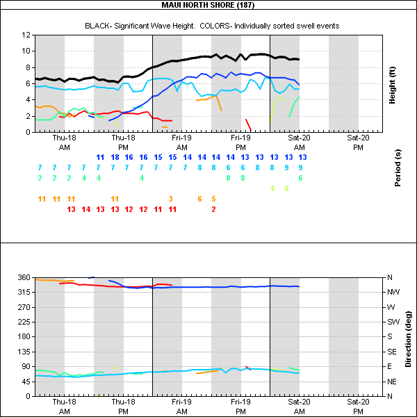
1.7ft @ 5s from 78° (ENE)

West lanai Maui north shore (indicative of what's in the water on Maui's south shore)
1.7ft @ 15s from 202° (SSW)
1.3ft @ 9s from 192° (SSW)
1.1ft @ 8s from 182° (S)
1.1ft @ 12s from 256° (WSW)
   
It's all about the buoys today. Read the measurements above, before reading below, please.
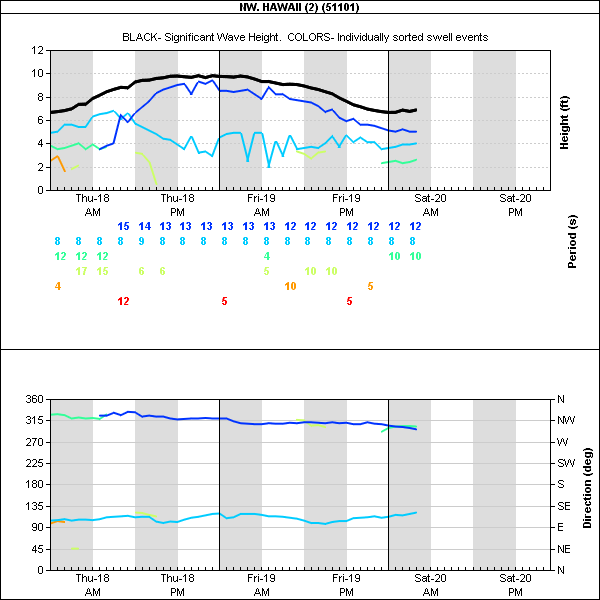
Below is the graph of the NW one that shows how the new swell started to pick up during last night (dark blue line).


20s travel fast, so we actually can see something already at the Waimea buoy (light blue line in the graph below).

I'm gonna use the graph above to show you why you should not check the buoys on the NOAA websites, which readings I report below. There are no sign of anything with period longer than 13s, so if you only look at that, you would think the swell is not even in the water.


The reason is that the table below only reports ONE swell. It's a little bit like checking the wave forecast on windguru: one ONE swell is reported, the one with the biggest size, regardless of the period.
Somewhere on the NOAA website though, there's the info of the energy distribution per period and what Surfline does (and plenty other websites, I'm sure), is that they analize that information and break it down per single swell.
No go back quickly at the waimea graph above.
See the black thick line? That's the (only) size you would gather by reading the NOAA readings.
Look how much smaller the 20s swell is compared to that.
In other words, the NOAA way of presenting the buoy readings CAN be extremely misleading.
I say CAN, because it's not always like that. When there's only one swell in the water or when one is WAY bigger than the other ones, then the NOAA reading can be ok.
This might happen tomorrow for example, when this big swell will have completely filled in.

Smarty pants they call me... smarty pants I feel.
As a matter of fact, I'm not even done.
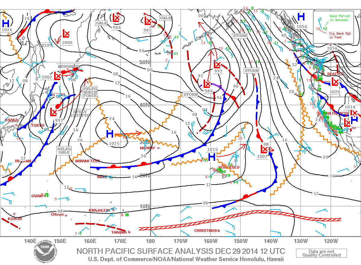
Let's look at the directions now: 286 at the NW, 305 at the Waimea, nothing still at the Maui buoy.
But directions like that get "influenced" greatly by Molokai and all the other upstream islands.
The influence depends on the period. As I was saying a couple of days ago, the longer the period, the more the waves have the ability of refracting.
But while Pipeline was an example of concave refraction in which the energy of the wave gets focused on a shallow spot in front of it, wrapping around a point of land is an example of convex refraction and the energy of the wave gets defocused and spreads (wraps) around the point.
That's why point breaks are usually fun, wally but not too powerful waves (don't be fooled by waves like honolua, because yes it is a point break, but it also has reef underneath it's both a point and reef break!).

All this to say that:
- yes, we are going to see waves from this swell in Maui, but for sure they are not going to be as powerful as they will be in Kauai
- in the morning there will be absolutely no waves from this swell in Maui. It's more like an afternoon thing and the more east you go on the north shore, the better the size
- the direction will be quite west, but there is no chance that we're gonna see 286 at the maui buoy. That would mean that someone is generating waves outside the Kahului harbor! :)
- there is a chance of waves in Kihei/Wailea. I'm definitely not an expert of this coast, but I know that westerly swells can hit there.


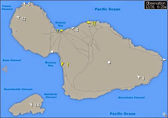
The other relevant thing to say about today is the beautiful lack of wind of any kind all day.
Check the wind map below. One high is about to replace the other. In the meantime today it's calm, but as soon as the front between the two highs hits, the wind will turn northerly and stay like that for a week! And I don't need to say how bad that is for the waves on the north shore. So save some money for the gas, there will be some driving to be done next week.
Thanks for reading all this. Please make an effort to spread the word about this blog at the beach, because I'll only do this this winter if I don't see the numbers of readers growing. Thanks.


Have fun in the sun everyone!

Saturday, December 20, 2014

1.30 and, as predicted, too many surfers in the water for the windsurfers to go out. Theres 2 at lanes. I surfed 2h ans sailed 1h. I can go to work.

Lines in the dark

There's still overhead sets, but not that frequent. Wonna be the first one in the water, because it is going to get crowded today. No wind at the moment.

12 20 14 morning call

4am main swell buoy readings:

Maui north shore (indicative of what's in the water on Maui's north shore)
6.2ft @ 13s from 334° (NNW)
5.8ft @ 9s from 69° (ENE)
2.9ft @ 4s from 79° (ENE)

West lanai Maui north shore (indicative of what's in the water on Maui's south shore)
   
2.4ft @ 13s from 290° (WNW)
1.2ft @ 16s from 220° (SW)


1ft @ 5s from 165° (SSE)

6f 13s IS my favorite size to surf one of favorite spots and you can be sure I won't miss that opportunity if the visual observation will confirm that.
Sorry I need to be more precise: 6f 13s on a declining swell (would not be out there on a increasing one). And the swell is declining, as the NW buoy graph clearly shows below.


This is the graph of the maui buoy instead. You can see how it started to decline during the night, while it was pumping all day yesterday.


Since I got the compliments for a good call from one of the Hookipa windsurfing photographers, I'm gonna try to call the wind again. Below is the wind map (at 6am).
I circled the fetch NW of us that is still producing the big swell that will hit on sunday/Monday.
I also circled the circulation of the air around the high pressure cell that is moving east and I tried to drew an arrow with the wind direction of today.
Hopefully you can see that it's ESE.
I then did a zig-zag scratch on the area of light wind that will delight us tomorrow with some epic surfing conditions that unfortunately are only going to last one day, before the winds will turn north.


One more map for the windsurfers/kiters. MC2KM at 1pm shows how offshore the wind will be.
Looks like windsurfing might not happen at all down the coast and considering that the waves will be a lot smaller than yesterday, I'm not even sure it will happen at Hookipa!
The surfing will be clean (well... maui clean!) all day and it's a Saturday, so the 10 man rule might keep the windkooks out of the water! I work at 2, I'll try to post pics from the beach to update you guys of that situation.


Wait, one more!
See those 1.2ft @ 16s from 220° on the Lanai buoy? That means there's small waves on the south shore (you can judge the size by yourself on the lahaina fish company webcam when the sun will be out) and below is the map of the southern pacific of 7 days ago that show a nice fetch just east of New Zealand that generated them.


Have fun in the sun everyone!