Thursday, December 31, 2015

Beautiful clean head high but rising waves at Hookipa at 8

12 31 15 morning call

Yesterday was such a poor conditions day pretty much everywhere that I didn't even look for a local action shot. So I'm posting this shot of Michelle Bourez by Ben Thouard. Not sure when it was taken, but click on it and observe the scary reef right in front of the massive wave. Tahiti is a place that I would love to visit, but not to surf really. Too dangerous for my taste.


There we go, as soon as I wrote that I received an email with a shorebreak shot from Rise Lively taken yesterday at Makena. Maui always has something going on.


Buoys.
The graph of the three buoys below shows the new swell peaking at the NW buoy around midnight and around 10+ feet 14s. That means that the same will happen in Maui in the afternoon, minus a couple of feet lost on the way. Still pretty big for even some outer reefs to break.


This is the Pauwela reading at 6am:
3.9ft @ 7s from 20° (NNE)
3.6ft @ 9s from 64° (ENE)
3.2ft @ 18s from 326° (NW)
2.4ft @ 11s from 7° (N)

As you can see, without a decent fetch anymore (check the wind map below) the windswell immediately went down. The only reading you should focus on is the 18s one. Everything else, you can consider it as noise: it would be better if it wasn't there.
 
The massive NW fetch indicates more big waves on the way. Surfline calls for 18f 18s mid Monday, but we'll talk about that in the next few days.
I also like the fact that the islands are sitting in a relatively light wind area, so today should be nice from the local wind point of view. Specially in the morning.


MC2km map at 1pm in fact does show some wind up the coast in the afternoon, so get them early when they're clean and not too big yet.

Wednesday, December 30, 2015

12 30 15 morning call

You take the wind out of the equation and Maui becomes a good place for surfing.

Yesterday there were waves everywhere: east, north, south and west and they were all glassy. At least in the morning.
These is blog reader Juan Ricci enjoying a northerly exposure.


This photo instead is from the day before (Monday) at Honolua Bay. Surfer grom Jackson Bunch, photo be OneMore Foto


Buoys 4am
NW
3.9ft @ 10s from 79° (ENE)
3.3ft @ 7s from 328° (NW)
3.3ft @ 12s from 125° (ESE)
3.1ft @ 7s from 356° (N)

Waimea
3.3ft @ 11s from 358° (N)
2ft @ 5s from 331° (NNW)
1.9ft @ 9s from 39° (NE)

Pauwela
5.8ft @ 10s from 85° (E)

Barbers
2.5ft @ 12s from 246° (WSW)
1.3ft @ 4s from 310° (WNW)
1.1ft @ 16s from 195° (SSW)
0.9ft @ 5s from 239° (WSW)
 
All the buoys and all the swells are trending down. Pauwela only reads the windswell, but I swear I heard a long period set breaking when I woke up. The light will bring... light.
Today is a transition day with small waves and bad wind before a new solid NW swell hits tomorrow. Take a rest if you are surfed out from yesterday.
 
Wind map shows a pretty massive NW fetch. Unfortunately today we are in the middle of a northerly flow that will make the conditions less than ideal.


Satellite pic at 6.30am shows a weak front crossing over Maui. That'll bring some rain, NE wind and some cold air.


MC2km map at 1pm shows the NE wind.


Lastly, here's my brick shaped foam boobs. The thing works perfectly on a longboard. I have zero pressure on my injured lower ribs. I don't even have to arch my back, I might have to make a permanent fixture out of it...

Tuesday, December 29, 2015

12 29 15 morning call

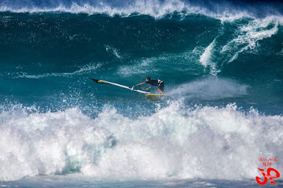
With the lighter more sideoff wind and some big waves, the afternoon at Hookipa was totally epic for the elite of windsurfers that could tackle the conditions. Below is Browsinho in a photo by Jimmie Hepp (check the whole gallery, there's plenty great shots!).


I instead caught the first wave since Nov 5th at thousand peaks (fun knee to waist high). Felt good to be in the water, felt not so good to see that I'm still far from 100% recovered, but that I knew already.
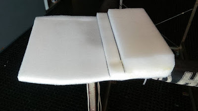
The best setup was on a longboard with this piece of foam I built (thanks blog reader Cathy for the original idea that I elaborated and customized) inside my wetsuit top on a longboard.

I will have to take a selfie with it on, because it looks like I have the biggest, squarest boobs you can think of and I get some looks that are quite interesting. Good lineup chat line, that's for sure.
The idea is to move the pressure from the lowest ribs (where my damage is) to the ones just above when laying down and paddling and it works quite well on a longboard.

It doesn't work on a shortboard, since it pushes the nose down too much (I actually added three more layers of foam in the final version).
Standup was fine for catching a wave, but once on a wave if I wanted to push my turns I had to use the paddle heavily and I felt that a bit. So I started to ride more mellow, but riding mellow on a sup felt quite boring, really.

So I'll stick to longboarding on small waves on the south shore.


We are in the beginning phase of a weather change that is beautifully - as usual - summarized by Pat Caldwell:
After an extended period with jet stream troughs west of the dateline and ridges to the east, which led to below average local surf from WNW to N and above average local trades and easterly windswell, a regime change began 12/26. A large upper level low pressure is being established over the north central Pacific and Bering Sea with the primary jet stream track at a southerly position in a mostly zonal, or west to east, pattern from near Japan to the longitudes of Hawaii. This is leading to a flip flop for local surf and wind, with above average WNW to N surf and below average trades and trade windswell in the upcoming period.

Buoys 6am.
NW
5.8ft @ 10s from 90° (E)
4.1ft @ 13s from 235° (WSW)

Waimea
3.4ft @ 12s from 331° (NNW)
3ft @ 14s from 336° (NNW)
2.5ft @ 9s from 22° (NNE)

Pauwela
6ft @ 10s from 78° (ENE)
4.5ft @ 14s from 335° (NNW)

Barbers
3.1ft @ 13s from 199° (SSW)
1.6ft @ 10s from 217° (SW)
 
As the Pauwela graph shows below, yesterday's big episode is quickly going down. 4.5f 14s is still a hell lot of fun, specially with the lack of wind, but that is going to decline all day. Don't forget the windswell.
A new WNW pulse is forecasted to fill in later today, but the reading at the NW buoy is from WSW and I'm not even going to try to understand that. No idea why.What I know is that we won't get much from that direction.
 
Barbers shows 3f 13s and I might have to go chase whatever is leftover on the south shore before it temporarily goes flat again.


Wind map shows a wide NW fetch and a windswell east one. Inside the NW fetch I outlined two blue areas that will give life to completely different waves in terms of size, period and direction. Inside the more intense blue sub-fetch I outlined two black areas that will give life to - once again - different waves.

That is to try to explain that, even if the Surfline buoys try to give you the breakdown of the different swells in the water (and that is great), inside a single swell that you might observe at the buoys, there's always components of different size, period and direction.

Most surfers are familiar with sets of different size, but there's also plenty variety in period and direction.
I'm sure most of you have observed sets coming more from the west or from the north at Hookipa...
The world of wave prediction has very little black and white situations. It's more like fifty shades of grey. Of blue, actually.

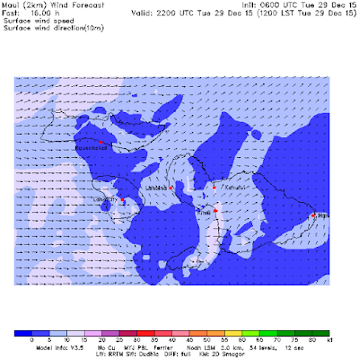
Notice also how the Hawaiian islands are in the middle of a small area of no wind. The area is small, so the lack of wind won't last long and tomorrow a NE breeze is already forecast to blow.
Get them today is my strong recommendation.


MC2km map at noon shows the pause in the wind I was talking about.

Monday, December 28, 2015

12 28 15 morning call

Yesterday I had to get out of the wind/rain again and went Makena side.

The south swell was showing, but the shape was bad because of the chop induced by the wind wrapping the whole kihei coast. Strong trades screw up the surf not only on the north shore.


Skimboarding at Big Beach looked more fun.


Meanwhile, the windsurfing action at Hookipa was pretty rad. This is Morgan Noireaux in a photo by Jimmie Hepp that shows well the remarkable size of the waves.


The three buoys graph at 5am is below. Notice the increase of the period that happened during the night at Waimea and Pauwela (bit harder to detect it on the NW graph, but it's there).
Waimea reads 9.7ft @ 17s from 335° (NNW) which is a pretty serious size. I'll be curious to check the Pipeline webcam later.

Pauwela reads 6.1ft @ 16s from 335° (NNW), but also 7.0ft @ 9s from 64° (ENE) of windswell that will heavily affect the ground swell waves. Overall, with these readings, I'm calling for bigger waves than yesterday. At least in the morning.


Below is the Barbers graph which is really hard to read. Not a good day for the Surfline buoy graphs, but in this case a reading of 4.8ft @ 14s from 260° (W) can only be justified by the NW energy wrapping around and hitting the buoy together with the south swell.

Definitely hard trying to gauge how big the south swell is. Yesterday mid day the readings were around 4.5f 15s from SSW (see that orange section between 6am and noon?), but the energy in the water in Maui was MUCH less than that, so I think that was influenced by the NW wrap too.


The buoys are confusing? Check the webcams! Here's the Lahaina one at 7am and it shows knee to waist high. But always check it yourself if you're thinking about going.


Wind map shows:
- a large NW fetch (no shortage of waves this week)
- a windswell fetch
- a weak south fetch


The wind should be less strong today and coming from an easterly direction, and that's also what the MC2km map at noon shows.

Sunday, December 27, 2015

12 27 15 morning call

I took this photo at sunset at Hookipa just to show the size. It looked like pure windswell to me.


I had an epic swim with an unexpected outrageous current. I thought lower tide would mean less current, but the full moon and a low tide in about three hours, made for a strong pull of water out of the bay through the channel between middles and pavils.
It usually takes me 10 minutes to swim from the point to pavils and 12 to come back. Yesterday it took me 9 and 16.

And after this incredibly uninteresting information, here's a shot of local grom Jackson Bunch with a beautiful tropical background. Photo by OneMore Foto probably from last Friday.


Below the graph of the three buoys. The NW swell at the NW buoys peaked around 9f 12s at 6pm yesterday and it's on its way up at both Waimea and Pauwela. I expect the peak to happen in Maui in the afternoon.


Let's not forget the south swell. Below is Barbers' graph. the 3am reading was 2.6ft @ 16s from 185° (S) and notice how relatively quickly it went up yesterday (light blue line). South swells usually take much longer to rise. Still, it's a south swell, so expect long lulls between sets and check the Lahaina webcam before going.


MC2km map at noon shows the wind that it shows. Should be the last day of strong wind.

Saturday, December 26, 2015

12 26 15 morning call

Very average conditions on the north shore yesterday due to a sideon wind that wasn't really good for anything.

Pretty flat on the south shore, but judging from this photo of Teahupoo from Ben Thouard taken on the 23rd, things should change soon. That's the south swell coming from those fetches I pointed out a week ago. Unfortunately, it won't be quite as big over here, but it's good to see that there's some energy travelling our way. No long period readings at the buoys yet, there should be some tomorrow.


Buoys 6am
NW
7.6ft @ 8s from 11° (NNE)
6.4ft @ 11s from 336° (NNW)

N
5.6ft @ 10s from 103° (ESE)
4.6ft @ 6s from 78° (ENE)
2.7ft @ 12s from 322° (NW)

Waimea
5.2ft @ 7s from 42° (NE)
2.4ft @ 9s from 16° (NNE)
2.3ft @ 11s from 329° (NW)

Pauwela
7.2ft @ 8s from 67° (ENE)           
3.6ft @ 7s from 53° (ENE)
 
Unfortunately the graph of the NW buoy is really hard to read and I can't tell you exactly when those 6f 11s from 336 will get here, but it will be sometimes in the afternoon today. Could be early or late. For the moment, only windswell again at the Maui buoy.
Wind map shows a wide "patchy" NW fetch, a small windswell one and another out of season south one.


MC2km map at noon shows the wind that it shows.

Friday, December 25, 2015

12 25 15 morning call

Hookipa at sunset looked fun with a mix of northwesterly sets (like the one in the photo) and windswell wrap.


Armpit sun.


Buoys 5am
NW
6.2ft @ 10s from 87° (E)

N
6.1ft @ 10s from 108° (ESE)
5.2ft @ 12s from 308° (WNW)

Waimea
4.1ft @ 13s from 322° (NW)
2.5ft @ 5s from 39° (NE)
1.7ft @ 9s from 339° (NNW)
1.5ft @ 11s from 332° (NNW)

Pauwela
8ft @ 11s from 73° (ENE)           
3.9ft @ 7s from 72° (ENE)
 
Very confusing readings today. NW energy going down at the NW buoy, up at the N buoy, steady at Waimea and gone at Pauwela.
Based on the fetches of 3-4 days ago, there should be some energy out of that direction, but I would focus on chasing the windswell. I don't even know if you can call it windswell anymore at 8f 11s!
Easterly expusures gonna be pumping. Too bad the wind will be on it.
 
Wind map shows still a strong fetch NNW of us, a new small and weak WNW one and the usual windswell one.


No updated mc2km maps today, but the wind is already blowing 14mph at Hookipa. Three more days of strong wind you guys. Hang in there.

Thursday, December 24, 2015

12 24 15 morning call

What a beautiful day yesterday was with sunshine, clean air and regular strength trades (not that craziness of the past few days). Still strong enough for the windsurfers to enjoy a Hookipa that looked very fun. The photos below are of the guy that IMO  has been the best free sailor in the last few years: Levi Siver.

I threw this one on Facebook in the evening and multiple times world champion Kevin Pritchard commented:"he is sailing amazing at the moment.."


He does everything to perfection, but, once again IMO, this is the part where he's better than everyone else: the exit from the bottom turn and transition to the top turn.
The radius he achieves is so tight that he must be putting a hell lot of pressure on the back foot. Yet he manages to use the whole rail of the board and gain speed all the way through the turn and then explode off the top like in the photo above.
A real pleasure to watch.


And that was just the power sailing part. As you can see from the next two shots, he's also very acrobatic above the lip, but that's a place where there's a bunch of other sailors that are just as good.


Amongst them is a 14 yo kid that is coming up real strong: Jake Schettewi in a photo from Jimmie Hepp.


Waves have been below the winter average for a week or so and Pat Caldwell explains why:
A jet stream block east of the dateline has kept surface low pressure systems a long way from Hawaii. The systems have been mostly gale, less than winter-caliber, thus the weaker magnitude and long travel distance has meant small surf for Hawaii this week from within WNW to N.
 

Yesterday was one of those "small" NW episodes (it's all relative), and today there should be another one as the graph of the NW buoy below seem to confirm.
I put red arrows to show when the swell went from 3 to 5 feet.


NW
5.5ft @ 10s from 81° (E)
5.1ft @ 12s from 322° (NW)
           
Waimea
2.4ft @ 7s from 41° (NE)           
2ft @ 9s from 22° (NNE)
1.7ft @ 14s from 310° (WNW)
1.6ft @ 11s from 333° (NNW)

Pauwela
7.2ft @ 10s from 88° (E)

So only elevated windswell for the moment in Maui, but the NW energy should show up in the afternoon.

 
Wind map shows a fairly big NW fetch and the usual windswell one. That's as good as that NW fetch is going to get and the peak of related swell id forecasted by Surfline for Monday night (9f 16s).
Unfortunately it will coincide with yet another strong trades windswell episode.

In fact, the associated front will fail to get closer to the islands and kill the wind. I put a blue circle on the area of light wind between the front and the trades generating high pressure, but unfortunately that won't get on top of us. Not until next year, at least.
I know, this is not an impartial forecast. It's a forecast full of opinions and preferences.

The good news is that that big cloudy area also didn't move on top of us, so today should be another gorgeous sunny day.


MC2km map at noon below shows the wind that it shows, but the time stamp up in the right corner says dec 23 yet the maps start from the 24, so I'm not 100% sure that is an updated map or not.
Either way, here at my house in Kuau looks like no wind at 7am, go get those glassy waves until they last....


Wednesday, December 23, 2015

12 23 15 morning call

Still fun waves at Hookipa yesterday.

This is Kevin Pritchard in a photo by Jimmie Hepp.


Not sure when it was taken, but this "heavy Tahitian slab" was just posted by photographer Ben Thouard. Could be used as a definition of hollow.


Buoys 3am
NW
8.5ft @ 10s from 94° (E)
2.7ft @ 4s from 104° (ESE)

Waimea
4.5ft @ 8s from 37° (NE)
2.9ft @ 14s from 330° (NW)

Pauwela
5.5ft @ 10s from 84° (E)
4.5ft @ 7s from 66° (ENE)
2.7ft @ 14s from 332° (NNW)
2.7ft @ 12s from 341° (NNW)
 
Windswell trending down at the Pauwela buoy (dark blue line) and the NW energy (light blue line) should start fading too. Far from flat, but smaller than last couple of days.

Wind map shows a large NW fetch and the windswell one that is getting a tiny bit weaker.


Mc2km map at non show a lot less wind than the past... weeks!


For quite a long time, I lived right next door to the Meola family. From my studio I could hear Lily practicing her singing and that was a delight. Listening to her first cd brought me back to those years and since they were pretty good years, that put a smile on my face.
We have it for sale at Hi-Tech. This is Lily's website.