6.5
Friday, January 31, 2020
Friday 1 31 20 morning call
The second half of January continued to deliver excellent surfing conditions (this morning included). Surfline noticed and published this article (only for subscribers, I think) full of incredible photos and videos of epic waves.
These instead are the photos I took at Hookipa yesterday morning after my session.


4am significant buoy readings and discussion
South shore
Barbers
3.1ft @ 9s from 230° (SW)
Not sure what to make of that reading at Barbers, as usual the way to find out what's in the water on that side is to look at the Lahaina webcam (there were some waves yesterday and looks like there are also today).
North shore
NW001
11.6ft @ 12s from 337° (NNW)
Waimea
5.7ft @ 13s from 317° (NW)
Kahului Tides
High Tide High Tide Low Tide Low Tide Sunrise Sunset
5:48a +1.7 7:40p +1.2 1:00p +0.5 11:51p +1.1 7:05a 6:18p
North Pacific has the fetches circled in red. Notice how the close-by fetch that yesterday was NW of us literally raced across the great circle rays and is now in a NNE position.

Proper low (949mbar) in the South Pacific, the portion of the ocean with winds oriented towards us (that's the definition of a fetch) is rather small, but it should make for a small south swell in a week (1.6ft 16s from 197 predicted by Surfline on Friday)

Morning sky.

These instead are the photos I took at Hookipa yesterday morning after my session.


4am significant buoy readings and discussion
South shore
Barbers
3.1ft @ 9s from 230° (SW)
Not sure what to make of that reading at Barbers, as usual the way to find out what's in the water on that side is to look at the Lahaina webcam (there were some waves yesterday and looks like there are also today).
North shore
NW001
11.6ft @ 12s from 337° (NNW)
Waimea
5.7ft @ 13s from 317° (NW)
1.5ft @ 12s from 318° (NW)
Pauwela
Pauwela
5.7ft @ 10s from 72° (ENE)

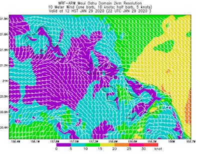
Wind map at noon

4.8ft @ 14s from 316° (NW)
2.3ft @ 6s from 89° (E)
Waimea is back, below are the graphs of NW and Pauwela together with the Surfline forecast. On the first one, I highlighted a first slow rise in size in yellow and a second sharper rise (with shorter period) in fuchsia. Notice also how the direction went more north during the second pulse. Locally the first rise should happen throughout the day, while the second one should start right around sunset. For once, the Surfline timing seems correct.
Waves at Hookipa should be overhead with clean conditions, I'll report from the beach later.

Wind map at noon

Kahului Tides
High Tide High Tide Low Tide Low Tide Sunrise Sunset
5:48a +1.7 7:40p +1.2 1:00p +0.5 11:51p +1.1 7:05a 6:18p
North Pacific has the fetches circled in red. Notice how the close-by fetch that yesterday was NW of us literally raced across the great circle rays and is now in a NNE position.

Proper low (949mbar) in the South Pacific, the portion of the ocean with winds oriented towards us (that's the definition of a fetch) is rather small, but it should make for a small south swell in a week (1.6ft 16s from 197 predicted by Surfline on Friday)

Morning sky.

Thursday, January 30, 2020
Thursday 1 30 20 morning call
Pretty good size waves yesterday, this is Hookipa at sunset.

4am significant buoy readings and discussion
South shore
No southerly energy at Barbers, little out of season south swell is over. There shouldn't be much, but check the Lahaina webcam if interested.
North shore
NW001
6.9ft @ 15s from 302° (WNW)
Kahului Tides
High Tide High Tide Low Tide Low Tide Sunrise Sunset
5:31a +1.9 6:05p +1.3 12:21p +0.5 11:14p +0.8 7:05a 6:17p
North Pacific has many scattered fetches, the most important of which is the one just to our NW which will send us a medium period swell (9ft 12s from 319 predicted by Surfline on Friday night).

South Pacific has a small fetch blocked by New Zealand.

Morning sky.


4am significant buoy readings and discussion
South shore
No southerly energy at Barbers, little out of season south swell is over. There shouldn't be much, but check the Lahaina webcam if interested.
North shore
NW001
6.9ft @ 15s from 302° (WNW)
5.8ft @ 10s from 309° (WNW)
Pauwela
5.6ft @ 14s from 317° (NW) Pauwela
4.2ft @ 10s from 347° (NNW)
3.6ft @ 11s from 322° (NW)
Yesterday's WNW peaked, but it will still offer plenty waves of slightly smaller size and different periods (read Pat Caldwell description of the sources, if interested), before a new reinforcement arrives tomorrow. Hookipa should be overhead, I will report from the beach around 7am. There should be no wind until around 11am.
Wind map at noon

Wind map at noon

Kahului Tides
High Tide High Tide Low Tide Low Tide Sunrise Sunset
5:31a +1.9 6:05p +1.3 12:21p +0.5 11:14p +0.8 7:05a 6:17p
North Pacific has many scattered fetches, the most important of which is the one just to our NW which will send us a medium period swell (9ft 12s from 319 predicted by Surfline on Friday night).

South Pacific has a small fetch blocked by New Zealand.

Morning sky.

Wednesday, January 29, 2020
Wednesday 1 29 20 morning call
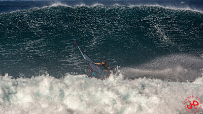
Buttery conditions yesterday morning at Hookipa, I took these shots after my session.


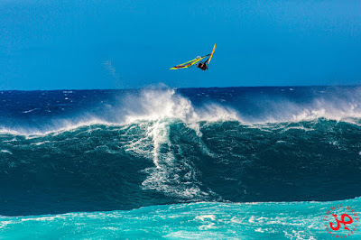
This is my pick of Jimmie Hepp's album of the windsurfing action. I guess the big sets kept pouring in all day.
6am significant buoy readings and discussion
South shore
No southerly energy at Barbers, the Lahaina webcam shows a little leftover energy from the south, but onshore conditions.
North shore
NW001
7.8ft @ 15s from 291° (WNW)
Waimea
N/A
Pauwela
4.8ft @ 14s from 319° (NW)
New NW swell on the rise all day, let's how Pat Cladwell described the evolution of the fetch:
The next low pressure in the series occluded on Saturday 1/25 within the parent Aleutian low filling the NW to central N Pacific. Winds were strongest 1/25 to severe gales, with an exceptionally long, broad fetch of gales covering within 25-45N and the Kuril Islands to the Date Line. The pattern is slowly weakening 1/27-28 with an eastward shift. Near gales have reached to within 1000 nm of Hawaii by 1/27. This pattern is expected to hold about the same into 1/29.
Surf is predicted to rebuild above average Tuesday night and continue to rise Wednesday from 290-320 degrees. Heights should hold at elevated levels on Thursday. The more WNW to NW surf generated within 1/25-29 should be long-lived in Hawaii, holding Friday into Sunday 1/31-2/2 with a slow downward trend. More NNW surf is due to dominate by mid Friday into Saturday 1/31-2/1.
Below is the collage of the maps of Jan 25, 26, 27 and 28.

Below are the graphs of NW001 and Pauwela together with the Surfline forecast. I circled in red the rise at the NW buoy, a similar rise should happen during the day locally. We start with 5ft, it might be up to 8ft by sunset. Hookipa should be overhead already in the morning, I will report later. Clean conditions with no wind until around noon.

The Volcom Pipe Pro starts at 8am, I don't see a link for the live stream on the WSL page, but it seems there should be one here. It should a cracker of a day, judging by this screen shot.
Wind map at noon
Kahului Tides
High Tide High Tide Low Tide Low Tide Sunrise Sunset
5:10a +2.1 5:07p +1.3 11:49a +0.6 10:44p +0.5 7:05a 6:16p
North Pacific has the fetches highlighted on the map.

Nothing from the south.

Morning sky.


This is my pick of Jimmie Hepp's album of the windsurfing action. I guess the big sets kept pouring in all day.

6am significant buoy readings and discussion
South shore
No southerly energy at Barbers, the Lahaina webcam shows a little leftover energy from the south, but onshore conditions.
North shore
NW001
7.8ft @ 15s from 291° (WNW)
3.9ft @ 12s from 294° (WNW)
3.8ft @ 10s from 301° (WNW)
Waimea
N/A
Pauwela
4.8ft @ 14s from 319° (NW)
3.8ft @ 9s from 74° (ENE)
3.8ft @ 7s from 73° (ENE)
1.6ft @ 12s from 323° (NW)
New NW swell on the rise all day, let's how Pat Cladwell described the evolution of the fetch:
The next low pressure in the series occluded on Saturday 1/25 within the parent Aleutian low filling the NW to central N Pacific. Winds were strongest 1/25 to severe gales, with an exceptionally long, broad fetch of gales covering within 25-45N and the Kuril Islands to the Date Line. The pattern is slowly weakening 1/27-28 with an eastward shift. Near gales have reached to within 1000 nm of Hawaii by 1/27. This pattern is expected to hold about the same into 1/29.
Surf is predicted to rebuild above average Tuesday night and continue to rise Wednesday from 290-320 degrees. Heights should hold at elevated levels on Thursday. The more WNW to NW surf generated within 1/25-29 should be long-lived in Hawaii, holding Friday into Sunday 1/31-2/2 with a slow downward trend. More NNW surf is due to dominate by mid Friday into Saturday 1/31-2/1.
Below is the collage of the maps of Jan 25, 26, 27 and 28.

Below are the graphs of NW001 and Pauwela together with the Surfline forecast. I circled in red the rise at the NW buoy, a similar rise should happen during the day locally. We start with 5ft, it might be up to 8ft by sunset. Hookipa should be overhead already in the morning, I will report later. Clean conditions with no wind until around noon.

The Volcom Pipe Pro starts at 8am, I don't see a link for the live stream on the WSL page, but it seems there should be one here. It should a cracker of a day, judging by this screen shot.

Wind map at noon

Kahului Tides
High Tide High Tide Low Tide Low Tide Sunrise Sunset
5:10a +2.1 5:07p +1.3 11:49a +0.6 10:44p +0.5 7:05a 6:16p
North Pacific has the fetches highlighted on the map.

Nothing from the south.

Morning sky.

Tuesday, January 28, 2020
Tuesday 1 28 20 morning call
This video with some amazing waves from Jan 23rd at Jaws just came out.
The first half of January has shown us how bad a winter in Hawaii can be. The second is showing us how good it can be. Waves every day, easterly trades that allow for clean surfing conditions in the morning and wind sports in the afternoon and then surfing again at sunset, with overall extremely pleasant weather and temperatures. And the best feels even better when experienced right after the worst!
This is my pick of Jimmie Hepp's album of yesterday's windsurfing action at Hookipa.

4am significant buoy readings and discussion
South shore
I heard there were waves on the Lahaina side yesterday, I was too busy between sessions on the north shore to even check out the webcam, please do so if you're interested to see what's there.
North shore
NW001
5.9ft @ 12s from 303° (WNW)

Wind map at noon

Kahului Tides
High Tide High Tide Low Tide Low Tide Sunrise Sunset
4:47a +2.3 4:22p +1.3 11:20a +0.6 10:14p +0.2 7:05a 6:16p
North Pacific has a NW, a tiny N and a windswell fetch.

Nothing from the south.

Morning sky.

The first half of January has shown us how bad a winter in Hawaii can be. The second is showing us how good it can be. Waves every day, easterly trades that allow for clean surfing conditions in the morning and wind sports in the afternoon and then surfing again at sunset, with overall extremely pleasant weather and temperatures. And the best feels even better when experienced right after the worst!
This is my pick of Jimmie Hepp's album of yesterday's windsurfing action at Hookipa.

4am significant buoy readings and discussion
South shore
I heard there were waves on the Lahaina side yesterday, I was too busy between sessions on the north shore to even check out the webcam, please do so if you're interested to see what's there.
North shore
NW001
5.9ft @ 12s from 303° (WNW)
2.9ft @ 10s from 309° (WNW)
Waimea
5.5ft @ 14s from 322° (NW)
Waimea
5.5ft @ 14s from 322° (NW)
2.8ft @ 10s from 323° (NW)
Pauwela
Pauwela
4.8ft @ 14s from 330° (NW)
3.5ft @ 9s from 62° (ENE)
3.3ft @ 12s from 330° (NW)
3.2ft @ 7s from 74° (ENE)
The NW swell remained at a pretty steady 7ft 14s all day yesterday (that is unusual), but right after sunset, it went down quite a bit, as shown in the Pauwela graph below (orange line). It should continue to slowly decline all day. With a 4am reading of almost 5ft 14s, fun still overhead waves should be on offer at Hookipa (smaller down the coast and on the west side) with good wind conditions in the early morning. I will report from the beach later.

Wind map at noon

Kahului Tides
High Tide High Tide Low Tide Low Tide Sunrise Sunset
4:47a +2.3 4:22p +1.3 11:20a +0.6 10:14p +0.2 7:05a 6:16p
North Pacific has a NW, a tiny N and a windswell fetch.

Nothing from the south.

Morning sky.

Monday, January 27, 2020
Monday 1 27 20 morning call
FishBowlDiaries posted the windsurfing shots of Jaws from two days ago in this album. This is Browsinho in a ballsy aerial off the thick lip.

But, as predicted, there were plenty big waves to play with also yesterday. Hookipa was occasionally double mast, I picked this one from this album by Jimmie Hepp.
4am significant buoy readings and discussion
South shore
No southerly energy at Barbers, but it might be masked under the NW one. This week might have small waves from the south, as the collection of the maps from Jan 20 to 24 shows below. Checking the Lahaina webcam is the only way to find out without going there.

North shore
NW001
10ft @ 13s from 319° (NW)
Waimea
Kahului Tides
High Tide High Tide Low Tide Low Tide Sunrise Sunset
4:21a +2.5 3:43p +1.3 10:53a +0.6 9:43p 0.0 7:06a 6:15p
NW fetches continue to populate the western Pacific, no complains about that.

Micro fetch down south (too small for anything at all).

Morning sky.


But, as predicted, there were plenty big waves to play with also yesterday. Hookipa was occasionally double mast, I picked this one from this album by Jimmie Hepp.

4am significant buoy readings and discussion
South shore
No southerly energy at Barbers, but it might be masked under the NW one. This week might have small waves from the south, as the collection of the maps from Jan 20 to 24 shows below. Checking the Lahaina webcam is the only way to find out without going there.

North shore
NW001
10ft @ 13s from 319° (NW)
Waimea
6.9ft @ 14s from 323° (NW)
2.7ft @ 13s from 325° (NW)
2.4ft @ 10s from 332° (NNW)
Pauwela
6.9ft @ 15s from 324° (NW)

Wind map at noon

Pauwela
6.9ft @ 15s from 324° (NW)
4.2ft @ 12s from 325° (NW)
NW swell holding up nicely. Below is the graph of NW001 and Pauwela, together with the Surfline forecast, which sees the swell slowly declining in the next couple of days. The decline of the size of the breaking waves will be due mostly to the decline in period. As confusing as that may sound, 7ft 15 make for bigger waves than 7ft 14, which is bigger than 7ft 13s and so on. The size is not the only thing that changes, also the power and overall hollowness goes down when the period declines.
That said, Hookipa will still have plenty size for the experts only (possibly still occasionally up to double overhead), while more protected spots down the coast will be smaller. Great wind (or lack of thereof) all morning till noon.

Wind map at noon

Kahului Tides
High Tide High Tide Low Tide Low Tide Sunrise Sunset
4:21a +2.5 3:43p +1.3 10:53a +0.6 9:43p 0.0 7:06a 6:15p
NW fetches continue to populate the western Pacific, no complains about that.

Micro fetch down south (too small for anything at all).

Morning sky.

Sunday, January 26, 2020
Sunday 1 26 20 morning call
Thanks to blog reader Jan for his donation.
As I reported from the beach twice, yesterday morning the waves at Hookipa came up earlier than I expected. Fortunately I managed to squeeze a sesh in before it got too big for my taste. After which, I took some pics: this is Middles.

This is Matt Meola ripping at Lanes. The waves were beautifully peeling down the line and he couldn't find a ramp for his aerials. Here's a quit chat we had when he got out of the water:
"Hey Matt, no ramps for you today?"
"Nah, too soft"
"Does that mean you don't enjoy doing turns anymore?"
"Oh, I like doing turns, but on steeper sections! It was too mushy out there."
I got out of the water because it was getting too big and he found it too soft and mushy... it's all relative I guess, the skill gap is ample.

If some of Jimmie Hepp's subscribers complained about him not being at Hookipa, I take the full blame as I texted him that Hookipa was going to get too big for windsurfing (someone did sail out eventually) and instead sent him to Honolua to shoot the Legends of the Bay contest, which was won by a ripping Ian Gentil. This is my pick of Jimmie's album.
Honolua's shadow line sits at 335, the swell was from around 315, amazing how long period swells wrap around lands.

There was action everywhere, this Zach Schettewi at Jaws. Photo by FishBowlDiaries. They're editing the windsurfing shots, stay tuned tomorrow.

4am significant buoy readings and discussion
South shore
No southerly energy at Barbers, check the Lahaina webcam. There's some small, kinda useless wrap from the NW swell. That's a good sign for the second day of the contest at the Bay, which today will see all the remaining categories (other than Open Men).

North shore
NW001
11.3ft @ 16s from 314° (NW)
Waimea
13.1ft @ 17s from 319° (NW)
Pauwela
11.1ft @ 17s from 318° (NW)
Below is the graph of NW and Pauwela together with yesterday's Surfline forecast. You can see how the swell picked locally in the mid morning, much earlier than the Surfline forecast and even earlier than my guessed red dotted line. On the NW graph you can notice how it's staying at elevated levels of size, just slowly comind down a second or two in the period. That means another full day of big waves for Maui's north shore. Hookipa too big for the common mortals, seek sheltered/shadowed spots, if you're one of them.

Wind map at noon

Kahului Tides
High Tide High Tide Low Tide Low Tide Sunrise Sunset
3:55a +2.6 3:06p +1.3 10:27a +0.6 9:12p -0.2 7:06a 6:14p
North Pacific has another long NW fetch. Next swell is predicted by Surfline to peak at 9ft 15s from 309, but there will be no shortage of waves in the meantime.

Nothing from the south.

Morning sky.

Saturday, January 25, 2020
Saturday 1 25 20 morning call
Thanks to blog reader Jeff for his donation.
This is Billy Kemper's incredible barrel at Jaws two days ago. A ride that will earn him some price money of some sort, for sure.
Hookipa had good size waves during the day yesterday, this is my pick of Jimmie Hepp's album.

I took this one at sunset. Conditions weren't particularly clean because of the light onshore that picked up in the afternoon.

4am significant buoy readings and discussion
South shore
No southerly energy at Barbers, check the Lahaina webcam.
North shore
NW001
14.3ft @ 17s from 324° (NW)
Waimea
5.5ft @ 12s from 320° (NW)
New long period XL swell on the rise all day today, while the previous one is on the decline with still almost 5ft 13s at 4am. Plenty waves on offer, Hookipa will be surfable in the morning (still overhead) and possibly getting too big (and windy) to surf in the afternoon, but might epic windsurfing for the pros. Let's see how Pat Caldwell describes the evolution of the fetch:
Another winter-caliber low pressure formed east of the Kuril Islands 1/20 and deepened to storm- to hurricane-force winds well west of the Date Line 1/21-22. The system occluded 1/22 as it stalled near the Date Line. A long, wide fetch from Asia to within 1200 nm of Hawaii set up 1/22-23 centered within 310-320 degrees. Gales also covered the 290-310 and 320-330 degree bands. The result will be another round with a wide swell directional swath arriving in Hawaii. The low centered weakened and moved westward near 50N west of the Date Line 1/24.
JASON satellite 1/23 showed seas within 22-27' about 1000 nm away from Hawaii. The ASCAT satellite showed a wide fetch of near gales to low end gales 1/22-23 with 30-40N from the Date Line east to north of Hawaii, that should add ample short- to moderate period surf over the weekend.
The end result is going to be a wide wave period band, or broad- banded spectral energy for the upcoming event 1/25, with active waves in the 12-20s bands arriving simultaneously. In addition to the wide directional spread, should make for less regular breaking patterns.
Below is the collage of the maps of Jan 21, 22, 23 and 24.

These are the graphs of NW001 and Pauwela together with the Surfline forecast, which, once again, seems to be a bit late. The best waves at the Legend of the Bay contest will be in the late afternoon, just in time for the open men final. The morning should be fairly small, with mostly the leftover of the previous swell.

Wind map at noon. It will get windier after that and this marks the end of those fabulous 4 days of light wind we just had. Jan 23 best day of the year so far without a doubt.

Kahului Tides
High Tide High Tide Low Tide Low Tide Sunrise Sunset
3:27a +2.7 2:29p +1.3 10:01a +0.6 8:39p -0.4 7:06a 6:14p
North Pacific has a new WNW fetch. 8.7ft 15s from 311 predicted by Surfline on Wednesday night.

Tino's remnants not offering much anymore.

Morning sky.

This is Billy Kemper's incredible barrel at Jaws two days ago. A ride that will earn him some price money of some sort, for sure.
Hookipa had good size waves during the day yesterday, this is my pick of Jimmie Hepp's album.

I took this one at sunset. Conditions weren't particularly clean because of the light onshore that picked up in the afternoon.

4am significant buoy readings and discussion
South shore
No southerly energy at Barbers, check the Lahaina webcam.
North shore
NW001
14.3ft @ 17s from 324° (NW)
4.3ft @ 10s from 326° (NW)
Waimea
5.5ft @ 12s from 320° (NW)
2.7ft @ 20s from 313° (NW)
Pauwela
Pauwela
4.9ft @ 13s from 323° (NW)
2.6ft @ 9s from 346° (NNW)
2.3ft @ 11s from 329° (NW)
1.1ft @ 22s from 311° (NW)
New long period XL swell on the rise all day today, while the previous one is on the decline with still almost 5ft 13s at 4am. Plenty waves on offer, Hookipa will be surfable in the morning (still overhead) and possibly getting too big (and windy) to surf in the afternoon, but might epic windsurfing for the pros. Let's see how Pat Caldwell describes the evolution of the fetch:
Another winter-caliber low pressure formed east of the Kuril Islands 1/20 and deepened to storm- to hurricane-force winds well west of the Date Line 1/21-22. The system occluded 1/22 as it stalled near the Date Line. A long, wide fetch from Asia to within 1200 nm of Hawaii set up 1/22-23 centered within 310-320 degrees. Gales also covered the 290-310 and 320-330 degree bands. The result will be another round with a wide swell directional swath arriving in Hawaii. The low centered weakened and moved westward near 50N west of the Date Line 1/24.
JASON satellite 1/23 showed seas within 22-27' about 1000 nm away from Hawaii. The ASCAT satellite showed a wide fetch of near gales to low end gales 1/22-23 with 30-40N from the Date Line east to north of Hawaii, that should add ample short- to moderate period surf over the weekend.
The end result is going to be a wide wave period band, or broad- banded spectral energy for the upcoming event 1/25, with active waves in the 12-20s bands arriving simultaneously. In addition to the wide directional spread, should make for less regular breaking patterns.
Below is the collage of the maps of Jan 21, 22, 23 and 24.

These are the graphs of NW001 and Pauwela together with the Surfline forecast, which, once again, seems to be a bit late. The best waves at the Legend of the Bay contest will be in the late afternoon, just in time for the open men final. The morning should be fairly small, with mostly the leftover of the previous swell.

Wind map at noon. It will get windier after that and this marks the end of those fabulous 4 days of light wind we just had. Jan 23 best day of the year so far without a doubt.

Kahului Tides
High Tide High Tide Low Tide Low Tide Sunrise Sunset
3:27a +2.7 2:29p +1.3 10:01a +0.6 8:39p -0.4 7:06a 6:14p
North Pacific has a new WNW fetch. 8.7ft 15s from 311 predicted by Surfline on Wednesday night.

Tino's remnants not offering much anymore.

Morning sky.

Subscribe to:
Posts (Atom)


