1.5
Saturday, November 30, 2019
Saturday 11 30 19 morning call
Big thanks to blog reader Osh for his donation.
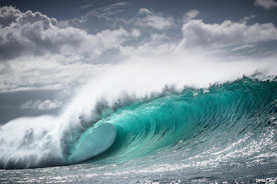
This is a photo of Hookipa yesterday morning. classic bumps, ribs and overall poor shape. Hard to test a board there if the opportunities of doing something good are so limited.

4am significant buoy readings and discussion.
South shore
Lanai
1ft @ 13s from 206° (SSW)

Check the Lahaina webcam for today's size and conditions. Unfortunately it's heavily stuttering today, but I was able to capture this small clean line.

North shore
NW001
10.4ft @ 10s from 66° (ENE)
Waimea
4.2ft @ 8s from 13° (NNE)
Kahului Tides
High Tide High Tide Low Tide Low Tide Sunrise Sunset
5:21a +2.5 3:17p +1.1 12:39p +1.0 10:01p +0.1 6:47a 5:45p
North Pacific has the circled fetches in the picture. The fetch of the N swell is now entirely aiming east of us, we only have that NE one close by, which will only add short period disturbances to the long period energy that is on its way (should be, at least). Based on this observation, I'm going to predict again that this long period N swell is not going to be particularly long lasting, despite the fact that yesterday afternoon I read Pat Caldwell saying the opposite. Unfortunately, this morning that page (link n.9) is not available (Geoff, I might need your investigation here), let's hope it comes back up soon.
Oh, if you were wondering why the NW buoy is reading 10ft 10s from ENE, I put a little red X to indicate its position... which explains the reading, as it's right in the middle of the active seas. We are going to be exposed to NE energy too and that is the one that is going to be long lasting.
To recap:
- long period N energy will last mostly Sunday/Monday and then decline noticeably on Tuesday
- shorter period NE energy should stick around all next week instead.
Nothing from the south.

Morning sky.

This is a photo of Hookipa yesterday morning. classic bumps, ribs and overall poor shape. Hard to test a board there if the opportunities of doing something good are so limited.

4am significant buoy readings and discussion.
South shore
Lanai
1ft @ 13s from 206° (SSW)
0.3ft @ 20s from 195° (SSW)
1ft 13s might make for some small waves (although the fact that is not recorded by Barbers is not encouraging), but what's even better is the 0.3ft 20s reading. Below are the maps of Nov 23 and 24, that show the fetch that generated a swell that should bring a little long period off season south swell, which should be better filled in tomorrow. Btw, Sunday/Monday the Lahaina area could have waves both from the south and from the N wrap.

Check the Lahaina webcam for today's size and conditions. Unfortunately it's heavily stuttering today, but I was able to capture this small clean line.

North shore
NW001
Waimea
4.2ft @ 8s from 13° (NNE)
3.5ft @ 7s from 33° (NE)
1.8ft @ 13s from 354° (N)
Pauwela
Pauwela
4.8ft @ 6s from 78° (ENE)
4.8ft @ 9s from 52° (ENE)
2.3ft @ 13s from 5° (N)
The last two swells on the Pauwela list are going to be the ones that will characterize the waves on the north shore today (Hookipa should be at least head high). Actually, what it will unfortunately characterize them even more is the strong wind. Expect blown out conditions all day, unless you're lucky/patient enough to catch an after squall temporary break.
Btw, the big N swell is only tomorrow for Maui.
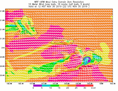
Wind map at noon.
Btw, the big N swell is only tomorrow for Maui.
Wind map at noon.

Kahului Tides
High Tide High Tide Low Tide Low Tide Sunrise Sunset
5:21a +2.5 3:17p +1.1 12:39p +1.0 10:01p +0.1 6:47a 5:45p
North Pacific has the circled fetches in the picture. The fetch of the N swell is now entirely aiming east of us, we only have that NE one close by, which will only add short period disturbances to the long period energy that is on its way (should be, at least). Based on this observation, I'm going to predict again that this long period N swell is not going to be particularly long lasting, despite the fact that yesterday afternoon I read Pat Caldwell saying the opposite. Unfortunately, this morning that page (link n.9) is not available (Geoff, I might need your investigation here), let's hope it comes back up soon.
Oh, if you were wondering why the NW buoy is reading 10ft 10s from ENE, I put a little red X to indicate its position... which explains the reading, as it's right in the middle of the active seas. We are going to be exposed to NE energy too and that is the one that is going to be long lasting.
To recap:
- long period N energy will last mostly Sunday/Monday and then decline noticeably on Tuesday
- shorter period NE energy should stick around all next week instead.

Nothing from the south.

Morning sky.

Friday, November 29, 2019
Friday 11 29 19 morning call
You always need another board, don't you? This is the unpacking of my latest purchase. I rarely go for a custom, most times I grab boards off the rack or used. This one was a bit of a act of faith, as I've never seen this particular model until... yesterday morning.
This is the link to one of the promo video I mention. I grabbed this frame of Kekoa Bacalso. That's exactly the type of waves I ordered it for and the type of turns I'd like to (try to) do.

This wave instead is the exact opposite. Fun, but small and crumbling, that's where you can take advantage of a wider tail that keeps planing in the soft sections. I caught a few waves there and felt that the board needed more juice underneath. That was what I expected.

Perfect for the littlest of the Brown groms instead. The involuntary frame was provided by a tree branch.

Hookipa looked really fun for windsurfing, but I was in new board testing mode and I waited until the wind would let go a bit...

...which it never completely did, so I decided to pass. Gonna be real windy the next couple of days, the test might have to wait... or I need to go to Oahu!

5am significant buoy readings and discussion.
South shore
No southerly energy at the buoys, the Lahaina webcam looks pretty flat.
North shore
NW101
10.4ft @ 8s from 45° (NE)
Waimea
3.5ft @ 10s from 359° (N)

Kahului Tides
High Tide High Tide Low Tide Low Tide Sunrise Sunset
4:37a +2.7 2:55p +1.2 11:27a +1.0 9:31p -0.2 6:46a 5:45p
North Pacific has several small scattered fetches and the big and strong N one now aiming to our east, so I circled it in blue and we should get some angular spreading out of it. That's the end of the generation of the Honolua swell for the contest, they might have to condense everything in two days (most likely Sunday/Monday).

Tiny fetch in the South Pacific, won't do much.

Morning sky.

This is the link to one of the promo video I mention. I grabbed this frame of Kekoa Bacalso. That's exactly the type of waves I ordered it for and the type of turns I'd like to (try to) do.

This wave instead is the exact opposite. Fun, but small and crumbling, that's where you can take advantage of a wider tail that keeps planing in the soft sections. I caught a few waves there and felt that the board needed more juice underneath. That was what I expected.

Perfect for the littlest of the Brown groms instead. The involuntary frame was provided by a tree branch.

Hookipa looked really fun for windsurfing, but I was in new board testing mode and I waited until the wind would let go a bit...

...which it never completely did, so I decided to pass. Gonna be real windy the next couple of days, the test might have to wait... or I need to go to Oahu!

5am significant buoy readings and discussion.
South shore
No southerly energy at the buoys, the Lahaina webcam looks pretty flat.
North shore
NW101
10.4ft @ 8s from 45° (NE)
Waimea
3.5ft @ 10s from 359° (N)
3.2ft @ 11s from 319° (NW)
Pauwela
Pauwela
4.5ft @ 10s from 31° (NE)
3.3ft @ 11s from 349° (NNW)
3ft @ 6s from 80° (E)
0.8ft @ 15s from 28° (NNE)
15s reading at Pauwela is probably a glitch, what we have today is 3.3ft 11s of leftover inconsistent declining angular spreading NW energy and "only" 4.5ft 10s from easterly windswell. Imo, the directions are all influencing each other, in reality, based on the position of the fetches, the NW is more west and the E is more east than what it shows. One possible explanation of why this NW "underperformed" is that the strong E swell cancelled part of its energy. My observations of swells crossing each other from different directions is mostly altered shape of the waves while breaking (a daily occurrence at Hookipa). I don't believe much into the weakening effect, but sure, that would be a possible explanation. I still believe it was the angular spreading instead.
Hookipa probably head high, not much on the rest of the north shore, eastern exposures will have waves instead.
Wind map at noon.
Hookipa probably head high, not much on the rest of the north shore, eastern exposures will have waves instead.
Wind map at noon.

Kahului Tides
High Tide High Tide Low Tide Low Tide Sunrise Sunset
4:37a +2.7 2:55p +1.2 11:27a +1.0 9:31p -0.2 6:46a 5:45p
North Pacific has several small scattered fetches and the big and strong N one now aiming to our east, so I circled it in blue and we should get some angular spreading out of it. That's the end of the generation of the Honolua swell for the contest, they might have to condense everything in two days (most likely Sunday/Monday).

Tiny fetch in the South Pacific, won't do much.

Morning sky.

Thursday, November 28, 2019
Thursday 11 28 19 morning call
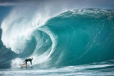
Lots of westerly swells these days, here's another beautiful shot of the very photogenic Pipeline by Liquid Barrel.
5am significant buoy readings and discussion.
South shore
No indication of southerly energy at the buoys, and the Lahaina webcam reflects that. Yesterday instead there were actually waist high plus waves (no idea where from). Always worth a check.
North shore
Waimea
3.6ft @ 13s from 314° (NW)

Kahului Tides
High Tide High Tide Low Tide Low Tide Sunrise Sunset
3:56a +2.8 2:30p +1.4 10:30a +0.9 9:01p -0.3 6:46a 5:45p
In the NW corner there's a weak fetch out of which we should get some angular spreading in about four days,, but to the North of us is the much stronger one that will send the waves for the first contestable day at Honolua. The high I marked will move to the east and take over the middle of the Pacific.

That will be the start of a long period of trades that will last until the jet stream will finally have a dip into the Pacific that will bring to the formation of the monster low we see in the map of Dec 7th. Long term forecasts are subject to change, but that should provide the Pipe Masters (Dec 8 to 20) with a solid swell, hopefully not too big.

Nothing from the south.

Morning sky.


5am significant buoy readings and discussion.
South shore
No indication of southerly energy at the buoys, and the Lahaina webcam reflects that. Yesterday instead there were actually waist high plus waves (no idea where from). Always worth a check.
North shore
Waimea
3.6ft @ 13s from 314° (NW)
3.3ft @ 11s from 317° (NW)
Pauwela
Pauwela
5.8ft @ 10s from 52° (ENE)
5ft @ 13s from 316° (NW)
2.9ft @ 6s from 71° (ENE)
The north shore will definitely be pumping in the afternoon, I wrote yesterday. Well, it wasn't. Below is the graph of Pauwela that shows (light blue line) that the swell did pick up (at the buoy) pretty much as I predicted with the red dotted line. Maybe a bit smaller, but nonetheless it shows 5ft 13s at 6pm. I surfed Hookipa at sunset, and the NW sets were about 10% of the energy that was out there, the rest of it being the easterly one.
So why such little energy? My guess is that this swell's most important component was made by the angular spreading (out of the blue fetches in yesterday's maps collage). The angular spreading is one of the most difficult thing to predict and it can be extremely inconsistent, specially on the edge of it. The message here is: the information reported by the buoys (height, period and direction) don't give any idea of the consistency of a swell. For that, you need to rely on observation of the fetch. Yesterday I definitely got a bit too excited...

So why such little energy? My guess is that this swell's most important component was made by the angular spreading (out of the blue fetches in yesterday's maps collage). The angular spreading is one of the most difficult thing to predict and it can be extremely inconsistent, specially on the edge of it. The message here is: the information reported by the buoys (height, period and direction) don't give any idea of the consistency of a swell. For that, you need to rely on observation of the fetch. Yesterday I definitely got a bit too excited...

5ft 13s is the number also this morning, but if it's like yesterday (and a quick look at the Mama's cam seems to confirm it is), it will again be mostly about the easterly energy, which todays clocks in at 5.8ft @ 10s from 52. Hookipa still head high with occasional bigger sets, eastern exposures might offer bigger size.
Wind map at noon.
Wind map at noon.

Kahului Tides
High Tide High Tide Low Tide Low Tide Sunrise Sunset
3:56a +2.8 2:30p +1.4 10:30a +0.9 9:01p -0.3 6:46a 5:45p
In the NW corner there's a weak fetch out of which we should get some angular spreading in about four days,, but to the North of us is the much stronger one that will send the waves for the first contestable day at Honolua. The high I marked will move to the east and take over the middle of the Pacific.

That will be the start of a long period of trades that will last until the jet stream will finally have a dip into the Pacific that will bring to the formation of the monster low we see in the map of Dec 7th. Long term forecasts are subject to change, but that should provide the Pipe Masters (Dec 8 to 20) with a solid swell, hopefully not too big.

Nothing from the south.

Morning sky.

Wednesday, November 27, 2019
Wednesday 11 27 19 morning call
Bit of a transition day yesterday (as far as NW swells go), this is my pick of Jimmie Hepp's album of the windsurfing action at Hookipa.
Happy to share a little technical analysis of a take off I, that I sent to one of my regular surf students:
I was watching the condensed replay of a heat at the recent Haleiwa contest, when I noticed Ryan Callinan doing something we've talked about already. I took four shapshots to show you how he's looking down the line while he's paddling, then he looks at the landing spot of the take off for less than a second, just to have a last minute view at how it looks down there, and then as soon as he pops up on his feet, he's already looking again down the line. He'll keep his eyes on the place where he wants to go throughout the whole wave, including the turns.
You can check the wave in the video at around minute 1:25.
https://www.worldsurfleague.com/posts/433082/hawaiian-pro-mens-qualifying-series-round-3-heat-16?roundId=13376

Also, notice how he put his right hand a bit more forward than usual, because he needed to push the nose down the wave to make sure he caught it.
AND, by doing so, he also enabled his front hip to come up a bit more forward than his left one, hence facilitating the pop up.
AND, by doing so, he also engaged the inside rail already, so that the board will start cutting across the open face even before he's up. Not all waves require that, only the ones peeling fast down the line.
See how many important little things he achieved just by placing his front hand a bit more forward (and loading it with the right amount of weight)!
3 am significant buoy readings and discussion.
South shore
No indication of southerly energy at the buoys, check the Lahaina webcam to see if there's any ripples.
North shore
NW101
8.1ft @ 13s from 316° (NW)
Waimea
5.1ft @ 15s from 307° (WNW)
Pauwela
6.2ft @ 10s from 64° (ENE)

Wind map at noon. Should be calm all morning.

Kahului Tides
High Tide High Tide Low Tide Low Tide Sunrise Sunset
3:16a +2.8 2:02p +1.5 9:39a +0.9 8:30p -0.4 6:45a 5:45p
North Pacific has a small NNW fetch and the windswell one. The first one will intensify in the next couple of days and give life to the weekends N swell which is now predicted to peak at 10ft 16s Sunday night. Almost guaranteed that Sunday/Monday are going to be contest days at Honolua.

Tiny little fetch in the Tasman Sea. Too small to do anything for us.

Morning sky.


Happy to share a little technical analysis of a take off I, that I sent to one of my regular surf students:
I was watching the condensed replay of a heat at the recent Haleiwa contest, when I noticed Ryan Callinan doing something we've talked about already. I took four shapshots to show you how he's looking down the line while he's paddling, then he looks at the landing spot of the take off for less than a second, just to have a last minute view at how it looks down there, and then as soon as he pops up on his feet, he's already looking again down the line. He'll keep his eyes on the place where he wants to go throughout the whole wave, including the turns.
You can check the wave in the video at around minute 1:25.
https://www.worldsurfleague.com/posts/433082/hawaiian-pro-mens-qualifying-series-round-3-heat-16?roundId=13376

Also, notice how he put his right hand a bit more forward than usual, because he needed to push the nose down the wave to make sure he caught it.
AND, by doing so, he also enabled his front hip to come up a bit more forward than his left one, hence facilitating the pop up.
AND, by doing so, he also engaged the inside rail already, so that the board will start cutting across the open face even before he's up. Not all waves require that, only the ones peeling fast down the line.
See how many important little things he achieved just by placing his front hand a bit more forward (and loading it with the right amount of weight)!
3 am significant buoy readings and discussion.
South shore
No indication of southerly energy at the buoys, check the Lahaina webcam to see if there's any ripples.
North shore
NW101
8.1ft @ 13s from 316° (NW)
Waimea
5.1ft @ 15s from 307° (WNW)
Pauwela
6.2ft @ 10s from 64° (ENE)
3.1ft @ 7s from 67° (ENE)
2.4ft @ 16s from 321° (NW)
2.4ft @ 12s from 345° (NNW)
New NW swell on the rise, let's see how Pat Caldwell described the fetch that caused it.
An upper level trough pinched off into a cut-off low near 40N, 175W late Saturday 11/23. At the surface, a slow-moving gale has had highest seas over a long fetch from mostly north to south aiming southward at targets west of Hawaii 11/24-25. A shorter fetch with marginal gales aimed directly at Hawaii over the 310-320 degree band. This energy plus the angular spreading should trend up in the wee hours Wednesday to near the average during the day from 300-320 degrees. The low is modelled to weaken sharply 11/26. Heights should drop below average from 300-330 degrees on Thursday 11/28, then fade on Friday into Saturday 11/29-30.
Below are the fetch maps of Nov 24 and 25. Red circles indicate the direct aim, blue circles, the possible angular spreading.

Below are the fetch maps of Nov 24 and 25. Red circles indicate the direct aim, blue circles, the possible angular spreading.

Below are the graphs of the three reported buoys, plus the Surfline forecast which seems to be a little late again (in the corner). NW101 peaked around 4pm yesterday at around 10ft 13s. At 13s it takes 19h for the energy to get here, so we can expect the swell to peak locally in the early afternoon. Pretty west for Honolua, they might wait until the afternoon to see how's the size over there. No problem instead for the north shore, which will definitely be pumping in the afternoon, and let's not forget 6ft 10s from 64 which will light up the eastern exposures.

Wind map at noon. Should be calm all morning.

Kahului Tides
High Tide High Tide Low Tide Low Tide Sunrise Sunset
3:16a +2.8 2:02p +1.5 9:39a +0.9 8:30p -0.4 6:45a 5:45p
North Pacific has a small NNW fetch and the windswell one. The first one will intensify in the next couple of days and give life to the weekends N swell which is now predicted to peak at 10ft 16s Sunday night. Almost guaranteed that Sunday/Monday are going to be contest days at Honolua.

Tiny little fetch in the Tasman Sea. Too small to do anything for us.

Morning sky.

Tuesday, November 26, 2019
Tuesday 11 26 19 morning call
Pretty solid NW energy all day yesterday, this is my pick of Jimmie Hepp's gallery of the windsurfing action at Hookipa.

4am significant buoy readings and discussion.
South shore
No indication of southerly energy at the buoys, the Lahaina webcam reflects that.
North shore
NW101
4.3ft @ 12s from 307° (WNW)
Waimea
2.4ft @ 12s from 306° (WNW)
Pauwela
5.8ft @ 9s from 60° (ENE)
NW energy still around but today on a more noticeable decline, as the period it's going to be mostly around 13-12s. What's not declining at all is the windswell (no surprise, with the strong fetches we've seen lately), so eastern exposures should be topping the heights today. Hookipa gets both, so I'm still gonna call it possibly overhead from home. No wind in the morning.
No signs of the next NW swell at the NW buoy, that one will only be here tomorrow (peaking around 6ft 14 from 311 Wednesday night, according to Surfline). We'll talk about it in more detail tomorrow.
Intrigued by that massive 11ft 18s northerly swell weekend prediction I mentioned yesterday, this morning I did a full Windity run and didn't see anything that would justify it. Evidently, the models have changed and now the prediction is "only" for 8ft 16s from 356. That's a much better size for Honolua, so there's hope for good waves for the WSL ladies, but there can be more changes in the models. That's why I tend to focus on the current 24 hours in my posts. Long term analysis can be a bit of a waste of time. Stay in the present is the spiritual message in the waves.
Wind map at noon. No wind on the north shore till 10-11am.

Kahului Tides
High Tide High Tide Low Tide Low Tide Sunrise Sunset
2:36a +2.8 1:33p +1.7 8:51a +0.8 7:59p -0.5 6:45a 5:45p
North Pacific has an unimpressive fetch in the very NW corner up there and a strong windswell fetch.

Nothing from the south.

Morning sky.


4am significant buoy readings and discussion.
South shore
No indication of southerly energy at the buoys, the Lahaina webcam reflects that.
North shore
NW101
4.3ft @ 12s from 307° (WNW)
Waimea
2.4ft @ 12s from 306° (WNW)
Pauwela
5.8ft @ 9s from 60° (ENE)
3.4ft @ 6s from 68° (ENE)
3ft @ 13s from 322° (NW)
NW energy still around but today on a more noticeable decline, as the period it's going to be mostly around 13-12s. What's not declining at all is the windswell (no surprise, with the strong fetches we've seen lately), so eastern exposures should be topping the heights today. Hookipa gets both, so I'm still gonna call it possibly overhead from home. No wind in the morning.
No signs of the next NW swell at the NW buoy, that one will only be here tomorrow (peaking around 6ft 14 from 311 Wednesday night, according to Surfline). We'll talk about it in more detail tomorrow.
Intrigued by that massive 11ft 18s northerly swell weekend prediction I mentioned yesterday, this morning I did a full Windity run and didn't see anything that would justify it. Evidently, the models have changed and now the prediction is "only" for 8ft 16s from 356. That's a much better size for Honolua, so there's hope for good waves for the WSL ladies, but there can be more changes in the models. That's why I tend to focus on the current 24 hours in my posts. Long term analysis can be a bit of a waste of time. Stay in the present is the spiritual message in the waves.
Wind map at noon. No wind on the north shore till 10-11am.

Kahului Tides
High Tide High Tide Low Tide Low Tide Sunrise Sunset
2:36a +2.8 1:33p +1.7 8:51a +0.8 7:59p -0.5 6:45a 5:45p
North Pacific has an unimpressive fetch in the very NW corner up there and a strong windswell fetch.

Nothing from the south.

Morning sky.

Monday, November 25, 2019
Monday 11 25 19 morning call
Pretty wild conditions for the final day of the Hi-Tech organized Surf Bash at Pavillions yesterday.

Later in the afternoon, the windsurfers hit the water and this is my pick of Jimmie Hepp's album.

Si Crowther shot from the water and this is my pick of his album.

I believe I found the same wave in Jimmie's album too.
Which is also somewhat similar to this wave of Ian Walsh at sunset.

The waiting period of the Honolua contest starts today (till Dec 6th). Looking at the long term forecast, it's possible that they will run one day today (if not too small) and finish next Sunday/Monday when a solid northerly swell is predicted by Surfline. 11ft 18s from 353 is a swell that could offer some extremely long rides (from well above The Point), but I think the competitors will still sit at the Cave only. It could also be too big and all washed out, though. We'll see.
Meanwhile, this is goddess Tatiana Weston-Webb in a photo I took 3 years ago.

4am significant buoy readings and discussion.
South shore
No indication of southerly energy at the buoys, check the Lahaina webcam for size and conditions.
North shore
NW101
5.4ft @ 14s from 304° (WNW)
Waimea
5ft @ 14s from 307° (WNW)
Pauwela
6ft @ 9s from 70° (ENE)

Kahului Tides
High Tide High Tide Low Tide Low Tide Sunrise Sunset
1:56a +2.7 1:03p +1.8 8:03a +0.8 7:28p -0.4 6:44a 5:45p
North Pacific has a small NW fetch and a strong windswell fetch.

Nothing from the south

Morning sky.


Later in the afternoon, the windsurfers hit the water and this is my pick of Jimmie Hepp's album.

Si Crowther shot from the water and this is my pick of his album.

I believe I found the same wave in Jimmie's album too.

Which is also somewhat similar to this wave of Ian Walsh at sunset.

The waiting period of the Honolua contest starts today (till Dec 6th). Looking at the long term forecast, it's possible that they will run one day today (if not too small) and finish next Sunday/Monday when a solid northerly swell is predicted by Surfline. 11ft 18s from 353 is a swell that could offer some extremely long rides (from well above The Point), but I think the competitors will still sit at the Cave only. It could also be too big and all washed out, though. We'll see.
Meanwhile, this is goddess Tatiana Weston-Webb in a photo I took 3 years ago.

4am significant buoy readings and discussion.
South shore
No indication of southerly energy at the buoys, check the Lahaina webcam for size and conditions.
North shore
NW101
5.4ft @ 14s from 304° (WNW)
Waimea
5ft @ 14s from 307° (WNW)
Pauwela
6ft @ 9s from 70° (ENE)
4.8ft @ 15s from 322° (NW)
NW swell on the slow decline all day with a pretty decent windswell on top. Well overhead waves at Hookipa and relatively clean conditions in the early morning.
Wind map at noon. Because of the original open ocean direction (ESE), there should be no wind on the whole north shore until around 9-10am.
Wind map at noon. Because of the original open ocean direction (ESE), there should be no wind on the whole north shore until around 9-10am.

Kahului Tides
High Tide High Tide Low Tide Low Tide Sunrise Sunset
1:56a +2.7 1:03p +1.8 8:03a +0.8 7:28p -0.4 6:44a 5:45p
North Pacific has a small NW fetch and a strong windswell fetch.

Nothing from the south

Morning sky.

Sunday, November 24, 2019
Sunday 11 24 19 morning call
I took some photos in Maui yesterday, but when I compared my best one to this one of Mickey Bruneau at Pipe by Liquid Barrel, I burst into a laugh and ditched it...
5am significant buoy readings and discussion.
South shore
No indication of southerly energy at the buoys, the Lahaina webcam reflects that, even though there's actually little lines and people surfing, so check it out yourself if interested.

North shore
NW101
7.8ft @ 16s from 308° (WNW)
Waimea
4.1ft @ 8s from 40° (NE)

South Pacific yesterday's long fetch is now aiming to our east, but, also in this case, we should get some angular spreading. Next weekend could be have a small swell.

Morning sky.


5am significant buoy readings and discussion.
South shore
No indication of southerly energy at the buoys, the Lahaina webcam reflects that, even though there's actually little lines and people surfing, so check it out yourself if interested.

North shore
NW101
7.8ft @ 16s from 308° (WNW)
Waimea
4.1ft @ 8s from 40° (NE)
2.9ft @ 13s from 316° (NW)
2.5ft @ 18s from 310° (WNW)
Pauwela
Pauwela
6.8ft @ 9s from 71° (ENE)

Wind map at noon.

Kahului Tides
High Tide High Tide Low Tide Low Tide Sunrise Sunset
North Pacific has a NW fetch which is almost entirely aiming to our west, but we should get some angular spreading
4.3ft @ 13s from 326° (NW)
3.7ft @ 7s from 62° (ENE)
2.2ft @ 4s from 71° (ENE)
New large WNW swell on the rise all day today. Below are the graphs of NW and Waimea (it doesn't show at Pauwela yet) and the Surfline forecast. The red arrows indicate the swell on the buoys graph, while on the forecast it's the orange line (blue being the windswell). On the post Buoys to Maui travel times and Maui's shadow lines you see that at 18s, those 2.5ft at 5am at Waimea will take 3.6h to get here, so expect the swell to start being progressively more noticeable in the early morning. Should be fully filled in by sunset. Pretty west though, Hookipa should still be unblocked (shadow line at 305), but the spots down the coast should get less energy than from an unblocked direction. On the same post, for example, we learn that Kanaha has a shadow line around 320.
In addition to that, there's still 4.3ft 13s of declining old NW swell and almost 7ft 9s from 71. Plenty energy in the water, once again the issue will be the wind, which is going to finally start turning more and more ESE (so not as bad... for surfing, I mean).
In addition to that, there's still 4.3ft 13s of declining old NW swell and almost 7ft 9s from 71. Plenty energy in the water, once again the issue will be the wind, which is going to finally start turning more and more ESE (so not as bad... for surfing, I mean).

Wind map at noon.

Kahului Tides
High Tide High Tide Low Tide Low Tide Sunrise Sunset
1:16a +2.4 12:30p +1.9 7:14a +0.7 6:58p -0.3 6:43a 5:45p

South Pacific yesterday's long fetch is now aiming to our east, but, also in this case, we should get some angular spreading. Next weekend could be have a small swell.

Morning sky.

Subscribe to:
Posts (Atom)


