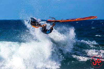
But that's because I'm spoiled. The windsurfers didn't seem to mind the short period waves instead. Photo from this gallery by Jimmie Hepp.

The photo below instead is from the angular spreading swell about 10 days ago and that's where I left my heart. Pristine conditions.

And since I'm getting a bit melodramatic, here's a video illustrating the life of a guy that I like and respect at lot: Dave Kalama.
The moral of it: always listen to what a flag pole has to say to you!
Significant buoy readings 5am:
N
5.9ft @ 8s from 52° (ENE)
Pauwela
5.7ft @ 8s from 50° (NE)
More of the same as the last two days for the north shore. I'm a little fed up with the short period waves, so let's have a good look at the south energy readings:
Lanai
1.3ft @ 15s from 192° (SSW)
W Hawaii
2.2ft @ 14s from 146° (SE)
SE Hawaii
3ft @ 14s from 158° (SSE)
Below is the wind map from September 22. As you might remember, there was another fetch that - I pointed out - could send us an angular spreading swell. And it sure did. Notice how, just like the previous one, the readings have some east at the open ocean W and SE buoys and instead a tiny bit of west at the Lanai one. That's because when coming from a direction with some east, the waves refract over the southern tip of Lanai. I did a whole discussion with graphics in this post, in case you missed it.
Unfortunately, this swell is much smaller than the previous one (the fetch was smaller). And that is also confirmed by what the webcam shows. Pretty low tide in the morning though, I'll keep checking it to see if a little more water improves the size later on.

Current wind map below shows a small/weak NW fetch, the windswell fetch and a small south fetch.
Unfortunately, the NW fetch is going to move north above the Aleutians, so today is pretty much the only day of wave generation for us (yesterday it was even weaker). That will result in a barely noticeable swell that Surfline is forecasting at 2f 10s between Wednesday and Thursday. Notice how much more than the usual 3-4 days those waves are going to take? That's because the wind in the fetch is not as strong as usual and it will only generate short period waves, which travel slower than longer period ones.

To see a better NW swell, we'll have to wait quite a bit. The wind map below is forecasted to happen on October 5th and the related swell is forecasted by Surfline to hit between Saturday 8th and Sunday 9th around 6f 15s.

I took my time this morning to make this call (but I think it came out allright), so here's the updated MC2km map for today at noon, showing a classic moderate windy day on the north shore.

7am update:
In no hurry to go check Hookipa, I kept watching the Lahaina webcam and after 20 minutes, a decent set rolled in. And I captured it for you guys. What a service!


No comments:
Post a Comment