The wind model was wrong and there was more wind that it indicated. As a result, windsurfing happened both at Hookipa and Kanaha. Jimmie Hepp has a large gallery of windsurfing shots, but my two favorites are those of Savanna Stone surfing.


4am significant buoy readings
South shore
W
2ft @ 15s from 251° (WSW)
SW
2.3ft @ 15s from 185° (S)
SE
1.7ft @ 17s from 222° (SW)
Barbers
1.4ft @ 18s from 192° (SSW)
Lanai
1.8ft @ 17s from 207° (SSW)
The good long period numbers at all the buoys should not be a surprise, if you remember the fetches of a week ago. If you don't, below is the collage of the maps of Sept 22, 23, 24 and 24 that show the strong fetch that generated today's swell. Withouth New Zealand in the way, this one would be a pretty big one. Better than nothing, though. Expect low consistency, but nice over waist high sets.

North shore
NW101
6.1ft @ 10s from 9° (N)
N
5.5ft @ 10s from 346° (NNW)
Pauwela
4.8ft @ 11s from 348° (NNW)
3.6ft @ 10s from 350° (N)
NNW swell is here with solid numbers, don't expect any particularly clean surf though (closely generated and with some wind predicted to be on it).
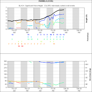
Below is Pauwela's graph. The colored lines are the energy associated with the different periods, the black line is the aggregation of all of them, as explained in this article. The direction is good for Honolua, if any of you guys go and take a picture, please send it to me (email address to the top of the right column).
Below is Pauwela's graph. The colored lines are the energy associated with the different periods, the black line is the aggregation of all of them, as explained in this article. The direction is good for Honolua, if any of you guys go and take a picture, please send it to me (email address to the top of the right column).

Wind map at noon.

North Pacific's today's main fetch is described beautifully by Pat Caldwell:
A storm-force system formed east of Hokkaido, Japan 9/27-28. It is predicted to track east into 9/29 bringing the head of a captured fetch to near 1700 nm away over the 300-310 degree band by mid Saturday. Long period forefunners are due locally in the wee hours Tuesday morning 10/2 centered from 305 degrees, building above the October average Tuesday.
Models show the low pressure near the Date Line 9/29 abruptly changing track to the NE and racing to the eastern Aleutians by late 9/30. This should add energy from 310-345 degrees locally 10/3 while the 300-310 degree energy slowly decreases, keeping breakers near the October average.

South Pacific doesn't have anything good instead.

Morning sky is a bit deceiving, as it doesn't show many clouds, but it's raining on the north shore.

5.15am rain radar shows just that.


No comments:
Post a Comment