3
Thursday, February 06, 2020


Wednesday, February 05, 2020
Wednesday 2 5 20 morning call
After a fun surf session, yesterday I foiled a barely breaking harbor and loved it, just like Donovan here in the photo. Carving on almost nothing is a wonderful sensation.

There you go, a friend of mine just sent me some clips of the session. This was a good one and look at the background. What a day!

4am significant buoy readings and discussion
South shore
No southerly energy at Barbers, check the Lahaina webcam to see what's there.
North shore
NW001
7.3ft @ 12s from 313° (NW)
Waimea
2.6ft @ 13s from 328° (NW)
Pauwela
4.7ft @ 10s from 61° (ENE)
The ENE energy is slowly trending down, but it will still the most noticeable one in the water, at least in the morning. There's some low NW energy too , but a significant increase will be noticeable only in the afternoon, as shown by the below collage of the NW and Pauwela graphs together with the Surfline forecast. Hookipa will have waves probably around head high, possibly bigger when the NW sets will increase. Higher heights from the ENE swell can probably be found on the easterly exposures.

Wind map at noon (the other ones can be found at link n.-2 of GP's meteo websites list in the right column). The whole morning should have no wind or light offshores on the north shore.

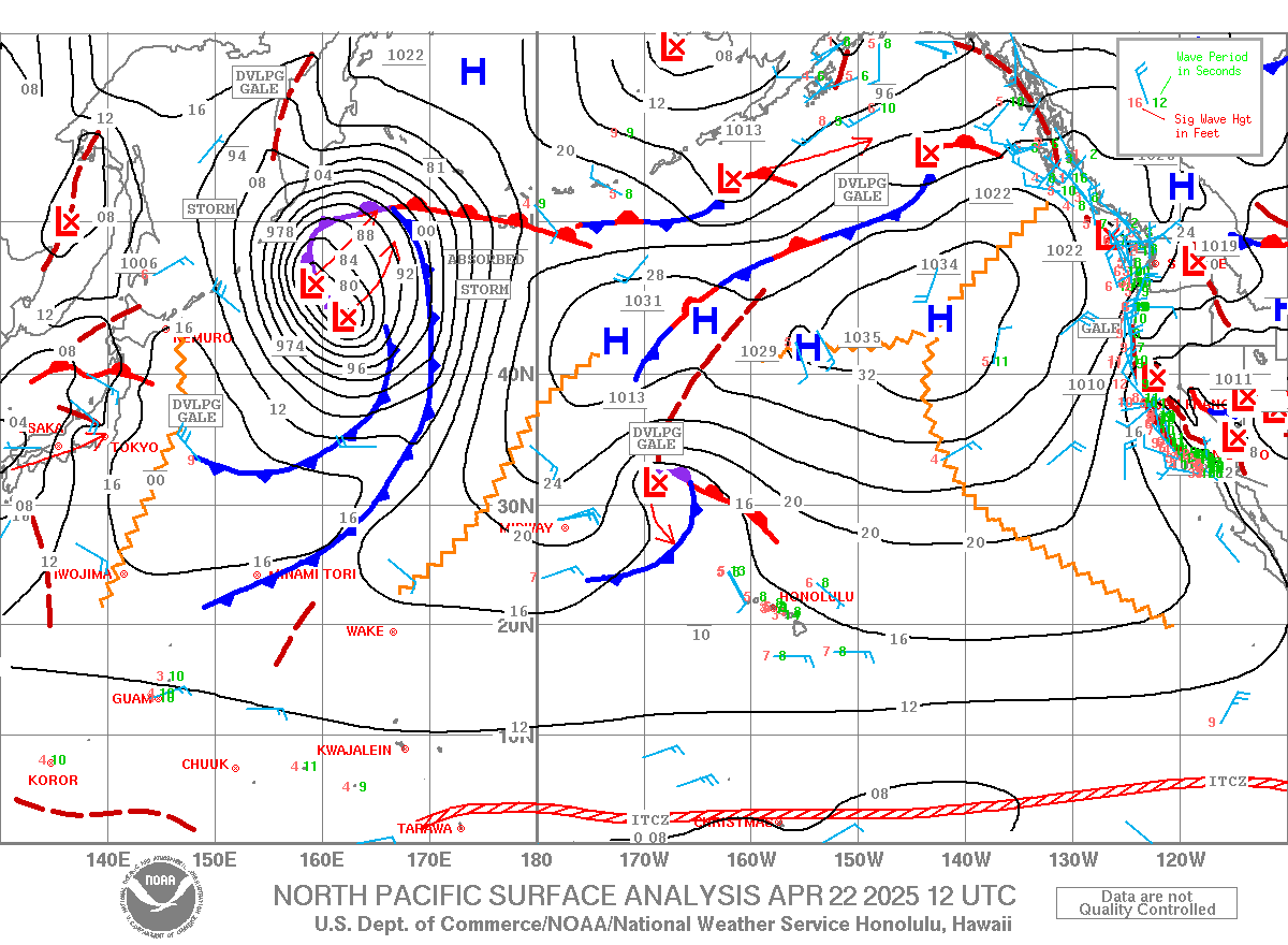
North Pacific has the three fetches circled in red. The one close by to our NNW is the one that will bring the onshores tomorrow, while the distant NW one will intensify and generate a fairly large swell (10ft 15s from 320 predicted by Surfline on Sunday).

South Pacific has a tiny S fetch. The larger one SE of New Zealand is blocked.

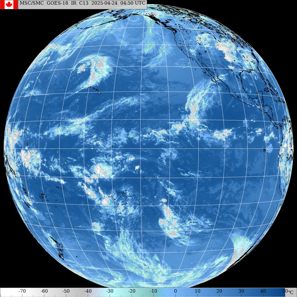
Morning sky. You can see the predicted front already on Kauai.


There you go, a friend of mine just sent me some clips of the session. This was a good one and look at the background. What a day!

4am significant buoy readings and discussion
South shore
No southerly energy at Barbers, check the Lahaina webcam to see what's there.
North shore
NW001
7.3ft @ 12s from 313° (NW)
Waimea
2.6ft @ 13s from 328° (NW)
Pauwela
4.7ft @ 10s from 61° (ENE)
1.7ft @ 14s from 329° (NW)
The ENE energy is slowly trending down, but it will still the most noticeable one in the water, at least in the morning. There's some low NW energy too , but a significant increase will be noticeable only in the afternoon, as shown by the below collage of the NW and Pauwela graphs together with the Surfline forecast. Hookipa will have waves probably around head high, possibly bigger when the NW sets will increase. Higher heights from the ENE swell can probably be found on the easterly exposures.

Wind map at noon (the other ones can be found at link n.-2 of GP's meteo websites list in the right column). The whole morning should have no wind or light offshores on the north shore.

North Pacific has the three fetches circled in red. The one close by to our NNW is the one that will bring the onshores tomorrow, while the distant NW one will intensify and generate a fairly large swell (10ft 15s from 320 predicted by Surfline on Sunday).

South Pacific has a tiny S fetch. The larger one SE of New Zealand is blocked.
Morning sky. You can see the predicted front already on Kauai.

Tuesday, February 04, 2020
Tuesday 2 4 20 morning call
I bet this photo will make many long time Maui north shore residents smile, as they will recognize uncle Joe who moved two years ago to Las Vegas to be with his family. Still doing his things and sending kisses to the passing cars, as he used to do here.

This is my pick of Jimmie Hepp's album of the windsurfing action at Hookipa. I windsurfed too (out of lack of alternatives) and that reminded why I don't like strong wind anymore.

5am significant buoy readings and discussion
South shore
Barbers
1ft @ 12s from 182° (S)
North shore
NW001
2ft @ 15s from 319° (NW)
Pauwela
7.1ft @ 9s from 68° (ENE)


North Pacific has the three fetches I circled in red.

South Pacific has a fetch deep down in the Tasman Sea.

Morning sky. Enjoy the sunshine, as a front is predicted to brush the islands on Thursday.


This is my pick of Jimmie Hepp's album of the windsurfing action at Hookipa. I windsurfed too (out of lack of alternatives) and that reminded why I don't like strong wind anymore.

5am significant buoy readings and discussion
South shore
Barbers
1ft @ 12s from 182° (S)
0.7ft @ 15s from 209° (SSW)
Couple of small readings at Barbers, doesn't look like much on the Lahaina webcam.
North shore
NW001
2ft @ 15s from 319° (NW)
Pauwela
7.1ft @ 9s from 68° (ENE)
NW buoy registers a couple of feet of long period NW energy. That's the low start of a bigger NW swell that will be much more noticeable tomorrow, as Pat Cadlwell describes in this way:
A large area of low pressure formed west of the Date Line 1/30-31. The low pressure occluded by 2/1 with central pressure dropping to 948 mb. Oddly enough the large fetch aimed at Hawaii had much weaker winds than one would guess given the low pressure center. ASCAT satellite showed mostly marginal gales 1/31-2/3 over a wide, long fetch of 290-330 degrees nosing just east of the Date Line 2/3. The low center is weakening as it moves east along the Aleutians at the Date Line Monday 2/3. It is expected to fade out Tuesday.
Wave Watch III suggest a low event picking up Tuesday 2/4 from 290-315 degrees. Better odds by Wednesday morning with surf climbing to just under the seasonal average from 290-330 degrees.
Wave Watch III suggest a low event picking up Tuesday 2/4 from 290-315 degrees. Better odds by Wednesday morning with surf climbing to just under the seasonal average from 290-330 degrees.
Below is the collage of the maps of Jan 31, Feb 1, 2 and 3 that will help follow.

But, as pointed out earlier, that's more for tomorrow. Today the main energy will still be provided by the close by NE fetches that you can notice in the collage above in the past few days. With that reading at Pauwela, I don't expect to see much more than head high waves at Hookipa (will probably report later), possibly higher on eastern exposures. So, a relatively small day for the season, but with clean conditions for most of the morning.
Wind map at noon (the other ones can be found at link n.-2 of GP's meteo sites list)
Wind map at noon (the other ones can be found at link n.-2 of GP's meteo sites list)

North Pacific has the three fetches I circled in red.

South Pacific has a fetch deep down in the Tasman Sea.

Morning sky. Enjoy the sunshine, as a front is predicted to brush the islands on Thursday.

Monday, February 03, 2020
Monday 2 3 20 morning call
Thanks to blog reader Beau for his donation.
Day two of the GoFoil team riders meeting was held at the harbor. This two days meeting might have just pushed the level of foiling one step higher. The things I see today were quite inconceivable a couple of years ago when the SUP/surf foiling movement started (mostly thanks to GoFoil in Maui).
Check out Austin Kalama for example, who took off on this double up at Jetty's. With a slight bend in his knees his body is about 5 feet tall (that's what head high is btw, 5 feet faces). The mast is at least 1.5 feet out of the water and there's a couple of more feet of wave over his head, so that wave's face is 9-10 feet (not unusual at all at that spot). Not only he was able to negotiate the steep drop...

...but also went for this crazy air rotation (he went off the back).

Or take Derek Hamasaki from Oahu, who can slash the tail of his board like if it was a surfboard (he pulled it off no problem).

This young ripper is from Oahu. There were many visitors from the other islands, it seems that Maui has the best foiling waves (at least that's something!).

Well, we do have one world class wave (or two, the rare occasions when Maalaea is firing). Honolua was the place to be on Superbowl Sunday.

This is my pick of Jimmie Hepp's album of the daily windsurfing action at Hookipa.


North Pacific has a large NW and a ENE windswell fetch.

South Pacific has a small and remote S fetch for the third day in a row and a Tasman sea one.

Morning sky.

Day two of the GoFoil team riders meeting was held at the harbor. This two days meeting might have just pushed the level of foiling one step higher. The things I see today were quite inconceivable a couple of years ago when the SUP/surf foiling movement started (mostly thanks to GoFoil in Maui).
Check out Austin Kalama for example, who took off on this double up at Jetty's. With a slight bend in his knees his body is about 5 feet tall (that's what head high is btw, 5 feet faces). The mast is at least 1.5 feet out of the water and there's a couple of more feet of wave over his head, so that wave's face is 9-10 feet (not unusual at all at that spot). Not only he was able to negotiate the steep drop...

...but also went for this crazy air rotation (he went off the back).

Or take Derek Hamasaki from Oahu, who can slash the tail of his board like if it was a surfboard (he pulled it off no problem).

This young ripper is from Oahu. There were many visitors from the other islands, it seems that Maui has the best foiling waves (at least that's something!).

Well, we do have one world class wave (or two, the rare occasions when Maalaea is firing). Honolua was the place to be on Superbowl Sunday.

This is my pick of Jimmie Hepp's album of the daily windsurfing action at Hookipa.

4am significant buoy readings and discussion
South shore
Barbers
2.8ft @ 8s from 167° (SSE)
North shore
N
9.2ft @ 10s from 27° (NNE)
Pauwela
South shore
Barbers
2.8ft @ 8s from 167° (SSE)
1.5ft @ 10s from 208° (SSW)
1.4ft @ 12s from 198° (SSW)
0.9ft @ 16s from 207° (SSW)
All kind of SSE and SSW energy (from unidentified sources) at Barbers, the Lahaina webcam does show some small waves.
North shore
N
9.2ft @ 10s from 27° (NNE)
Pauwela
6.2ft @ 9s from 48° (NE)
6.2ft @ 11s from 14° (NNE)
1.8ft @ 4s from 76° (ENE)
Today it's all about the NNE to NE energy that we see at the N and Pauwela buoys (tomorrow the same with smaller sizes). Hookipa and all the north to east exposures will have pretty good size waves. I might post a beach report later this morning.
Wind map at noon
Wind map at noon

North Pacific has a large NW and a ENE windswell fetch.

South Pacific has a small and remote S fetch for the third day in a row and a Tasman sea one.

Morning sky.

Sunday, February 02, 2020
Sunday 2 2 20 morning call
Massive participation to a GoFoil riders event yesterday at Kaa. Photo by Jason Hall.

I had the pleasure to meet Tahitian ripper Mathai Drollet, who recently posted an incredible clip of foiling an Oahu outer reef. Only on Instagram unfortunately, can't share it here, but the guy is a freak. Hopefully we'll see more of him today at Kaa (and possibly later at the harbor).

This is my pick of Jimmie Hepp's album of the Hookipa windsurfing action.

4am significant buoy readings and discussion
South shore
No indication of southerly energy at Barbers, check the Lahaina webcam.
North shore
NW001
6.2ft @ 11s from 35° (NE)

Let me comment on the size of the low that is taking the whole western north Pacific. The isobars are not particularly close in the section that interests us, so it's not going to be another XL swell, but it'll still be a fairly large one. Unfortunately we'll have unfavorable local winds when it arrives around Wednesday/Thursday.

North Pacific shows the fetch associated with the low discussed above and a local NE windswell one.

South Pacific has pretty much the same exact fetch as yesterday.

Morning sky.


I had the pleasure to meet Tahitian ripper Mathai Drollet, who recently posted an incredible clip of foiling an Oahu outer reef. Only on Instagram unfortunately, can't share it here, but the guy is a freak. Hopefully we'll see more of him today at Kaa (and possibly later at the harbor).

This is my pick of Jimmie Hepp's album of the Hookipa windsurfing action.

4am significant buoy readings and discussion
South shore
No indication of southerly energy at Barbers, check the Lahaina webcam.
North shore
NW001
6.2ft @ 11s from 35° (NE)
5.1ft @ 10s from 56° (ENE)
4.5ft @ 7s from 62° (ENE)
Waimea
7.9ft @ 13s from 354° (N)
Waimea
7.9ft @ 13s from 354° (N)
4ft @ 9s from 2° (N)
Pauwela
7.6ft @ 13s from 351° (N)
Pauwela
7.6ft @ 13s from 351° (N)
5.7ft @ 10s from 44° (NE)
As predicted, the swell turned more north, and the direction is going to follow the trajectory of the fetch and turn more NE during the day. Hookipa will be plenty overhead and probably not particularly clean, I don't think I'll bother checking it out, so no beach report today.
Kahului tides
Sorry, I'm not going to post the tides anymore. They are so easy to find online (I use links 12 and 12b) and for me is just time consuming copy and paste with no added value. Plus, tides are overrated in Hawaii and you never want to wait for the tide to be right for a spot if the wind is right at that moment. In Maui, wind over tide, always.
Wind map at noon
Kahului tides
Sorry, I'm not going to post the tides anymore. They are so easy to find online (I use links 12 and 12b) and for me is just time consuming copy and paste with no added value. Plus, tides are overrated in Hawaii and you never want to wait for the tide to be right for a spot if the wind is right at that moment. In Maui, wind over tide, always.
Wind map at noon

Let me comment on the size of the low that is taking the whole western north Pacific. The isobars are not particularly close in the section that interests us, so it's not going to be another XL swell, but it'll still be a fairly large one. Unfortunately we'll have unfavorable local winds when it arrives around Wednesday/Thursday.

North Pacific shows the fetch associated with the low discussed above and a local NE windswell one.

South Pacific has pretty much the same exact fetch as yesterday.

Morning sky.

Saturday, February 01, 2020
Saturday 2 1 20 morning call
Another day of wonderful waves, this is Hookipa in the morning.

Charlie Smith liked the 6.8 Bushman I was carrying while we met in the parking lot (I bought it used before going to Italy). Then he went out and ripped as usual.

It was another easterly trades day and this is my pick of Jimmie Hepp's album.

This is Hookipa at sunset. Bigger than the morning.

This photo shows the medium period of the swell.

5am significant buoy readings and discussion
South shore
No southerly energy at Barbers, check the Lahaina webcam to see what's there. It's possible that during the day a small N wrap will appear.
North shore
NW001
8.2ft @ 13s from 354° (N)
Waimea
8.2ft @ 13s from 330° (NW)
Pauwela
6.6ft @ 13s from 334° (NNW)
Kahului Tides
High Tide High Tide Low Tide Low Tide Sunrise Sunset
5:59a +1.6 10:36p +1.4 1:52p +0.4 7:04a 6:18p
North Pacific has the fetched circled in red. The NW one belongs to a new large low that formed in the NW sector.

Nice fetch down south. I circled in red the part that is for sure oriented towards us. The yellow part falls outside the great circle ray map on the right, so we don't know if it's actually aiming at us. Down there the flat map induced distortion is so high, that the chances are very low.

Morning sky.


Charlie Smith liked the 6.8 Bushman I was carrying while we met in the parking lot (I bought it used before going to Italy). Then he went out and ripped as usual.

It was another easterly trades day and this is my pick of Jimmie Hepp's album.

This is Hookipa at sunset. Bigger than the morning.

This photo shows the medium period of the swell.

5am significant buoy readings and discussion
South shore
No southerly energy at Barbers, check the Lahaina webcam to see what's there. It's possible that during the day a small N wrap will appear.
North shore
NW001
8.2ft @ 13s from 354° (N)
Waimea
8.2ft @ 13s from 330° (NW)
Pauwela
6.6ft @ 13s from 334° (NNW)
5.5ft @ 11s from 40° (NE)
4.3ft @ 7s from 75° (ENE)
The 13s energy comes from the fetch of that low north of the islands we saw a couple of days ago that raced east very fast. 334 is a great direction for Honolua, which will offer the best waves (seen the easterly trades). As you can see, the NW buoys already shows a more north direction and that is going to be the trend during the day. Plenty NE windswell too which will make the breaking pattern less clean than it's been lately. Hookipa will have big waves again (at least head and a half), I will possibly report later.
Wind map at noon

Wind map at noon

Kahului Tides
High Tide High Tide Low Tide Low Tide Sunrise Sunset
5:59a +1.6 10:36p +1.4 1:52p +0.4 7:04a 6:18p
North Pacific has the fetched circled in red. The NW one belongs to a new large low that formed in the NW sector.

Nice fetch down south. I circled in red the part that is for sure oriented towards us. The yellow part falls outside the great circle ray map on the right, so we don't know if it's actually aiming at us. Down there the flat map induced distortion is so high, that the chances are very low.

Morning sky.

Subscribe to:
Posts (Atom)