Here's a photo from this gallery by Jimmie Hepp that shows that Hookipa still had plenty size. Amazing what 3f 11s (plus windswell) can do when coming from an unblocked direction.

3-4am significant buoy readings
North shore
N
3.7ft @ 10s from 341° (NNW)
Pauwela
4.9ft @ 8s from 65° (ENE)
2.8ft @ 6s from 67° (ENE)
2.6ft @ 10s from 349° (NNW)
0.6ft @ 15s from 346° (NNW)
The usual mix of periods and directions at the Pauwela buoy, the ocean will reflect that. Pretty sure it's still head high out there, but it should be smaller than yesterday.
South shore
Lanai
South shore
Lanai
1.1ft @ 13s from 198° (SSW)
0.9ft @ 16s from 199° (SSW)
Barbers
1.4ft @ 16s from 197° (SSW)
1.4ft @ 16s from 197° (SSW)
1.4ft @ 12s from 193° (SSW)
Lovely small pulse of long period energy at the local south facing buoys, let's see where that is coming from. Seeing the fetch where a swell comes from for me is an absolutely key thing to do.
Lovely small pulse of long period energy at the local south facing buoys, let's see where that is coming from. Seeing the fetch where a swell comes from for me is an absolutely key thing to do.
If you surf that swell, in fact, you can learn what the length, width, overall area, intensity of the wind, distance of the fetch do to: size, consistency, number of waves in the set, etc.
It does take an analytical mind to do that, and probably 90% of the surfers won't care too much about it, but I'm sure there's some other weird guys like me out there.
It does take an analytical mind to do that, and probably 90% of the surfers won't care too much about it, but I'm sure there's some other weird guys like me out there.
Here's the map of 7 days ago, October 17 and here's what Pat Caldwell wrote on Friday: A gale low pressure moved slowly east along 45°S to the east of New Zealand to south of French Polynesia 10/17-20. The winds were magnitude deficient, so only a small event is expected locally. It should pick up Monday from 170-190 degrees, peak late Monday, then linger into Wednesday.
The fetch associated with the low he meant and the one responsible for the 16s readings is the lower one. It's likely that the one right north of it is the one adding the 13s energy.
I actually like a lot better the map of the day after, October 18. That means that tomorrow this south swell should be stronger. 1.8f 15s predicted by Surfline.

Current wind map shows that fetch off Kamchatka getting bigger but not quite much stronger just yet and a tiny remnant of that gulf of Alaska fetch that has been providing this long lasting northerly energy.
Also a small fetch in the Tasman sea, but Fijian archipelago will probably block most of the energy. As a matter of fact, Surfline is calling for 6f 12s for down there between Thursday and Friday. Sounds like epic Restaurants to me! Mmm... maybe I should skip the windsurfing contest and get on a plane to catch that...

Without access to the MC2km website, I'm looking for alternatives.
Here's a couple of models available on the Windity page. This one is called ECMWF and is showing a direction of 60 degrees at noon at Hookipa.

This other one is the NAM3km and it shows 90 degrees instead. That's a huge gap and it's gonna be easy to verify which one was right... unless the direction will be 75, of course.

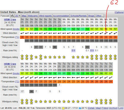
One more option: the HRW model at the very bottom of the Windguru page. That is calling for 62 degrees and a pretty solid cloud cover throughout all day. We shall see.


No comments:
Post a Comment