It's the last week of the year, please feel free to show your appreciation for the 2018 season of the blog with a donation via the Paypal button. Thanks.
December has been totally epic for the wind related sports, here's a happy windsurfer at Hookipa yesterday in this photo by Jimmie Hepp from this gallery.

The swell that hit Thursday/Friday was pretty west but big/long period enough to allow it to wrap into Honolua Bay. This is my friend Marco. Not sure what day though.

5am significant buoy readings
South shore
Barbers
3.6ft @ 8s from 169° (SSE)
0.6ft @ 18s from 224° (SW)
Lanai
3.5ft @ 8s from 169° (SSE)
0.6ft @ 18s from 193° (SSW)
Once again the local buoys show a sliver of long period energy from the SSW and once again all you can see at Ala Moana is the short period one from the SSE. It shouldn't be flat either on the south facing shores of Maui, but not by much.
6.3ft @ 10s from 75° (ENE) Pauwela
7.7ft @ 9s from 66° (ENE)
Not a single reading from the NW quadrant at any buoys on December 31st, that's a sign that this has been a bit of an unusual winter so far. Waimea shows a bit of 9s energy from the N, but as Mokapu shows, that's just the easterly windswell wrapping into Oahu's north shore. So windswell only of offer today. Actually, let me correct myself: windswell and wind.
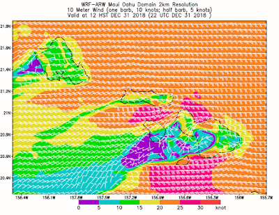
Wind map at noon.

North Pacific has the same WNW and NW fetches we saw yesterday, but the first one got a lot closer. When a fetch moves in the direction of the waves it's generating, it's called captured and it's one of the conditions for extra large waves. Unfortunately this one remains from a direction that will be partially blocked for us. Surfline predicts 8.7f 15s from 307 on Thursday.

Nothing of relevance from the South.

Morning sky.


