6.45am Hookipa is head high and unfortunately the kona is blowing moderate already.
Still a 6.5, but it will deteriorate as the wind increases.
Wednesday, January 31, 2018
Wednesday 1 31 18 morning call
A shortboard and a windsurf session for me yesterday. I also took the photos below.
This is one of my favorite waves to shoot with the Kona, they all look good with it, but this one in particular becomes something else.
Bruddah Cruz.
The Jetty was doing its thing.
Outside too.
After a free fall drop, this guy managed to get in the barrel and come out clean.
This is going to be a different kind of free fall... straight to the bottom. My estimate of the distance between his head and the water is at least 3m. We all know how much higher than the pictures that feels when you're up there.
The camera focused on the spray of the wave in front, but I want to post this anyway because it shows bodyboard extraordinaire Jacob Romero dropping in a bomb with such a long wall that it seemed impossible for me to come out of the barrel.
23 shots later instead he came flying out waaay down the line.
The information provided by this model is 36 hours old (as such, it's not quite as reliable as the good old defunct Maui County @2km), it's a little unfriendly to use (got to change the "tau" parameter to see the different times), but it's still the best available out there (link n. -4), so I want to thank my friend Dan who takes care of updating it.

North Pacific shows a pretty big NW fetch.

Lovely Tasman Sea fetch in the South Pacific

Morning sky. The front is on Oahu at the moment and it's passing over us will cause the wind changes illustrated above.

This is one of my favorite waves to shoot with the Kona, they all look good with it, but this one in particular becomes something else.
Bruddah Cruz.
The Jetty was doing its thing.
Outside too.
After a free fall drop, this guy managed to get in the barrel and come out clean.
This is going to be a different kind of free fall... straight to the bottom. My estimate of the distance between his head and the water is at least 3m. We all know how much higher than the pictures that feels when you're up there.
The camera focused on the spray of the wave in front, but I want to post this anyway because it shows bodyboard extraordinaire Jacob Romero dropping in a bomb with such a long wall that it seemed impossible for me to come out of the barrel.
23 shots later instead he came flying out waaay down the line.
4am significant buoy readings
South shore
No indication of southerly energy at the buoys, the Surfline forecast calls for pretty much nothing.South shore
North shore
NW101
4.6ft @ 12s from 327° (NW)
Waimea
5.1ft @ 13s from 349° (NNW)
Pauwela
5.1ft @ 13s from 1° (N)
4.7ft @ 10s from 73° (ENE)
Yesterday's N swell peaked and today it's predicted to slowly decline throughout the day. Might be up to 2f and 1s less at sunset, but starting at 5f 13s there's still gonna be waves all day. Let's also not forget the resilient easterly swell still in the water.
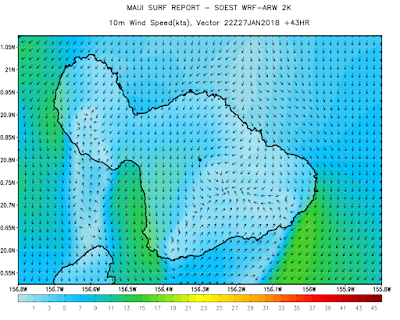
Below is the collage of the wind maps at the hours I wrote in red. As you can see, the early morning will have Kona wind in the Kahului area (blowing 19mps at 5am while I'm typing), but not in the Hookipa area. Around 9am the Kona will reach Hookipa. At noon it will start lightening up. At 2pm a switch should start happening and at 4pm it should be light onshore. 6pm looks lighter.
The knowledge of what the wind is going to do is MUCH more important of the knowledge of what the swell is going to do.

North Pacific shows a pretty big NW fetch.

Lovely Tasman Sea fetch in the South Pacific

Morning sky. The front is on Oahu at the moment and it's passing over us will cause the wind changes illustrated above.

Tuesday, January 30, 2018
Tuesday 1 30 18 morning call
Just a shortboard session for me yesterday, as I was busy packing as many work engagements as possible and free myself up before the very exciting stretch of excellent surf we're headed to.
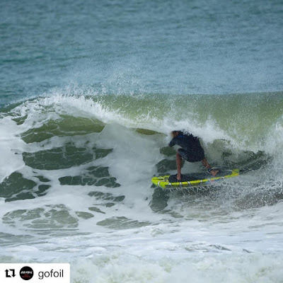
Photo of the day goes to Austin Kalama who managed to get barreled on a foil SUP board (!) at Sebastian Inlet (FL). Photo from the Gofoil page. Why would he try to get barreled on a foil? Because he can.
4-5am significant buoy readings
South shore
No indication of southerly energy at the buoys, the Surfline forecast calls for declining 0.9f 12s.
North shore
NW101
7.6ft @ 13s from 320° (NW)
Waimea
7.2ft @ 13s from 359° (N)
Pauwela
New northerly pulse is up at the buoys. Below is the collage of the three reported ones together with the Surfline forecast. As you can see, it seems that the swell has arrived well before the prediction. If it wasn't for the 5f 10s of easterly swell still in the water, I would call the conditions at Hookipa a 10 from home.

Let's have a look at that "very exciting stretch of excellent surf we're headed to" I mentioned above. First, below is the collage of the fetches of the last four days: Jan 26,27,28 and 29. The northerly fetch will be the main source of energy today and tomorrow, before the NW fetch on the 29 and 30 maps will send us a bigger NW swell on Thursday and after that an even bigger swell (possibly extra large) will arrive in the weekend.

But that has very little to do with my claim. What will make the conditions excellent is, as usual, the wind. Below is the Windguru wind prediction for the rest of the week, and that is the best surf forecast you can imagine for Maui's north shore (even though I made sure to pick a model that doesn't show any information about the waves).

Well, that is if those wind speeds would be confirmed. Reality is that Maui's two big mountains love to squeeze the air molecules and accelerate them. This is the wind map at noon and that Kona wind seems way too strong to still be ideal for surfing (might even be enough for windsurfing). Fortunately in the earlier hours the wind should be much lighter. We'll see, it's totally quiet at the moment at 6am, don't wait too long is my recommendation.

North Pacific shows a close by NW fetch. For the first time in like 2 weeks, there's no easterly fetch. The medium period easterly swell has been unusually long lasting, also because for the last few days it was not accompanied by the local trades.

Nothing of relevance in the South Pacific.

Morning sky.

Photo of the day goes to Austin Kalama who managed to get barreled on a foil SUP board (!) at Sebastian Inlet (FL). Photo from the Gofoil page. Why would he try to get barreled on a foil? Because he can.

4-5am significant buoy readings
South shore
No indication of southerly energy at the buoys, the Surfline forecast calls for declining 0.9f 12s.
North shore
NW101
7.6ft @ 13s from 320° (NW)
Waimea
7.2ft @ 13s from 359° (N)
Pauwela
6.7ft @ 14s from 359° (N)
4.9ft @ 10s from 70° (ENE)
New northerly pulse is up at the buoys. Below is the collage of the three reported ones together with the Surfline forecast. As you can see, it seems that the swell has arrived well before the prediction. If it wasn't for the 5f 10s of easterly swell still in the water, I would call the conditions at Hookipa a 10 from home.

Let's have a look at that "very exciting stretch of excellent surf we're headed to" I mentioned above. First, below is the collage of the fetches of the last four days: Jan 26,27,28 and 29. The northerly fetch will be the main source of energy today and tomorrow, before the NW fetch on the 29 and 30 maps will send us a bigger NW swell on Thursday and after that an even bigger swell (possibly extra large) will arrive in the weekend.

But that has very little to do with my claim. What will make the conditions excellent is, as usual, the wind. Below is the Windguru wind prediction for the rest of the week, and that is the best surf forecast you can imagine for Maui's north shore (even though I made sure to pick a model that doesn't show any information about the waves).

Well, that is if those wind speeds would be confirmed. Reality is that Maui's two big mountains love to squeeze the air molecules and accelerate them. This is the wind map at noon and that Kona wind seems way too strong to still be ideal for surfing (might even be enough for windsurfing). Fortunately in the earlier hours the wind should be much lighter. We'll see, it's totally quiet at the moment at 6am, don't wait too long is my recommendation.

North Pacific shows a close by NW fetch. For the first time in like 2 weeks, there's no easterly fetch. The medium period easterly swell has been unusually long lasting, also because for the last few days it was not accompanied by the local trades.

Nothing of relevance in the South Pacific.

Morning sky.

Monday, January 29, 2018
Monday 1 29 18 morning call
A shortboard and a windfoiling session for me yesterday. In between, I had the pleasure to teach my buddy Russ a quick windfoiling lesson and he did amazingly well. Off he goes, 15 minutes into it.

He tried SUP foiling once back in March 2017 and he didn't do as well. Before I get into the analysis of the advantages of learning windfoiling vs SUP foiling, I do have to specify that yesterday he was on a Gofoil Maliko 200, while in his first SUP foiling attempt he was using the Gofoil Kai. There's two sizes difference between the two and it is pretty obvious that the bigger the foil, the easier it is to learn because of the two following reasons:
- a bigger foil foils at slower speed and that means more control and less fear (and less danger)
- a bigger foil is more stable
Said that, everything I say below applies nonetheless, even with the same size foil. This is a brief list of reasons why windfoiling is a lot easier to learn than SUP or surf foiling:
- hanging on the boom and having a third point of contact with the board (the rig) greatly helps the balance
- to get the same amount of foiling practice you get in 15 minutes of windfoiling, you probably need 5 one hour sessions of SUP foiling (and I'm being conservative)
- when SUP foiling, the speed at which you go is regulated mostly by the wave and that is much more out of your control than when you windfoil where instead you can pump the sail to accelerate and sheet it out to slow down
- overall, the face of a wave is a much more dynamically changing environment than the relatively flat surface of the ocean in a light wind day
For pretty much the same reasons, learning while towed by a jet ski is a much easier way than learning on a wave. Unfortunately I never tried that, but I did try behind a boat that made a big wake and lots of bubbles and that was pretty horrible. I'm sure a ski would be a lot better than that boat, but nonetheless I am absolutely convinced that windfoiling is even easier than that, since it's the sailor who is in charge of regulating the speed, not the ski driver. Plus, for 99% of the windsurfers, being towed by a ski is a much more foreign feeling than windsurfing (which windfoiling pretty much is, until the foil lifts the board off the water).
So, if you're a windsurfer and won't give windfoiling a try, you're missing out on a lot of fun. But if you're a windsurfer and you're trying to learn SUP or surf foiling without learning windfoiling first, you're doing an ENORMOUS mistake.
Here's the videos of both Russ's first attempts, judge by yourself.
BTW, if you're not a windsurfer and want to learn how to SUP foil, don't get discouraged by this article. The vast majority of the SUP foilers out there learned by just SUP foiling. It's just pretty hard at first, but it's definitely achievable if you stick to it. Do get a jet ski assistance first, if you can.
And while I'm at it, here's a brief discussion of large foils vs small ones.
Here's a list of characteristics that change when you change foil size (no matter the discipline). I'm going to just define them as proportional (P) or inversely proportional (IP) to the foil size.
Stability (both when foiling or just paddling): P
Drag under water: P
Lift: P
Speed at which the foil first starts foiling: IP
Speed at which the foil first starts getting out of control because it can't handle it: IP
Foiling speed: IP
Paddling speed: IP
Pumping ability: P
Distance you can cover on a small mushy wave: P
Below is a diagram that illustrates how the "comfortable" foiling speed ranges change when you change the size of the foil. It's only qualitative, I wouldn't dare putting numbers on it (because I don't know them). The M200, IWA and KAI are three progressively smaller models of the Gofoil foils (the ones I own at the moment). I also added the range of a high speed kite foil (never tried one, this is based on my empirical observations in the water). It might overlap a bit with the range of the surfing foil, I just wanted to exaggerate the fact that it starts foiling at much higher speed.

4am significant buoy readings
South shore
No indication of southerly energy at the buoys, the Surfline forecast calls for 0.8f 15s.
North shore
NW101
Waimea
Pauwela
6.8ft @ 11s from 73° (ENE)
Even though it's possible that there's also some low NW/N energy in the water, the Pauwela buoy only shows the easterly swell and that's what most of the waves on the north shore will be provided by today. Stay tuned for a Hookipa beach report for size and conditions.
Wind map at noon shows light onshores.

North Pacific shows NW, N and E fetches.

Little south fetch in the South Pacific.

Morning sky.


He tried SUP foiling once back in March 2017 and he didn't do as well. Before I get into the analysis of the advantages of learning windfoiling vs SUP foiling, I do have to specify that yesterday he was on a Gofoil Maliko 200, while in his first SUP foiling attempt he was using the Gofoil Kai. There's two sizes difference between the two and it is pretty obvious that the bigger the foil, the easier it is to learn because of the two following reasons:
- a bigger foil foils at slower speed and that means more control and less fear (and less danger)
- a bigger foil is more stable
Said that, everything I say below applies nonetheless, even with the same size foil. This is a brief list of reasons why windfoiling is a lot easier to learn than SUP or surf foiling:
- hanging on the boom and having a third point of contact with the board (the rig) greatly helps the balance
- to get the same amount of foiling practice you get in 15 minutes of windfoiling, you probably need 5 one hour sessions of SUP foiling (and I'm being conservative)
- when SUP foiling, the speed at which you go is regulated mostly by the wave and that is much more out of your control than when you windfoil where instead you can pump the sail to accelerate and sheet it out to slow down
- overall, the face of a wave is a much more dynamically changing environment than the relatively flat surface of the ocean in a light wind day
For pretty much the same reasons, learning while towed by a jet ski is a much easier way than learning on a wave. Unfortunately I never tried that, but I did try behind a boat that made a big wake and lots of bubbles and that was pretty horrible. I'm sure a ski would be a lot better than that boat, but nonetheless I am absolutely convinced that windfoiling is even easier than that, since it's the sailor who is in charge of regulating the speed, not the ski driver. Plus, for 99% of the windsurfers, being towed by a ski is a much more foreign feeling than windsurfing (which windfoiling pretty much is, until the foil lifts the board off the water).
So, if you're a windsurfer and won't give windfoiling a try, you're missing out on a lot of fun. But if you're a windsurfer and you're trying to learn SUP or surf foiling without learning windfoiling first, you're doing an ENORMOUS mistake.
Here's the videos of both Russ's first attempts, judge by yourself.
BTW, if you're not a windsurfer and want to learn how to SUP foil, don't get discouraged by this article. The vast majority of the SUP foilers out there learned by just SUP foiling. It's just pretty hard at first, but it's definitely achievable if you stick to it. Do get a jet ski assistance first, if you can.
And while I'm at it, here's a brief discussion of large foils vs small ones.
Here's a list of characteristics that change when you change foil size (no matter the discipline). I'm going to just define them as proportional (P) or inversely proportional (IP) to the foil size.
Stability (both when foiling or just paddling): P
Drag under water: P
Lift: P
Speed at which the foil first starts foiling: IP
Speed at which the foil first starts getting out of control because it can't handle it: IP
Foiling speed: IP
Paddling speed: IP
Pumping ability: P
Distance you can cover on a small mushy wave: P
Below is a diagram that illustrates how the "comfortable" foiling speed ranges change when you change the size of the foil. It's only qualitative, I wouldn't dare putting numbers on it (because I don't know them). The M200, IWA and KAI are three progressively smaller models of the Gofoil foils (the ones I own at the moment). I also added the range of a high speed kite foil (never tried one, this is based on my empirical observations in the water). It might overlap a bit with the range of the surfing foil, I just wanted to exaggerate the fact that it starts foiling at much higher speed.

4am significant buoy readings
South shore
No indication of southerly energy at the buoys, the Surfline forecast calls for 0.8f 15s.
North shore
NW101
7.5ft @ 10s from 53° (ENE)
3.8ft @ 14s from 299° (WNW)
Waimea
4.7ft @ 11s from 356° (N)
2.4ft @ 10s from 357° (N)
1.3ft @ 16s from 317° (NW)
Pauwela
6.8ft @ 11s from 73° (ENE)
Even though it's possible that there's also some low NW/N energy in the water, the Pauwela buoy only shows the easterly swell and that's what most of the waves on the north shore will be provided by today. Stay tuned for a Hookipa beach report for size and conditions.
Wind map at noon shows light onshores.

North Pacific shows NW, N and E fetches.

Little south fetch in the South Pacific.

Morning sky.

Sunday, January 28, 2018
Sunday 1 28 18 morning call
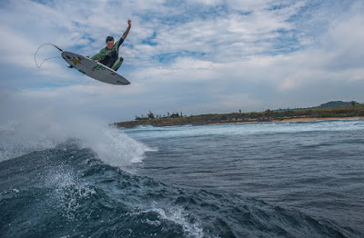
A longboard and a SUP foiling session for me yesterday. No photo of the day, I'm gonna grab another shot by Dayanidhi Das from this article on Surfline. That's Albee Layer and fortunately that's not one of the two boards I got from him lately. But I'm sure he did plenty of that with them too.
This is just a random extract of the long term Surfline forecast for the north shore. It's subscriber's material (which I'm not supposed to share), so I won't even indicate the dates, but - if it stays like that - that's three big NW swells in a row (scale is 8-16 feet). It's still winter in Hawaii.

4-5am significant buoy readings
South shore
No indication of southerly energy at the buoys, the Surfline forecast calls for 0.9f 16s. Below are the maps of Jan 20, 21 and 22 showing the distant and not particularly well oriented fetch where this low long period swell is coming from.

North shore
NW101
6.7ft @ 11s from 2° (N)
Waimea
3.2ft @ 12s from 356° (N)
Wind map at noon shows light trades.

North Pacific shows a wide but not too strong WNW fetch, a small NNW one and a weakening E one.

Small southerly fetch in the South Pacific.

Morning sky shows that we're on the edge of a massive band of clouds. Forecasting clouds and rain is not my thing, so I will refrain.


This is just a random extract of the long term Surfline forecast for the north shore. It's subscriber's material (which I'm not supposed to share), so I won't even indicate the dates, but - if it stays like that - that's three big NW swells in a row (scale is 8-16 feet). It's still winter in Hawaii.

4-5am significant buoy readings
South shore
No indication of southerly energy at the buoys, the Surfline forecast calls for 0.9f 16s. Below are the maps of Jan 20, 21 and 22 showing the distant and not particularly well oriented fetch where this low long period swell is coming from.

North shore
NW101
6.7ft @ 11s from 2° (N)
Waimea
3.2ft @ 12s from 356° (N)
2.5ft @ 10s from 344° (NNW)
2.1ft @ 15s from 314° (NW)
Pauwela
5.2ft @ 11s from 71° (ENE)
4.4ft @ 10s from 85° (E)
1.9ft @ 15s from 322° (NW)
Easterly swell is now reading 5.2f 11s from 71 and that will definitely create some waves at Hookipa and the Waiehu side. Couple of feet 15s from the NW to complete the mix. Plenty waves, but today it won't be as clean as it has been the past couple of days, since there's a light trades flow. Beach report from Hookipa should be up before 7am.
Wind map at noon shows light trades.

North Pacific shows a wide but not too strong WNW fetch, a small NNW one and a weakening E one.

Small southerly fetch in the South Pacific.

Morning sky shows that we're on the edge of a massive band of clouds. Forecasting clouds and rain is not my thing, so I will refrain.

Saturday, January 27, 2018
Saturday 1 27 18 morning call
A longboard and a SUP foiling session for me yesterday, both extremely fun thanks to the extremely clean conditions due to the lack of wind.
Local photographer Dayanidhi Das is featured in this article on Surfline, from which I grabbed this one of Kody Young.

My day was very busy (and pleasant) and the only time I had to pull out the camera was well after the sun went over the West Maui's. Hence, this photo of Hookipa is not quite as sharp as Dayanidhi's, but it shows the fun size.

5-6am significant buoy readings
South shore
No indication of southerly energy at the buoys, the Surfline forecast calls for a minimal 0.6f 9s. Yesterday it was knee high in Lahaina, probably today even smaller. But a small long period bump should arrive tomorrow.
North shore
NW101
Hanalei
1.4ft @ 18s from 314° (NW)
Waimea
Pauwela
Buoy readings reflect the multiple fetches we observed in the last few days. Today on tap there is:
- a low but very long period NW swell
- a lovely 3.6f 13s period N swell
- a 10s easterly swell today smaller than yesterday at 5.6f
Plenty to choose from and with very clean conditions everywhere.
Wind map at noon shows very light breezes. Should be another balmy one, but with a cold start.
North Pacific shows again fetches from W, N (pretty good one) and E.

South Pacific has nothing to offer.

Morning sky.

Local photographer Dayanidhi Das is featured in this article on Surfline, from which I grabbed this one of Kody Young.

My day was very busy (and pleasant) and the only time I had to pull out the camera was well after the sun went over the West Maui's. Hence, this photo of Hookipa is not quite as sharp as Dayanidhi's, but it shows the fun size.

5-6am significant buoy readings
South shore
No indication of southerly energy at the buoys, the Surfline forecast calls for a minimal 0.6f 9s. Yesterday it was knee high in Lahaina, probably today even smaller. But a small long period bump should arrive tomorrow.
North shore
NW101
5.1ft @ 10s from 100° (E)
4.1ft @ 12s from 4° (N)
2.2ft @ 15s from 315° (NW)
Hanalei
1.4ft @ 18s from 314° (NW)
Waimea
3.1ft @ 13s from 1° (N)
2.2ft @ 11s from 317° (NW)
1.9ft @ 10s from 330° (NW)
1.4ft @ 18s from 316° (NW)
Pauwela
5.6ft @ 10s from 74° (ENE)
3.6ft @ 13s from 356° (N)
0.8ft @ 20s from 319° (NW)
Buoy readings reflect the multiple fetches we observed in the last few days. Today on tap there is:
- a low but very long period NW swell
- a lovely 3.6f 13s period N swell
- a 10s easterly swell today smaller than yesterday at 5.6f
Plenty to choose from and with very clean conditions everywhere.
Wind map at noon shows very light breezes. Should be another balmy one, but with a cold start.

North Pacific shows again fetches from W, N (pretty good one) and E.

South Pacific has nothing to offer.

Morning sky.

Friday, January 26, 2018
Friday 1 26 18 morning calls
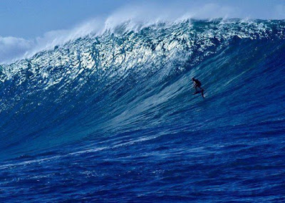
A shortboard and a longboard session for me yesterday. This is a remarkable shot (by Tim Bonithon) of Kai Lenny in his recent foil session at Jaws. The caption was: Next step is to go way faster and much bigger!
Pretty much the opposite of what I like to do with the foil: go slower on smaller waves.
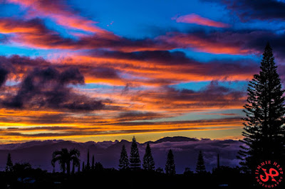
Yesterday's clouds pay back was served at sunset. Photo by Jimmie Hepp.
5am significant buoy readings
South shore
No indication of southerly energy at the buoys, the Surfline forecast calls for 1.1f 10s.
North shore
NW101
Pauwela
7.2ft @ 10s from 90° (E)
I believe that WNW energy at the NW101 buoy is generated locally by the low pressure just north of it and will never get here. So we focus in the Pauwela buoy instead, which shows a healthy easterly windswell and a fun size N swell. The winds are going to be very favorable, so today it should be a great day of surfing. Size doesn't matter, what counts is how clean the waves are. In my opinion, at least. And that's why I'm here posting the Windguru 10 days table to show that finally those stubborn easterly trades are going to give way to some calm, muggy days.

Wind map at noon shows a southerly around the island, but with onshore breezes in the protected shores.

North Pacific shows three fetches: W, N and E.

Too bad there's nothing in the South Pacific, otherwise it could have been an around the compass day of wave generation.

Morning sky.

Pretty much the opposite of what I like to do with the foil: go slower on smaller waves.

Yesterday's clouds pay back was served at sunset. Photo by Jimmie Hepp.

5am significant buoy readings
South shore
No indication of southerly energy at the buoys, the Surfline forecast calls for 1.1f 10s.
North shore
NW101
5.1ft @ 11s from 287° (WNW)
Pauwela
7.2ft @ 10s from 90° (E)
3.3ft @ 13s from 2° (N)
I believe that WNW energy at the NW101 buoy is generated locally by the low pressure just north of it and will never get here. So we focus in the Pauwela buoy instead, which shows a healthy easterly windswell and a fun size N swell. The winds are going to be very favorable, so today it should be a great day of surfing. Size doesn't matter, what counts is how clean the waves are. In my opinion, at least. And that's why I'm here posting the Windguru 10 days table to show that finally those stubborn easterly trades are going to give way to some calm, muggy days.

Wind map at noon shows a southerly around the island, but with onshore breezes in the protected shores.

North Pacific shows three fetches: W, N and E.

Too bad there's nothing in the South Pacific, otherwise it could have been an around the compass day of wave generation.

Morning sky.

Subscribe to:
Comments (Atom)


