Maui north shore (indicative of what's in the water on Maui's north shore)
7.2ft @ 13s from 349° (NNW)
4.4ft @ 9s from 12° (NNE)
West lanai Maui north shore (indicative of what's in the water on Maui's south shore)
Below is today's weather map. Without getting into details of why the air moves the way it moves, just suck in the information that it moves clockwise around areas of high pressure and counter clockwise around areas of low pressure (the opposite in the southern hemisphere).
Those black circles around highs and lows are called isobars and the straighter and the closer to each other, the stronger the wind will be in that area.
In addition to that, the longer and wider that area (called fetch) is, the bigger the waves it will generate.
But all those words are obsolete, because now there's a graphic tool that explains it much better!
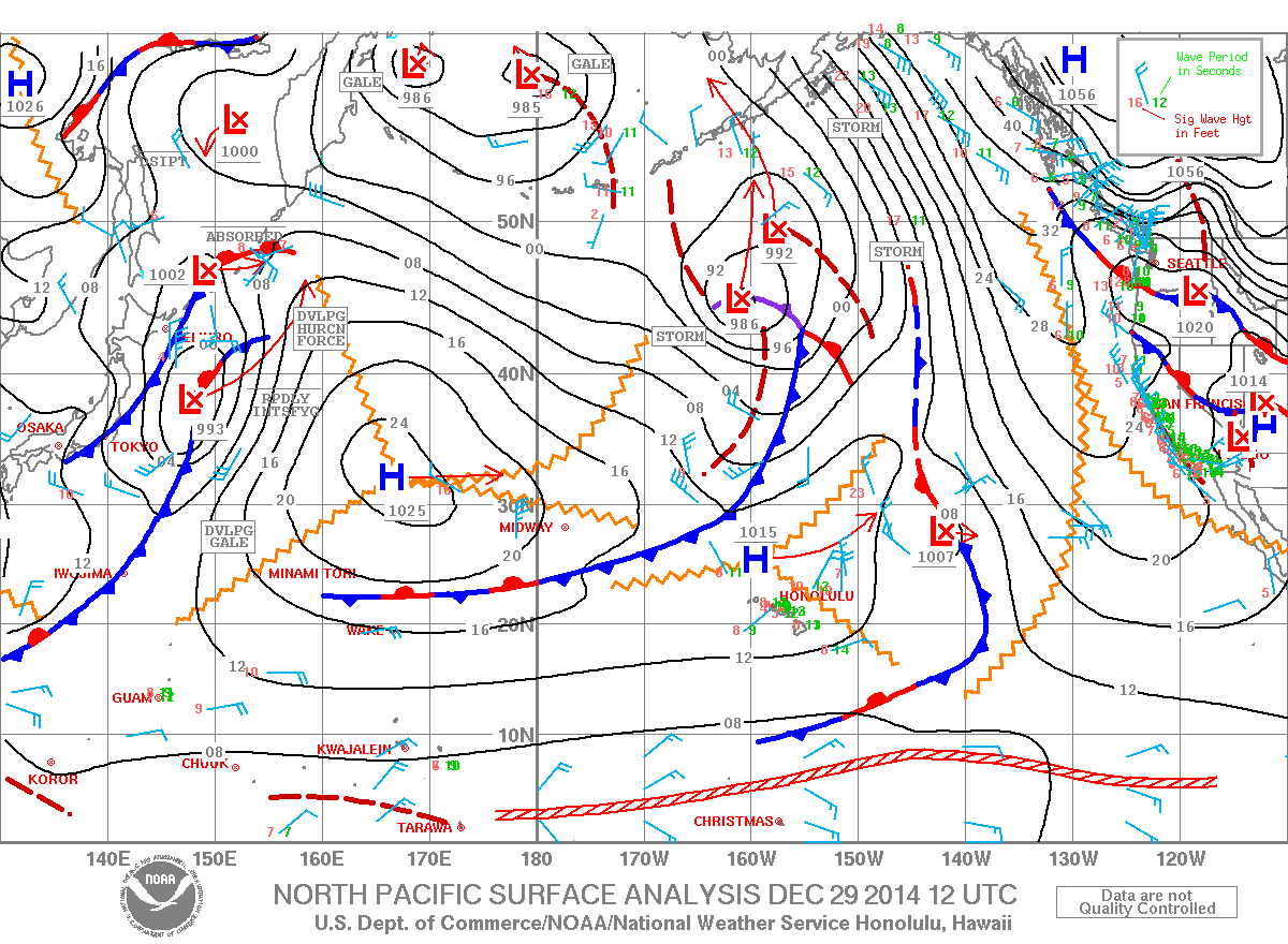
I'm talking about links n.2 and n.4 on the right, from which I below show a snip with arrows that illustrate the movement of the air. Please spend a moment to compare the two. They are exactly the same thing, just graphically represented in a different way.

Hope that helped someone (Jimmie, I was thinking of you...). Now let's talk about what's on tap for today.
Two swells at the maui buoy:
a) 7.2ft @ 13s from 349° (NNW). Uh, that's a beautiful direction for the whole west side of Maui!
West lanai Maui north shore (indicative of what's in the water on Maui's south shore)
2.5ft @ 13s from 297° (WNW)
1.8ft @ 9s from 304° (WNW)
I'd like to thank the reader that posted this comment on the last post:
"thank you for posting this. Im starting to actually understand this stuff."
Believe it or not, that's the main reason why I do this. The lack of knowledge (and abundance of laziness) of MOST surfers/windsurfers when it comes to understanding how waves and weather work is something that somehow annoys me. That's why I'm try to divulge a bit of knowledge. Not because I'm generous, but so that I won't be annoyed as much! :)
Anyway, that comment made me think that maybe I should try to explain real quick how to read a weather map. The easiest task of all, IMO, but such a still ununderstood one by many.
Below is today's weather map. Without getting into details of why the air moves the way it moves, just suck in the information that it moves clockwise around areas of high pressure and counter clockwise around areas of low pressure (the opposite in the southern hemisphere).
Those black circles around highs and lows are called isobars and the straighter and the closer to each other, the stronger the wind will be in that area.
In addition to that, the longer and wider that area (called fetch) is, the bigger the waves it will generate.
But all those words are obsolete, because now there's a graphic tool that explains it much better!
I'm talking about links n.2 and n.4 on the right, from which I below show a snip with arrows that illustrate the movement of the air. Please spend a moment to compare the two. They are exactly the same thing, just graphically represented in a different way.
Hope that helped someone (Jimmie, I was thinking of you...). Now let's talk about what's on tap for today.
Two swells at the maui buoy:
a) 7.2ft @ 13s from 349° (NNW). Uh, that's a beautiful direction for the whole west side of Maui!
b) 4.4ft @ 9s from 12° (NNE). Nice direction for a bunch of other spots, but definitely smaller in size and most importantly in period.
One day I'll try to explain with my words what the period is/does, but in the meantime this is a good article on surfline. Have a read.
The great news is that finally the MC @ 2km website is working again (link n.17) and we have now a clear picture of how the wind will be in Maui all day, hour by hour. It can be wrong too, in the end the wind does whatever it wants to do, but I find it the most accurate and reliable. Like 95% reliable.
Well, it says that today, unlike yesterday when some knowledgeable sailors/kiters got some sailing down on the west side, it should be a pretty much windless day all day, so wax up your boards!
Photo from Hookipa coming up soon, even though I hope most of you know by now that 7f, 13s, from an unblocked direction like 349 means WELL overhead waves.
Have fun in the sun everyone!


10 comments:
Thanks, you have one more reader now that starts to understand this. Just not sure just yet what makes the wind blow here but maybe I should browse some older posts as well since I just started reading this.
Well today you did a great educational job!! I read all of what you sent and the Surfline article was over the top!! I learned a lot from that. I'll never look at a Windguru chart the same again!!
I still want to sit and drink a beer and pick your brain in person!!
I love your insight as I too have learned from your posts. Primarily where to source better wind forecasting. The winter swell buoy readings are pretty easy for me now.
I just hope you can mix in some cooking recipes to round out the blog, and maybe some fashion tips.
Hehe, I just trying make funny.
not sure I'm the right guy about the fashion tips, but I'm waiting for a recipe from my dad and he's the right guy for that! Stay tuned, you never know...
just saw only now the comment from Unknown.
Well, your chances are way higher if you're a hot female.
sorry, I'm replying to the comments backwards. Johan, where's here? Anyway, in the end the answer is always the
difference in barometric pressure between two areas.
Here is Maui North shore right now. So there is basically no local phenomenon that enforces the wind.
in Maui the ENE trade winds are amplified by both:
- thermal effect due to the heating of the land
- venture effect due to the cliffs of the mountain
Check the maui county @ 2km map every day (whenever they update it) and in a week or two you won't have any more questions on how the wind works... here.
Thanks! Btw, looks like the "wave generator" went away now :(
And your link #4 does not seem to work.
thanks, I fixed it.
Post a Comment