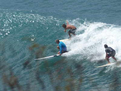
Here's some photos from the bay. Classic Honolua party wave.

There were some really fun waves at the point.


Meanwhile, at Hookipa the windsurfers were hitting the big and unruly waves.

Photos by Jimmie Hepp from this gallery.

4am significant buoy readings
South shore
SW
3.1ft @ 14s from 134° (SE)
That's the only indication of continuing southerly energy at the outer buoys, but that is good enough.
Below is the collage of the maps (starting from the left) of September 28, 29 and 30 that show the fetches of which we're getting the angular spreading.
Yesterday was a solid waist high again, looks like today it might be bigger. Stay tuned for a report later.

North shore
NW101
11.5ft @ 9s from 56° (ENE)
N
N
8.9ft @ 9s from 10° (N)
Waimea
Waimea
5.8ft @ 9s from 7° (N)
5.1ft @ 12s from 339° (NNW)
Pauwela
Pauwela
7.8ft @ 8s from 65° (ENE)
4.2ft @ 13s from 341° (NNW)
Still plenty energy on the north shore, but the trades are still pretty strong and it's going to be quite rough.
North Pacific shows a moderate and very close NE fetch created by a strong high and a newly formed low. That is going to hit during the weekend that will see progressively lighter winds.
Still plenty energy on the north shore, but the trades are still pretty strong and it's going to be quite rough.
North Pacific shows a moderate and very close NE fetch created by a strong high and a newly formed low. That is going to hit during the weekend that will see progressively lighter winds.

South Pacific shows some winds oriented towards us way down south.

Morning sky shows a line of clouds associated with the low creating the NE fetch.

Those clouds are moving south towards us and you can see them and the mother low better in this big picture.


No comments:
Post a Comment