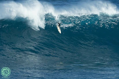
Yesterday ranked pretty high in gorgeousness. Photo by Jimmie Hepp.

Yesterday was also the day after the Jaws contest and many more shots were posted on the social media. This is women's winner Paige Alms on a bomb. Check the incredible rescue happening on the inside. What a vision they must have had.

And this is that incredible 10 by men's winner Ian Walsh. Photo by Erik Aeder.

This photo by John Patao shows 13 years old Ty Simpson-Kane on his Jaws free surfing debut. Easy to predict he'll be in the contest soon.

4am significant buoy readings
South shore
N
1.6ft @ 14s from 196° (SSW)
Once again, the only southerly energy is recorded by the northerly buoys. Thousand Peaks had very inconsistent (sets were 10-20 minutes apart, sometimes even more) knee to waist high waves, with some occasional belly high bombs. Surfline calls for 1.3f 14s, so it should be similar today.
North shore
NW001
3.4ft @ 9s from 329° (NW)
Waimea
2.4ft @ 9s from 355° (N)
1.6ft @ 11s from 313° (NW)
The energy from the Jaws swell has disappeared, we're left with the shorter period declining energy from that northerly fetch closer to us. If you don't remember it, scroll down to the past days calls. Here's how Pat Caldwell describes it.
A weak, stationary low pressure system to the NNE of Hawaii 10/26-30 had strongest winds 10/26-27 with the tail of the fetch about 1600 nm. By 10/28, winds were moderate to fresh. This event peaked locally 10/28-29 and is dropping 10/30. It should fade out on Tuesday.
And here's how he describes the fetch of the next swell that in Maui will probably hit only tomorrow.
A new low formed east of Kamchatka 10/26 with lower-end gales that moved eastward over the 310-320 degree band into 10/28. As the associated front approached the Date Line late 10/28, the system occluded. This ended the energy from the WNW as winds to the west side of the low just east of the Date Line had highest seas aimed more north to south at targets SW of Hawaii.
Surf should build from 310-320 degrees Tuesday afternoon and hold at levels below average on Wednesday. It should drop from this direction Thursday.
So overall a pretty small day for the north shore's fall average, but with very clean conditions due to the lack of wind. Stay tuned for an early morning beach update from Hookipa.
My usual wind model didn't get updated, so we look at the two models at the bottom of the windguru page that show very little wind for today.

North Pacific shows a WNW fetch. Unfortunately part of it is behind the Kurils, but there's some wind also in front of them.

South Pacific shows a moderate fetch.

Morning sky shows some clouds moving in from the SE.


No comments:
Post a Comment