Saturday, April 11, 2015

No time to drive to the lookout, waves are head high with a bit of wind.

11 4 15 morning call

Three lovely sessions yesterday (early and late surfing and mid day windsurfing).

Thanks to the NW swell generated by the fetch I circled on the map on Wednesday and Thursday's call, the waves were head high. Unlike this one below showing the author trying to do a little lame aerial off the back. Aerials scare the hell out of me, and I try to learn them in a safe way. I do not want to get injured now, that's for sure.


Buoys at 6am
NW
6ft @ 8s from 55° (ENE)
2.9ft @ 11s from 347° (NNW)
1.8ft @ 5s from 59° (ENE)

Pauwela
5.8ft @ 8s from 40° (NE)
2.9ft @ 11s from 340° (NNW)

Lanai
1.8ft @ 8s from 176° (S)
1.3ft @ 14s from 189° (S)
1.1ft @ 11s from 192° (SSW)

Still 3 feet at the NW buoy means that the NW swell will continue at least all day today. Direction is very favorable for Maui's north shore with no energy dispersed in refraction.

Minimal energy at the Lanai buoy, but still something for the Hi-Tech organized interscholastic championship at the Lahaina harbor. Just checked the webcam and it's obviously packed before the start of the contest.

 
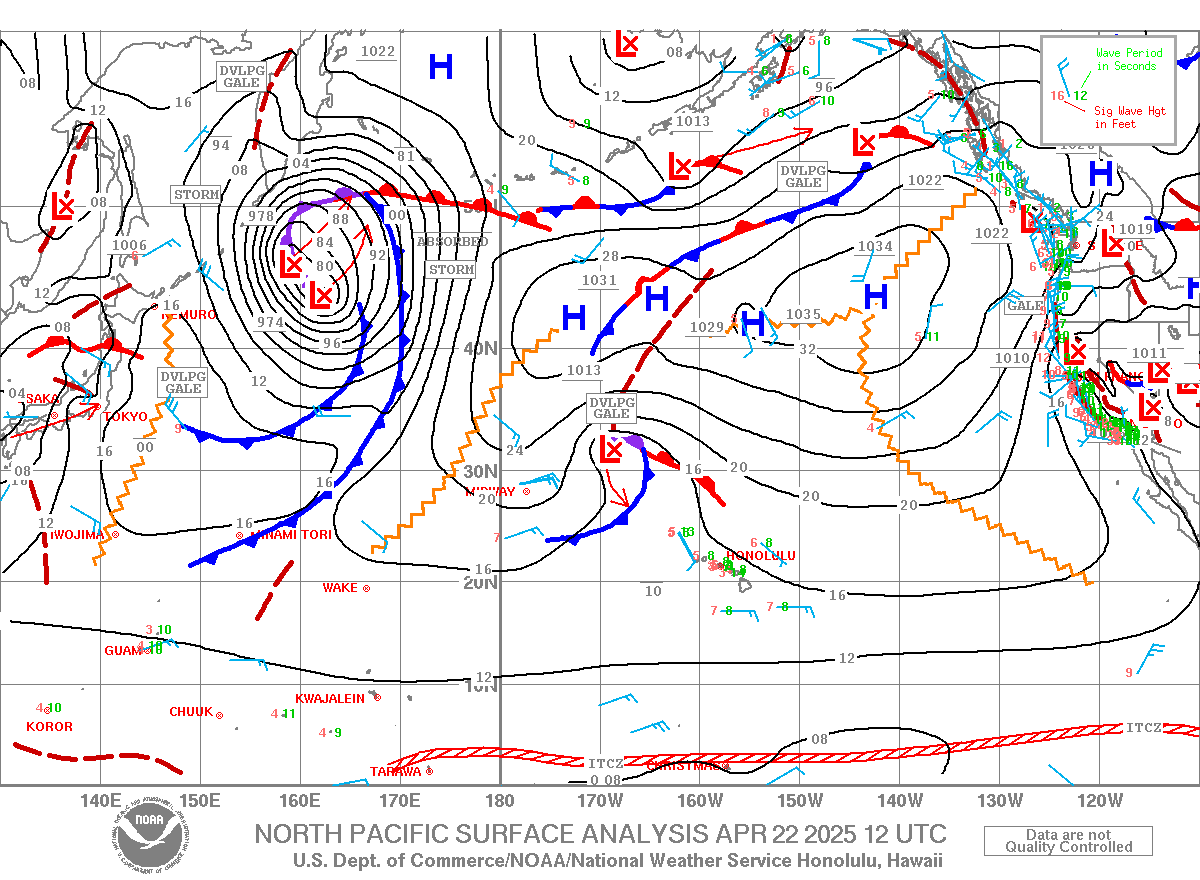
 Wind map doesn't show any fetches oriented towards us again, so the first days of the week will be pretty small until the big swell still in the forecasted map will hit on Wednesday. Small, but not flat, thanks to the angular spreading of the swell generated by that fetch up north (south of the Aleutians) that is mostly directed to Canada and west coast.
 

MC2km map at noon shows wind, but a little less than the past few days. Too bad that my physical therapist told me to stop windsurfing until my trigger finger problem is solved. I'll have to stick to surfing... or disobey her! I put a banner of her business up, hit her up if you need, she's awesome.


Friday, April 10, 2015

Chest high nw sets occasionally hitting pavils and the point, but poor conditions due to wind and windswell

4 10 15 morning call

Just a quick early session for me yesterday, then full day of work. The reason why I'm taking so many extra jobs than usual is coming up soon.
This is a photo from that session, it's almost like I have a personal photographer these days.


Maurizio took some photos of the windsurfers later on too and this is Hot Sails Maui team rider Kauli Seadi with his new Italian boards 99 (nove nove). Old friend Browsinho watches attentively.

Buoys at 6am.
Pauwela sees still a bit of energy from the NNW and a not so big windswell.
3.4ft @ 6s from 73° (ENE)           
2.9ft @ 8s from 76° (ENE)
 
2.6ft @ 12s from 335° (NNW)

Lanai 1.4ft @ 14s from 197° (SSW). South shore not flat, but watch the cam before going.
Wind map totally depressing with no fetches directed towards Hawaii in the whole pacific ocean. Weekend is gonna be pretty small/flat.
 

Today it's gonna be windy again, as the MC2km map at noon shows, enjoy your day.


Thursday, April 09, 2015

I saw a chest high nw set from the highway, but now it's only wind and windswell.

9 4 15 morning call

Pretty average day yesterday on both shores. Perfect for my surfing students instead.

This is a photo from 2006, that's the very first digital gopro camera that was launched and that's the first nose of the board mount I came up with (no sticky plates yet). It worked, but the board was super slow because the strap was catching water on the bottom. I learned something there.


Buoys are showing a bit of energy from the NW, but I would not be too excited about 1.4ft @ 14s from 332° (NNW). Minimal energy at the Lanai buoy too and that's what the Lahaina webcam shows too. Report from Hookipa coming up soon.
NW
5.8ft @ 8s from 95° (E)           
3ft @ 12s from 7° (N)

Waimea
4ft @ 6s from 39° (NE)
1.9ft @ 11s from 9° (N)
1.3ft @ 14s from 339° (NNW)
 
Pauwela
4ft @ 7s from 78° (ENE)
4ft @ 8s from 77° (ENE)
1.5ft @ 5s from 66° (ENE)
1.4ft @ 14s from 332° (NNW)

Lanai
1.5ft @ 7s from 167° (SSE)
1.3ft @ 3s from 26° (NNE)
1.1ft @ 16s from 196° (SSW)
1ft @ 13s from 188° (S)
 
Wind map shows nice not too strong wind, but notice the little component of onshore direction, specially in the original direction off Hana.

That is confirmed also by the large scale wind map, that also shows a minimal fetch up north shooting mostly towards central America.
North shore is gonna be pretty small until next week Thursday/Friday. Hopefully already Wednesday.
The storm doesn't look as impressive as it did a couple of days ago, but we should get a swell still much better than what we have now.


 And a couple of small fetches down south too, just to keep the background level surf up.

Wednesday, April 08, 2015

8 4 15 morning call

Couple of surf sessions early and late yesterday, that's all I need. The photo is from the sunset one.


Now I'm gonna brag a bit (I love doing that, don't I?).
A week ago I started pointing out a fetch all the way down south. Here's one of those maps to refresh your memory.


Then later on I noticed an interesting reading at the Samoa buoy and that seemed like a confirmation that some energy was coming our way.
And today, as we can see from the lanai buoy, here it is: 0.9f 18s.

 The thing that makes me most proud is that there's no mention of it in Pat Caldwell's table below.
Which does not mean that I'm claiming to be even remotely comparable to him. But I did good on this one.


So, south will have something. North will have something too, but way smaller period and way more wind: 4.4ft @ 8s from 77° (ENE)
That's why I'll leave in the dark. That's why I do all this. Analyzing everything in life to keep my brain active (doesn't like to rest) and take advantage of the things I find out.

Wind map today shows a nice lil fetch up there and we thank mother nature for that. Nothing to be too excited about, but just enough to keep the flatness away from the north shores.
 

MC2km not updated yet, the two models at the bottom of the windguru page show that yes, it's gonna blow pretty strong today. NAM always shows stronger than HRW. You pick your favorite.

Tuesday, April 07, 2015

I only see windswell and the point is bigger than pavils. Interesting.

7 4 15 morning call

Just a quick early morning sesh at Pavils for me yesterday and then a full day of work.
I don't mind working when the office looks like this... weather was absolutely gorgeous yesterday (photo by Jimmie Hepp).

BTW, HST is looking for instructors. Here's their fb post:
Want to call Kanaha your office? HST is accepting applications for instructor positions - windsurfing and/or kitesurfing. Please email your resume to info@hstwindsurfing.com or call us at 808)871-5423.


I don't mind working also when it means taking care of the details for a photoshoot like this! This old photo popped out on facebook again and I'd like to thank Frankie again for calling me for help that day!


Buoys (only the significant swells):
NW: 4ft @ 11s from 338° (NNW)
Waimea: 2ft @ 13s from 317° (NW)
Pauwela: 4.9ft @ 9s from 67° (ENE)
1.8ft @ 14s from 320° (NW)
Lanai: 1.4ft @ 14s from 235° (WSW)
0.9ft @ 11s from 210° (SSW)

Do I have to comment on the buoys all the times? Did you guys learn how to read them yet?
Here we go: 5f 9s windswell will make chest to head high waves at pavils and the point.
When a set of the 2f14s NW ground swell will squeeze in, there will be a more clear line (probably still head high) that will have a bunch of windswell subpeaks in it. The wind will be on it and it's gonna be average conditions, but good workout no matter what.
You learn how to read the buoys, you need no webcam, no beach report, no mauisurfreport blog anymore.

Wind map today looks pretty bad with some scattered insignificant fetches here and there.


A much much more exciting situation will pan out around NEXT Tuesday. Check the weather map below. I can read the number 960 in the middle of that winter caliber storm and that's a hell of a low.
Surfline calls for 11f 15s on Friday 17, but those are always over estimated. For sure, there will be a last winter whiplash. All the springtime vacationers will be stoked, because they will have the chance to see the big Hawaiian waves, Jaws included.
Hey, that's a forecast, things can change.


Today's wind map at noon shows the usual strong trades.

Monday, April 06, 2015