This is a photo of Hookipa yesterday morning. classic bumps, ribs and overall poor shape. Hard to test a board there if the opportunities of doing something good are so limited.

4am significant buoy readings and discussion.
South shore
Lanai
1ft @ 13s from 206° (SSW)
0.3ft @ 20s from 195° (SSW)
1ft 13s might make for some small waves (although the fact that is not recorded by Barbers is not encouraging), but what's even better is the 0.3ft 20s reading. Below are the maps of Nov 23 and 24, that show the fetch that generated a swell that should bring a little long period off season south swell, which should be better filled in tomorrow. Btw, Sunday/Monday the Lahaina area could have waves both from the south and from the N wrap.

Check the Lahaina webcam for today's size and conditions. Unfortunately it's heavily stuttering today, but I was able to capture this small clean line.

North shore
NW001
Waimea
4.2ft @ 8s from 13° (NNE)
3.5ft @ 7s from 33° (NE)
1.8ft @ 13s from 354° (N)
Pauwela
Pauwela
4.8ft @ 6s from 78° (ENE)
4.8ft @ 9s from 52° (ENE)
2.3ft @ 13s from 5° (N)
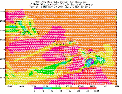
The last two swells on the Pauwela list are going to be the ones that will characterize the waves on the north shore today (Hookipa should be at least head high). Actually, what it will unfortunately characterize them even more is the strong wind. Expect blown out conditions all day, unless you're lucky/patient enough to catch an after squall temporary break.
Btw, the big N swell is only tomorrow for Maui.
Wind map at noon.
Btw, the big N swell is only tomorrow for Maui.
Wind map at noon.

Kahului Tides
High Tide High Tide Low Tide Low Tide Sunrise Sunset
5:21a +2.5 3:17p +1.1 12:39p +1.0 10:01p +0.1 6:47a 5:45p
North Pacific has the circled fetches in the picture. The fetch of the N swell is now entirely aiming east of us, we only have that NE one close by, which will only add short period disturbances to the long period energy that is on its way (should be, at least). Based on this observation, I'm going to predict again that this long period N swell is not going to be particularly long lasting, despite the fact that yesterday afternoon I read Pat Caldwell saying the opposite. Unfortunately, this morning that page (link n.9) is not available (Geoff, I might need your investigation here), let's hope it comes back up soon.
Oh, if you were wondering why the NW buoy is reading 10ft 10s from ENE, I put a little red X to indicate its position... which explains the reading, as it's right in the middle of the active seas. We are going to be exposed to NE energy too and that is the one that is going to be long lasting.
To recap:
- long period N energy will last mostly Sunday/Monday and then decline noticeably on Tuesday
- shorter period NE energy should stick around all next week instead.

Nothing from the south.

Morning sky.


No comments:
Post a Comment