3-4am significant buoy readings
South shore
W
1.9ft @ 14s from 157° (SSE)
SW
2.3ft @ 15s from 162° (SSE)
SE
2.3ft @ 15s from 177° (S)
Barbers
1.5ft @ 17s from 185° (S)
Lanai (NOAA)
| 1.6f | 16.7s | (S) |
Decent numbers at the buoys, as predicted a new low long period swell is filling in from the South. I'm very perplexed about the 3s difference in the period between W and Barbers and I have no explanation for it. I can understand how the detection of the direction can be challenging in rough seas, but the period shouldn't be affected. Anyway, Lanai records 16.7s too, so we have long period energy locally in the water and that's good news. Stay tuned for a beach report around 7am.
North shore
Pauwela
5.8ft @ 8s from 60° (ENE)
Get used to windswell only on the north shore, I don't see any change for at least two weeks. Size should be similar to yesterday, waist to chest high with occasional bigger sets.
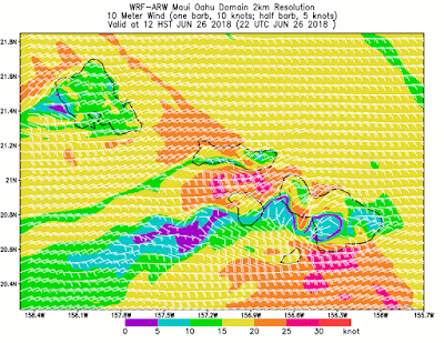
Wind map at noon.

North Pacific has a remote WNW fetch and the local windswell one. As you can see from the color on the map on the right, the intensity of the wind is pretty similar, but only the second one will produce waves for us, thanks to its proximity. The ones made by the first one are going to be to weak (small and low period) to make it all the way over here.

South Pacific would have a decent fetch, but it's sitting right on top of New Zealand and that breaks it down into two so and so fetches.

Morning sky


No comments:
Post a Comment