This photo is from Jason Hall from a spot in town.

And this is another town spot photographed by Rise Lively.

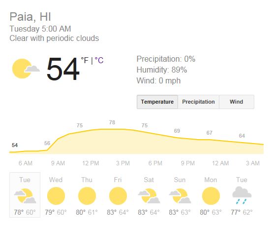
The skies stayed clear during the night and so most of the heat that the Earth accumulated during the day was free to migrate back into the space. As a consequence, this is the temperature in Paia this morning. That is 12 Celsius (after 15 years I still struggle with the Fahrenheit) and that's as cold as I ever remember it. My little electric heater is on while I write this.
Notice how steep the increment prediction is. By 10am, it should be back to the usual 75F (24C). Gotta love Hawaii!
Plenty waves on tap also today (but no sign of the XXL swell just yet) as the graphs of the three buoys seems pretty steady. Actually Pauwela has the biggest and "cleanest" reading at 5am: 12.4ft @ 13s from 334° (NNW).
Seen the abundance of secondary swells at the other buoys though, I would still expect the waves to be influenced a bit by the northerly windswell that has populated (or should I say infested) our north shore waters the last couple of days. But the windswell dies down quickly, so hopefully that reading is true and thanks to the early morning's light offshores it's gonna be epic!
BTW, the Eddie will be on tomorrow and you can watch the webcast here.

Wind map shows the intense NW fetch that has already generated the XXL Wednesday's swell (on its way) still in place. Good, we'll have waves till the end of the week. After that, a new WNW swell will hit (Sunday) and that new fetch off Japan is the one that will stir it.
The blue circle indicate the magic narrow strip of ocean with no wind. We are in the middle of it today, but unfortunately things are about to change soon and the trades will start blowing again.

MC2km map at noon shows the lack of wind. Early morning should see offshore land breezes, the afternoon should see onshore sea breezes. When it's like this, this otherwise remarkable model sometimes is not the most accurate. That's totally understandable, since the intensity of the breezes will depend on the amount of clouds covering the mountains and there's no way any model can predict that precisely.
Fortunately when it's like this, it's also when you need a wind prediction the least. You know that at one point an onshore breeze is going to pick up. If that bothers you, surf early. If it doesn't, or you even prefer it since some people will leave the lineup, surf late.


No comments:
Post a Comment