Two morning sessions for me, this is young Caden at Thousand Peaks mid morning still very clean.
Buoys
Pauwela
2.9ft @ 9s from 9° (N)
1.1ft @ 5s from 33° (NE)
0.8ft @ 13s from 3° (N)
Barbers
2.3ft @ 14s from 194° (SSW)
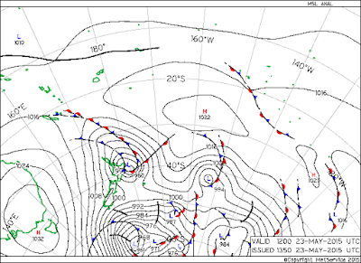
New swell on the rise. But very little energy from it today, since the fetch was still over New Zealand as the map of the 23 shows.

If you want to know what happened next, read the wonderful discussion of Uncle Pat Caldwell on his website. Here's a brief quote.
As swell trains travel, the dominant period lengthens, and with the long travel distance, this should allow significant energy within 20-25 seconds in Hawaii on Sunday. Extreme wave periods have long wave lengths, which in turn allow them to feel the ocean bottom in much deeper water. This allows wave energy to bend and can focus this energy in select locations. As the swell transforms to a breaker, the extra-long period swell amplify much more than usual.
Most remote source events take up to a day to fill in, as we have seen for common events this season. But not when the source is extreme as in this case when the longer period portion of the spectrum becomes elevated. This should mean a faster ramp-up period at the start of the event early Sunday with well above average breakers on the common, though less frequent sets on Sunday morning. It should continue an upward trend through the day Sunday from 180-195 degrees
I'm getting the stepup in the car.
Wind today will start light everywhere, but later in the day there will be a brief NE trades episode. This is the MC2km map at 3. Might even be sailable for the desperate wind sport passionates.
No fetches of relevance in the north pacific for the second day in a rom, expect some flatness on the north shore in the next few days. Not today yet, seen the Pauwela readings.
Barbers still up, if you have time, go south.
The fetch down under is now pointing more to south America, we'll still get some angular spreading, but that will mean the end of this week's swell around next Saturday... one more full week of waves, could be worse!
Notice also a hurricane off Mexico. It will track NE and will send a mid period easterly swell towards Friday/Saturday (like 3f 12s).


No comments:
Post a Comment