Tuesday, December 22, 2015

12 22 15 morning call

Yesterday was a relatively sunny day, considering how strong the trades were. Two reasons for that:

1) the wind was from an easterly direction. The more east (hence slightly sideoff on the north shore) the less squalls will make it around the corner and hit Hookipa and the rest of the north shore. The more north, the more wet the weather on the north shore, also because the air will be colder.
2) the air around the islands was relatively stable and dry.

I'll come back to both points later in this post, in the meantime, let me open with a photo by Jimmie Hepp that shows both a nice light and a relatively clean wave at Hookipa. Sailor looks like Max Schettewi.


The easterly direction might help the sunshine and the cleanness of the waves, but definitely not the steadiness of the wind. Below is yesterday's iWindsurf.com graph for Hookipa. Every time the gap between lulls and gusts is 20mph or more, it means it was gusty as hell and the whole afternoon was like that.


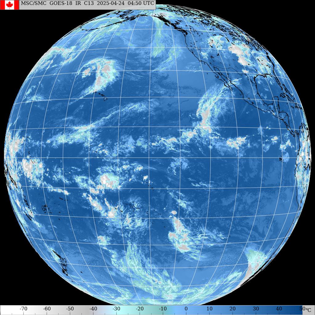
What did I mean with stable and dry air around us? The answer is in the wonderful image below. We are were the arrow on the left is. A much more humid zone is where the right arrow is. Is it gonna move on top of us? Sorry, I have no interest/skill in forecasting that. Keep checking the maps every day and you'll have an idea of how the cloud cover is going to be that day. Links 5 through 8 are helpful for that.


Buoys 4am
NW
9.1ft @ 10s from 97° (E)           
4ft @ 13s from 292° (WNW)
3.3ft @ 4s from 112° (ESE)

N
11ft @ 10s from 97° (E)
3.4ft @ 5s from 79° (ENE)
2.8ft @ 15s from 348° (NNW)

Waimea
5.4ft @ 9s from 40° (NE)
3.1ft @ 15s from 324° (NW)
2.1ft @ 4s from 38° (NE)

Pauwela
8.6ft @ 10s from 62° (ENE)
5.2ft @ 6s from 69° (ENE)
2.2ft @ 15s from 340° (NNW)

Considering that the N buoy allegedly is adrift west of NW buoy (that's what Pat Caldwell wrote some weeks ago) and that all the graphs are influenced by the strong windswell, I'm not even gonna try to justify the apparently weird directions of the new NW swell.
In addition to the windswell, in Maui there's 2.2f 15s from 340 which will possibly grow a bit more. In the end, that's all you need to know. That's why I called the buoy link (n.5) "the bible". When you're lost and need something to blindly believe without questioning it, that's where you go.

Just like yesterday those 5f from the N were all you needed to know. As a matter of fact, I met a blog reader at the shop in the afternoon and he told me that he took two groms to a spot that worked nicely with the N swell that I pointed out and thanked me:"without your blog, I would have never known where to go".
Two groms scored because of the blog and that's some motivation for me to keep going.

Wind map offers a bunch of fetches north and south, so I split it. This is the northerly section.


This is the southerly one. The only fetch I feel like commenting is the SE one, since it doesn't happen often and when it does, we get heavily blocked by the Big Island.
As far as waves for Maui, the one SE of New Zealand is much better.


I'll leave you with a quote from Pat Caldwell:
In the northern hemisphere, a regime change is predicted for the jet stream, which is placed further south with a near zonal track from Japan to the longitudes of Hawaii 12/27-30. This would bring the surface low pressure cells closer and increase surf size locally to above average levels. Hints of the start of a WNW to NNW event 12/30.

Wait, I just found another shot from Jimmie that shows an extremely clear Haleakala top. Rare sight in winter? Not really. Rare sight in a windy day in winter? Sure is!


MC2km map at noon shows the wind that it shows.

Monday, December 21, 2015

12 21 15 morning call

Yesterday I decided to escape the windy and squally weather of the north shore and went to spend my day with a good book on a beach in Kihei. It was lovely. Amazing the difference of climate you can find on the other side of the mountain.

Of course I did that because I'm still injured, otherwise I would have found fun things to do on the north shore, but the fact that I couldn't find a Maui action shot means that the action wasn't easy to find by most people. What I did find is this amazing photo from photographer Marco Mora that shows an exceptionally big swell in Tarifa (Spain).


At 5am Pauwela reads:
9.1ft @ 9s from 60° (ENE)
4.8ft @ 13s from 359° (N)
3ft @ 4s from 77° (ENE)

The windswell is still going strong, but it's surprising to see 5f 13s of that north swell I called yesterday. That number is twice as big than what Surfline forecasted, and that shows that sometimes the wave models do make mistakes.
It's also twice as big as the Waimea reading and there's no sign of it at the Hanalei one, which confirms the angular spreading nature of it, with the bulk of the swell missing us to the east. Check the fetches I highlighted in yesterday's post, if you didn't see it.

Today's map shows:
- a good fetch in the nw corner. It has been there already for a few days and today we're supposed to receive the long period forerunners of the related swell, but there's no sign of it yet at the NW buoy. Probably tomorrow for that one.
- the windswell fetch. This is one of the most stubborn high pressures I can remember. It seems that it's gonna let go a bit only towards the end of the year.
- not one, but two fetches down south!


The wind should be cranking again and the rain is hitting hard on my window as I type at 6am. Might end up in Kihei again...
Check later for the MC2km map.

Sunday, December 20, 2015

12 20 15 morning call

The photos below show the size of the windswell waves at Hookipa yesterday. The sailor is Andres Martinez, photos by Jimmie Hepp.


At 4am Pauwela has the following readings and I'm gonna comment on all of them. Keep in mind that the more a swell travels, the more the period increases and at the same time the size decreases (it loses half of the size every 1,000 nautical miles):
12.5ft @ 10s from 75° (ENE)
4.5ft @ 5s from 62° (ENE)
1.6ft @ 18s from 18° (NNE)

12.5ft @ 10s from 75° is a pretty solid couple of numbers for a windswell (even bigger than yesterday) and that doesn't happen all that often. It takes a fetch that is long, strong, long lasting and pretty close. I've been outlining it for the past many days, so you guys should be familiar with it.

4.5ft @ 5s from 62° is the windswell related to the active wind. That only adds chop and chaos on the face of the 10s waves that are instead already more organized, so from the surfing point of view, it would be better to be out of the fetch. Best to be in front of it, but not touched by it.

1.6ft @ 18s from 18° come from a fetch that was north of us on Dec 16 and 17. It was directed to the west coast and we're getting the angular spreading. I put those two wind maps together below.


Today's wind map shows three fetches:
- a solid NW one
- the usual windswell one
- a south one
Approximate travel times for the related swells are 4, 1 and 7 days.


The wind will be nuking again and, as you can see from the windguru table below, we're not done with it yet. Another strong episode is forecasted for the next weekend.
I should be happy that I'm not missing anything epic, but I still would prefer windless days... plus some spots actually might be epic.
I came here for the wind 15 years ago, I don't like it anymore now. And I know lots of people that did the same. Things change.


MC2km map at noon shows the wind that it shows.

Saturday, December 19, 2015

12 19 15 morning call

Couldn't find a decent shot from yesterday, so just in the very remote case that someone has still not seen it, here's Kelly's wave.
They did a really good job, but I would probably get bored after a while.


At 3am Pauwela reads 11.1ft @ 8s from 66° (ENE) and once again, it's all about the windswell.
Surprised about this much wind in a strong El Nino year?
Here's a Pat Caldwell quote from some video clips I was lucky enough to put my hands on:
"the average number of giant days (Hawaiian scale 20+) in strong el nino winters is 4. 1985-86 had 13 giant days despite being a neutral el nino year (actually slightly negative).
Mother nature doesn't like to be put into the cookie cutter..."

Wind map below shows three fetches:
- one in the NW corner
- the windswell one
- an out of season compact but decently strong south one. 1 to 2 feet swell in a week.


MC2km map at noon shows the wind that it shows: a hell lot of it.

Friday, December 18, 2015

12 18 15 morning call

Congratulations to Adriano De Souza for killing it yesterday and winning both the WSL World title and the Pipe Masters. Very much like the year that Parko won.

The WSL/Masurel photo I grabbed from this gallery is from the day before though, and that is for two reasons:
1) I feel like thanking the retiring CJ Hobgood for all the wonderful surfing and the spontaneity in his interviews and overall behavior
2) the waves were 100 times better than yesterday


This WSL season saw an incredible improvement in the production of the webcasts that went totally mainstream and professional. Too many little details to list. But of course they still have room to improve.
My biggest suggestion (other than getting rid of the annoying Dave Stanfield and his uninteresting stats and commentary), is to make better... morning calls.

They did a pretty good job overall, but Pipe was a disaster. Can't finish the whole season with such an ideally dramatic and open to all scenarios battle for the title in shitty waves like that!
In the previous days they had much better conditions than that. Take Monday for example (the day of that swell that surprised me). Or Tuesday afternoon. From 2 to 4pm it was slow but much, much better than yesterday. With a couple of hours here and a couple of hours there, they could have finished Wednesday in glorious waves like the one above.

I have no idea of how much it costs to keep a contest (and the whole production crew) on hold for half a day. I'm sure it's a lot of money, but having a final day with very average waves like yesterday must be an economical damage too. The more epic the show is, the more people will watch it and the more fans will be following the next contest/season (which translates into advertising money).

The Peahi contest was a clear example of that. It was called the right day, the waves were huge and the show was unprecedented. I saw photos and videos of it on facebook for the whole week after it.
And that's how you grow your fan base.

That's my little rant, let's move on to a photo taken by Jimmie Hepp at Hookipa yesterday. Matt Meola doesn't like to compete and stays true to his free spirit surfing.


The Pauwela buoy at 3am reads:
6.8ft @ 10s from 63° (ENE)
4.5ft @ 8s from 53° (ENE)
4ft @ 5s from 71° (ENE)
0.5ft @ 20s from 60° (ENE)
and that means that it's all about the windswell. That is going to be the case also in the weekend, even though a small north swell is forecasted to pick up this afternoon (made by the fetch that on dec 16th I said is shooting mostly to the west coast... scroll down a couple of posts for it). I don't see it at the buoys anywhere, probably completely shadowed by the raging windswell.

------- 7am Pauwela update -----------
6.1ft @ 8s from 62° (ENE)
5.1ft @ 9s from 65° (ENE)
4.7ft @ 12s from 350° (N)
so the N swell is at the bouy, you guys might even be able to see some lines in the middle of the chop.
---------------------------------------------

Wind map shows a fetch in the NW corner. The related low is massive (944 in the center), but it's north of the Aleutians and is going to move even more north. The high north of us is just as massive (1035) and not going anywhere.


Strong wind, huge chop and poor conditions over the north shore.
Remember, never ever under any circumstances get excited about a strong wind forecast in Maui. Not even, and actually specially, if you're a windsurfer/kiter. The stronger the wind, the more squalls there will be and the more up and down the wind will go and because of that, in the end, it's never really as strong as they predict.

Said that, the MC2km map at noon below shows the wind that it shows.


Thursday, December 17, 2015

12 17 15 morning call

Great day in multiple sports/spots yesterday.

Let's start with the most important: this is Mason Ho at Pipe in a WSL/Masurel photo that I cockroached from this great gallery.


Here in Maui there was some epicness too. This is Jason Hall at Honolua in a video frame grab by Wade Saunders.


And this is Morgan Noireaux at Hookipa.


Hot Sails Maui going back to the historical Spiderlock design. Not sure if that's a prototype, but I'm sure that as soon as I heal, I will want to try it. It was the sail that Dave Osborne used, and he only used one size in any wind: 4.5.
I feel very close to Dave's approach, since I do the same. Actually, my one and only size is 4.3, so don't waste your time asking me what size I'm rigging if you see me at the beach.
The reasons are well explained in this article that Dave wrote back than. I only read it a couple of years ago, after independently getting to the same conclusions myself.
Using one size sail only is not for everybody. Having a light weight sail like the Hot Sails Maui KS3 or Firelight IS an advantage for everybody.


The Pipe contest was fantastic to watch. A heat with Fanning, Slater and Florence together doesn't happen every day and I can't wait to watch the rest of it very soon.

Below is the graph of the three buoys. Unfortunately you can see how quickly the swell is decreasing.
That's too bad and I kind of called it many days in advance... it's never the best to end a contest (and a whole season) in declining waves, but the drama factor will still be there 100%.

Maui is reading 7.5ft @ 10s from 82° (E) and 5.4ft @ 14s from 316° (NW) and that should make for not particularly clean conditions on the north shore. I would probably go again on the west side to avoid the windswell and even more the wind that will once again blow strong and ruin the waves.


MC2km map at noon shows the wind that it shows.

 
 Wind map shows a small but decently strong fetch up in the NW corner and the usual windswell cone. We might even get a bit of angular spreading from that other fetch N of us, but it will be marginal.


Wednesday, December 16, 2015

12 16 15 morning call

I took this photo yesterday morning at Hookipa. Windswell looked allright.


Pretty big numbers at the buoys. The show at Pipeline should be intense, below is a webcam snap at 7am.


At 3am Pauwela reads
6.7ft @ 18s from 332° (NNW)
6.5ft @ 10s from 84° (E)
5.6ft @ 7s from 75° (ENE)
Too bad today is going to be real windy, otherwise that would be Jaws stuff.
I'm sure some windsurfer/kiter will tackle it. Just make sure to bend your legs you guys when you're dropping on a 30 feet bomb and have to negotiate the chop. 6f 10s is a pretty serious windswell.
As far as surfing goes, due to the strong wind, the only possible call today is the west side.

Below the graph of NW, Waimea and Pauwela. NW peaked around sundown yesterday and stayed steady size wise (lost a couple of seconds in the period), so expect the swell to peak in the early morning both in Oahu and Maui and stay elevated throughout all day.


Wind map shows a decent fetch NNW of us mostly shooting at the west coast, and the usual windswell fetch.


MC2km map at noon shows the wind that it shows.

Tuesday, December 15, 2015

12 15 15 morning call

Really fun waves all day at Hookipa yesterday. The photo below shows the size.


I completely failed to spot the fetch generating them and I started shooting in the dark and panicing when I saw the buoy readings yesterday. Then I finally figured it out and posted a correction at the end of yesterday's call. Sorry about the confusion.

Today the Pipe contest could be resumed. The graph of the NW buoy doesn't look all that impressive to be honest. And since they showed many times that they don't like to hold it for a morning and just run the afternoon (plus in Hawaii they have to finish by 4), I'm gonna call it off.
(7.45 update: on hold till 11.45am.)

That would be a bummer because today the wind will be perfect and starting tomorrow it will start to get stronger. Also, if they don't run it today, they'll run tomorrow and Thursday and finish on a subsiding swell, which is never the best. But the drama is guaranteed.
Check the dawn patrol at 7.30 and you'll know.

This is the wave face Surfline forecast for Oahu's north shore for those three days. I never check this as I much prefer the offshore swell tab since the wave faces heights will be greatly different depending on the spot and the direction. Plus the offshore swell values are a lot easier to compare with the buoy readings to validate their accuracy.


Here's the graph of the NW and Waimea buoy at 5am. Light blue and green lines respectively.


Pauwela reads:
7.9ft @ 9s from 70° (ENE)
0.9ft @ 20s from 335° (NNW)
so the morning surf in Maui is going to be mostly provided by the windswell. Only in the afternoon there will be noticeable sets from the new swell.

I don't see any sign of that S swell I pointed out a week ago at the Barbers buoy:
2.2ft @ 9s from 268° (W)
1.3ft @ 11s from 227° (SW)
0.9ft @ 3s from 114° (ESE)
0.8ft @ 13s from 191° (SSW)

The wind map shows a weak fetch in the NW corner and a similar strength windswell one. Tons of windswell ahead.

MC2km noon map shows the wind that it shows.

Monday, December 14, 2015

12 14 15 morning call

Thanks to the sideoff wind the waves were again pretty clean all day at Hookipa yesterday.


The buoys at 4am present an interesting situation:
NW
6.9ft @ 10s from 7° (N)
2.5ft @ 7s from 20° (NNE)

Hanalei
8ft @ 11s from 337° (NNW)

Waimea
5ft @ 10s from 341° (NNW)

Pauwela
6.2ft @ 9s from 62° (ENE)

Yesterday evening the NW buoy was even up to 9f 10s from straight N. Well, don't get too excited, because those waves are never gonna make it to Maui, IMO.

Let's see why by looking at yesterday's wind map. I put a red arrow at the tip of which is where the NW buoy sits: 24N and 162W.
There was a small fetch oriented straight North to South (thick arrow). Nothing major but, due to the proximity, I believe that is where that energy came from.
And the readings at Hanalei and Waimea could be the angular spreading of it, which is not hitting Maui instead. That's my best attempt to justify those readings.
Maui has only windswell from 62 degrees and that is still much better than nothing.

Also because the wind should be again light ESE and that is just gold. Take advantage of it until it lasts, is my strong recommendation. I just did a 2 weeks windity run and I could see strong trades (with small to medium NW ground swells here and there) till the end.


Today's wind map shows that the little low I just elaborated about is pretty much gone. It also shows a weak fetch in the NW corner and the usual windswell cone.


MC2km map at noon shows the wind that it shows. Choose a spot that is exposed to the windswell is my recommendation.


Last but not least, I'd like to thank the blog sponsor SurfersList for renewing their banner.
SurfersList is a classified ads website for the watersports community that provides a platform to post surf, windsurf, kitesurf, and SUP equipment for sale. To learn more, view the short video "What is SurfersList?" (1:07min).

------------- 1pm update -----------------

A couple of hours ago, Pauwela was reading 6.5f 9s from 25. Hookipa was solid head high and clearly with a lot of north in it more than east.
I felt the urge to investigate further and finally I found the fetch that I was looking for this morning.
I apologize for the mistake.
Below is the weather map of Dec 11. I circled the fetch of the low that created this northerly energy.
The low moved quickly to the ENE and wasn't even on the map the day after. So, the swell is not gonna last long, but it looked really fun and uncrowded.


That day I posted the wind map below. I chose to capture the whole world because there were a couple of small fetches down south and I failed spotting that northerly fetch.
Might have to stick to close up maps in the future.

Sunday, December 13, 2015

12 13 15 morning call

Very clean waves at Hookipa yesterday. This was taken in the afternoon when the lineup wasn't as crowded as in the morning.


Pauwela at 4am reads:
6ft @ 9s from 82° (E)
2.7ft @ 12s from 342° (NNW)
2.3ft @ 6s from 81° (E)

Slightly smaller waves, but the wind is going to be ESE again, which will cause very clean conditions.

Barbers reads:
2.2ft @ 13s from 257° (WSW)
2ft @ 9s from 183° (S)
and this is the south pacific map of Dec 5th that shows the fetch south of New Zealand that made those waves. At least, that's my guess.


Wind map shows the fetch of Wednesday's swell start to go north of the Aleutians, but still with a nice area of strong wind generating waves towards us. The contest at Pipeline should be ok in terms of size.


Too bad it's going to be ruined by the wind which is going to blow very strong again. To be an El Nino year, this winter has been very windy so far.


MC2km map at noon shows the wind that it shows.