Hookipa yesterday morning.
Hookipa yesterday at sunset.
6am Surfline
significant buoy readings and discussion.
South shore
Barbers
Lanai
Mixed period small southerly energy at the buoys, check the Lahaina
webcam if interested, for size, conditions and consistency.

North shore
NW001
4.4ft @ 10s from 314° (NW)
Hanalei
3.8ft @ 10s from 318° (NW)
Waimea
Pauwela
As reported below this post, Hookipa was excellent again in the early morning, but already around 7am there was some texture from the trades that are predicted to come back, as indicated by this NOAA page:
A high pressure ridge will build and lift slowly northwest of the islands over the next few days, slowly increasing trade winds across the region.
It should stay around head high all day, with a slow downward trend as indicated by the PACIOOS forecast below (notice the next NW swell on July 2nd).
Forecast and energy spectrum of Pauwela from this PACIOOS page.

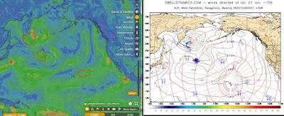
Wind map at noon. The other ones can be found here (click on animation of the 10 meter column).

Fetches map (circles legend: red: direct aim, blue: angular spreading, black: blocked) from Windy.
North Pacific (about 4 days travel time from the NW corner of the North Pacific):
South Pacific (about 7 days travel time from east/west of New Zealand):

Morning sky.


No comments:
Post a Comment