
Buoys' readings confirm that. Notice how nicely similar in shape the three graphs are (notice that the waimea one has a slightly different scale).
It's really no rocket science. I mean, it actually is if you want to understand and insert in a mathematical model all the variables that come into play if you want to predict the propagation of waves in the ocean, but there's no need as a surfer.
We let the Wave Watch III model do its job and here I just want to add consideration based on my local knowledge and a few easy rules like the travel times from the NW buoy and shadowing angles, which I have discussed in the last few posts.
5.9ft @ 17s from 326° (NW) at 5am at the Pauwela buoy is a good reading, but not a huge one. It will go up in size a bit more throughout the day (based on the NW buoy graph), but not by much. Maybe a foot or two.
Surfline's forecast for today was 8f 15s at 2pm, so we are in line with that. The forecast for Sunday at 8am is 15f 16s, so that is going to be a much bigger swell. Perfect day for running either the Eddie at Waimea or the Peahi Challenge at Jaws.
Nonetheless, I believe that both Honolua Bay and Sunset Beach will have enough size to resume the contests today.

In the NW corner of the wind map below, we see the strong fetch of the storm that will generate Sunday's swell. Straight north of us, there's the fetch of the storm that generated today's swell but, as you can see, it's now shooting towards southern California and Baja. I can see right handers peeling along the coastline already.
I also circled a couple of fetches that will not affect us, but will affect the Fiji islands. The SW one is a common and perfect direction for Cloudbreak, no idea of what that SE one will do. Tell you what, would love to be there and find out!

MC2km map at noon shows wind in the 15-20 knots range on the north shore.
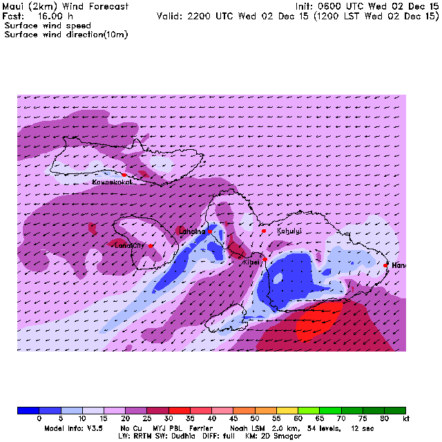
Different prediction by the NAM model on Windguru, which is always quite generous and which I post below. Way too generous in this occasion, imo.
Actually, if I look at the wind map above, I actually find even MC2km generous, but as I say that a nice gust of wind gets into my house and reminds me that I shouldn't try to guess the wind, because that depends on local factors (like squalls and cloud cover on the Haleakala) which are quite hard (if not impossible) to predict. So there you have it. Enjoy another great day in the water.


No comments:
Post a Comment